world.wikisort.org - France
Saint-Céré (French pronunciation: [sɛ̃ seʁe]; Languedocien: Sant Seren) is a commune in the Lot department, southern France.[2] Its population is 3,414 (2019). The commune includes within its borders the castle of Saint-Laurent-les-Tours, where the artist Jean Lurçat lived and worked for many years, and from which he operated a secret radio for the French Resistance.[3] The castle still houses a collection of his works.
Saint-Céré | |
|---|---|
Commune | |
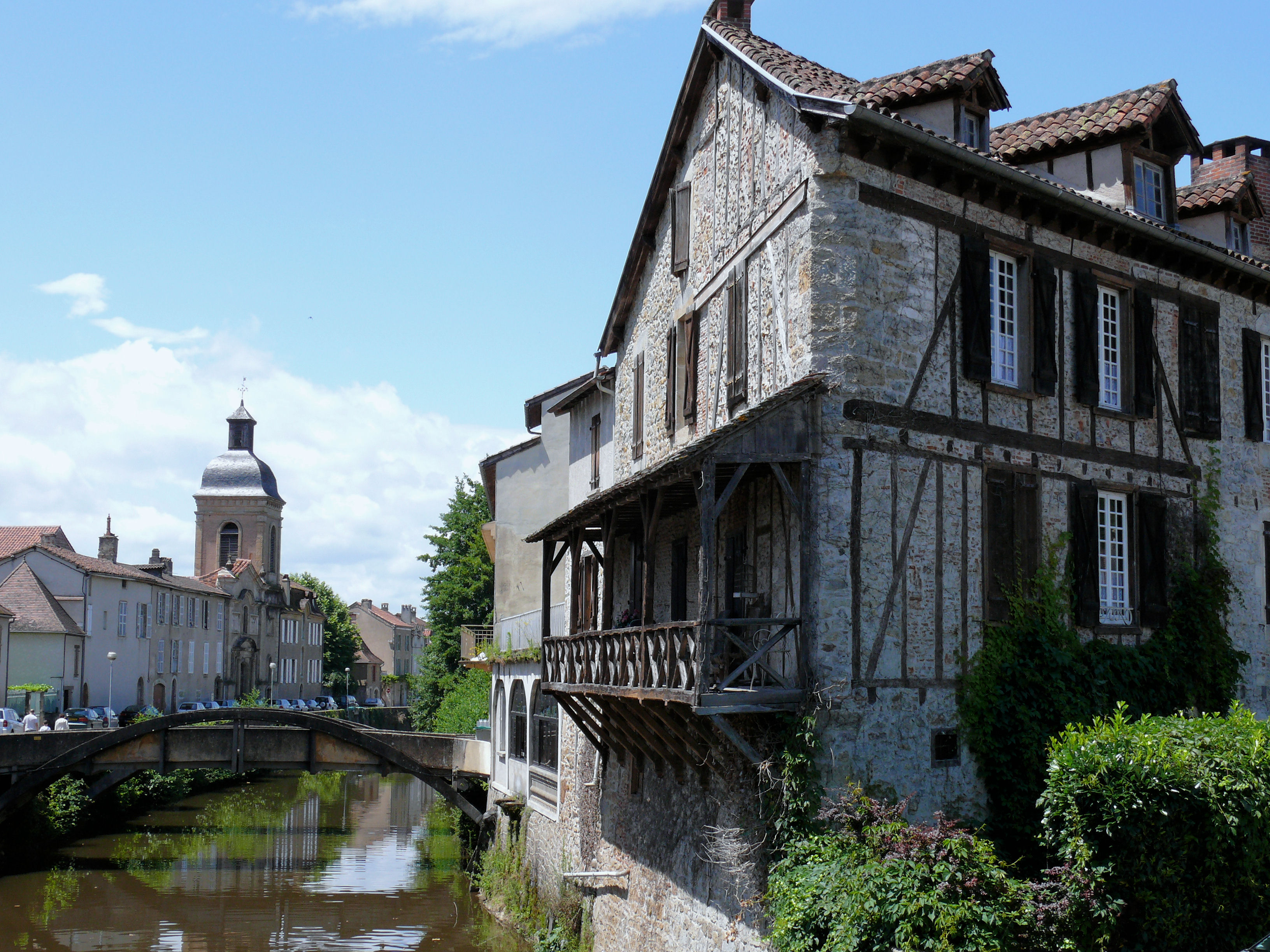 La Bave and the Quai des Récollets | |
 Coat of arms | |
Location of Saint-Céré  | |
 Saint-Céré  Saint-Céré | |
| Coordinates: 44°51′35″N 1°53′30″E | |
| Country | France |
| Region | Occitania |
| Department | Lot |
| Arrondissement | Figeac |
| Canton | Saint-Céré |
| Intercommunality | Causses et Vallée de la Dordogne |
| Government | |
| • Mayor (2020–2026) | Dominique Bizat |
| Area 1 | 11.33 km2 (4.37 sq mi) |
| Population | 3,414 |
| • Density | 300/km2 (780/sq mi) |
| Time zone | UTC+01:00 (CET) |
| • Summer (DST) | UTC+02:00 (CEST) |
| INSEE/Postal code | 46251 /46400 |
| Elevation | 141–523 m (463–1,716 ft) (avg. 152 m or 499 ft) |
| 1 French Land Register data, which excludes lakes, ponds, glaciers > 1 km2 (0.386 sq mi or 247 acres) and river estuaries. | |
Geography
Location
The town is located in the centre of a small metropolitan area, in the Quercy, northeast of the Causse de Gramat and west of Segala, between Lacapelle-Marival and Bretenoux, in the valley of the Bave, tributary of the Dordogne river, and on the northern edge of the Limargue. It is the city-centre of the urban unit of Saint-Céré.
Located at the crossroad of the routes to Limousin, Auvergne and Quercy, Saint-Céré is a sought after place to stay due to its location and an excellent point of departure for many walks and excursions in the Haut-Quercy.
Hydrography
The Bave river, a tributary of the Dordogne, flows through the town.
Geology and relief
The area of the commune is 1,133 hectares; its altitude varies from 141 to 523 meters.[4]
At the town hall, the altitude of Saint-Céré is 155 meters. It rises from 141 meters at Bave river to 523 meters in the southern part of the commune.
Climate
Saint-Céré has the distinction of being at the junction of the three types of temperate climates: there is a Temperate Oceanic climate, with Mediterranean and Continental influences, characterised by a dry and hot summer, a sunny autumn, a mild winter. In the shelter of the foothills of the Massif Central, the Vent d'Autan is here moderate.
Toponymy
Saint-Céré is based on the Christian hagiotoponym of Serenus of Marseille.[5]
During the French Revolution, the commune bore the name of Franc-Céré and Sen Céré (or Seu-Céré).[6]
In Occitan, the name of the municipality is Sant Seren.
Local culture and heritage
- La place du Mercadial, its fountain and the 15th century Consuls' House, which was declared a historic monument in 1991[7]
- L'hôtel de Puymule, 15th-century, was listed as a historical monument in 1929[8]
- L'hôtel de Miramon[9]
- La maison consulaire[10]
- Several wood-panelled houses
- Église Sainte-Spérie, dating from the 10th century, inscribed as a historical monument in 1979[11]
- Église des Récollets, 17th century, listed as a historic monument in 1973[12]
- Statue of Marshal Canrobert
- Statue of Charles Bourseul (1924) by Giovanni Pinotti Cipriani (also sculptor of the monument to the dead in the square of the Place de la République)
- Château de Montal, 14th-century, listed as a historical monument in 1909. The domain is partly located in the commune of Saint-Jean-Lespinasse.[13]
See also
References
- "Populations légales 2019". The National Institute of Statistics and Economic Studies. 29 December 2021.
- INSEE commune file
- http://www.st-cere.com/guides/St-Laurent-les-Tours.html Archived 2010-09-05 at the Wayback Machine
- "Répertoire Géographique des Communes 2011". public.opendatasoft.com. Retrieved 2019-07-17.
- Bazalgues, Gaston (2002). À la découverte des noms de lieux du Quercy. Toponymie lotoise (Éditions de la Bouriane et du Quercy ed.). Gourdon. p. 53. ISBN 2-910540-16-2.
- Des villages de Cassini aux communes d'aujourd'hui: Commune data sheet Saint-Céré, EHESS. (in French)
- Base Mérimée: Ancienne maison consulaire, Ministère français de la Culture. (in French)
- Base Mérimée: Ancien hôtel de Puymule, Ministère français de la Culture. (in French)
- Base Mérimée: Maison Louis XIII, Ministère français de la Culture. (in French)
- Base Mérimée: Ancienne maison consulaire, Ministère français de la Culture. (in French)
- Base Mérimée: Eglise et sa crypte de Sainte-Spérie, Ministère français de la Culture. (in French)
- Base Mérimée: Eglise des Récollets, Ministère français de la Culture. (in French)
- Base Mérimée: Domaine de Montal (également sur commune de Saint-Céré), Ministère français de la Culture. (in French)
| Wikimedia Commons has media related to Saint-Céré. |
Communes of the Lot department | |
|---|---|
|
Authority control | |
|---|---|
| General | |
| National libraries | |
На других языках
- [en] Saint-Céré
[es] Saint-Céré
Saint-Céré (en occitano Sant Seren) es una población y comuna francesa, situada en la región de Mediodía-Pirineos, departamento de Lot, en el distrito de Figeac y cantón de Saint-Céré.Другой контент может иметь иную лицензию. Перед использованием материалов сайта WikiSort.org внимательно изучите правила лицензирования конкретных элементов наполнения сайта.
WikiSort.org - проект по пересортировке и дополнению контента Википедии