world.wikisort.org - France
Auzat (French pronunciation: [ozat]; Languedocien: Ausat) is a commune in the Ariège department in the Occitanie region of south-western France.
Auzat | |
|---|---|
Commune | |
 The Rue des Pyrénées, in Auzat | |
Location of Auzat  | |
 Auzat  Auzat | |
| Coordinates: 42°46′02″N 1°28′51″E | |
| Country | France |
| Region | Occitania |
| Department | Ariège |
| Arrondissement | Foix |
| Canton | Sabarthès |
| Intercommunality | CC Haute-Ariège |
| Government | |
| • Mayor (2020–2026) | Abdel El Yacoubi[1] |
| Area 1 | 162.74 km2 (62.83 sq mi) |
| Population | 469 |
| • Density | 2.9/km2 (7.5/sq mi) |
| Time zone | UTC+01:00 (CET) |
| • Summer (DST) | UTC+02:00 (CEST) |
| INSEE/Postal code | 09030 /09220 |
| Elevation | 720–3,143 m (2,362–10,312 ft) (avg. 737 m or 2,418 ft) |
| 1 French Land Register data, which excludes lakes, ponds, glaciers > 1 km2 (0.386 sq mi or 247 acres) and river estuaries. | |
The inhabitants of the commune are known as Auzatois or Auzatoises.[3]
The commune has been awarded one flower by the National Council of Towns and Villages in Bloom in the Competition of cities and villages in Bloom.[4]
Geography

Auzat is located some 45 km south by south-west of Pamiers and 40 km north by north-west of Andorra la Vella. Its south-western border is the border between France and Spain and its south-eastern border is the border between France and Andorra. Access to the commune is by road D8 which branches from the D18 at Vicdessos and goes to the village then continues south to access the dam at Etang de Soulcem. Due to the extremely rugged terrain there is no access to Spain or Andorra from the commune. Its highest point is the Pica d'Estats (3143 m), which is located in the Montcalm Massif, exactly on the Spanish border.[5]
Many streams rise in the south of the commune and flow north in two parallel main streams - the Ruisseau de la Coume de Subra and the Ruisseau de Mounicou. The Ruisseau de la Coume de Subra joins the Ruisseau de l'Artigue flowing east to join the Ruisseau de Mounicou which continues north to the village where it becomes the Ruisseau de Vicdessos then continues east to join the Ariège at Tarascon-sur-Ariège. There are also many lakes in the south of the commune with the Etang de Soulcem being the largest.
Hamlets and places in the commune
- Emperrot
- L'Artigue
- Marc
- Saleix
- Olbier
- Artiès
- Mounicou
Neighbouring communes and villages
Places adjacent to Auzat | ||||||||||||||||
|---|---|---|---|---|---|---|---|---|---|---|---|---|---|---|---|---|
| ||||||||||||||||
Environment
The commune has a rich environment in terms of Wilderness and ecological potential but industrialization has left traces: in particular the disused Pechiney Aluminium Smelter (closed in 2003) left heavy environmental consequences.
The smelter was ranked 2 under Directive 96/82/EC (Seveso). The plant had an internal landfill site of 1.8 hectares located several kilometres from the smelter site at a place called Massada on the border with Vicdessos commune. This discharge area, as well as the groundwater and soil that supported the plant operations, are polluted by various pollutants including fluorides, cyanides, hydrocarbons, arsenic, aluminium, and barium.[6]
History

- Onost had the first group housing in the Middle Ages with the Church of Saint-Vincent of Onost mentioned in the 11th century
- Auzat village was founded in the 11th or 12th century. It was a village grouped around the present Rue du Fort and the Rue du Rocher
- 12th-15th centuries: domination by Montreal-de-Sos, castle of the Counts of Foix
- 1907: Construction of the Pechiney Smelter to manufacture ingots and billets of aluminum
- 1908: construction of a central hydroelectric station to supply electricity to the Pechiney smelter
- 1911: opening of the Tramway de Tarascon-sur-Ariège à Auzat
- 1939: The Catastrophe of Izourt - an avalanche that killed 28 people[7]
- 1990: Implementation of the Montcalm Water Company
- 2003: closure of the Pechiney smelter
- 2007: Opening of the House of heritage
- 2011: a new athletics stadium was inaugurated in the presence of President of the FFA, Bernard Amsalem
Administration

This list is incomplete; you can help by adding missing items. (April 2021) |
List of Successive Mayors[8]
| From | To | Name | Party | Position |
|---|---|---|---|---|
| 1867 | 1871 | Victorin Galy | General Councillor | |
| 1985 | 2014 | Bernard Piquemal | PS | General Councillor |
| 2014 | 2020 | Jean Pierre Ruffé | President of the Community of Communes | |
| 2020 | 2026 | Abdel El Yacoubi |
Twinning
Since 2003, the Auzat valley and Vicdessos have developed special links with Italy, especially with the Veneto and Friuli regions which were the origins of the victims of the Izourt Dam disaster in Auzat that had resulted in the deaths of 29 Italians and 3 Frenchmen on 24 March 1939. The Ricordate Association, with the support of elected officials, regularly organizes events and commemorations for the victims' families to honour their dead and to better understand the circumstances of the accident.[9]
Demography
In 2017 the commune had 488 inhabitants.
|
| ||||||||||||||||||||||||||||||||||||||||||||||||||||||||||||||||||||||||||||||||||||||||||||||||||||||||||||||||||
| Source: EHESS[10] and INSEE[11] | |||||||||||||||||||||||||||||||||||||||||||||||||||||||||||||||||||||||||||||||||||||||||||||||||||||||||||||||||||

Culture and heritage
Civil heritage
- The Chateau of Montreal-de-Sos is located on a rocky escarpment overlooking the hamlet of Olbier
- The Vicdessos Valley
- The Vicdessos Lakes
 A bridge on the GR 10 across the Ruisseau de Bassiès at 1590m
 The Etang de Canalbonne
 The Etang de Bassiès and Mérens horses
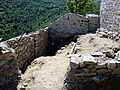 Inside the Chateau of Montreal-de-Sos
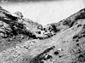 The Col du Saleich in 1882
 Auzat Bridge in 1882
 Mont Calm in 1882


Religious heritage
The commune has several religious buildings:
- The Cemetery Chapel has a Statue of Saint Bartholomew (15th century)
 which is registered as an historical object[12]
 - The Church of Auxat has three items that are registered as historical objects:
- The Church of Olbier has one item that is registered as an historical object:
- A Collection Plate (16th century)[16]
- A Collection Plate (16th century)
- The Church of Saleix has many items that are registered as historical objects:
- A Chalice (17th century)[17]
- A Tabernacle (18th century)[18]
- 2 Statues: Virgin and Child, Saint Joseph (18th century)[19]
- Group sculpture: Virgin of Pity (16th century)[20]
- A Collection Plate: the Annunciation (16th century)[21]
- A Collection Plate: Adam and Eve (16th century)[22]
- 2 Statues: Saint Roch, Saint John (18th century)[23]
- A Chandelier (19th century)[24]
- A Chalice (17th century)
Notable people linked to the commune
- Jean Sérafin, footballer
- Aimé Molinié, senator
See also
References
- "Répertoire national des élus: les maires". data.gouv.fr, Plateforme ouverte des données publiques françaises (in French). 2 December 2020.
- "Populations légales 2019". The National Institute of Statistics and Economic Studies. 29 December 2021.
- Inhabitants of Ariège (in French)
- Auzat in the Competition for Towns and Villages in Bloom Archived December 10, 2014, at the Wayback Machine (in French)
- Google Maps
- Note by ONG on the Robin Hood website entitled "The failures of Pechiney" dated 6 October 2003 (in French)
- Catastrophe of Izourt Archived 2014-07-14 at the Wayback Machine (in French)
- List of Mayors of France (in French)
- Izourt Dam disaster
- Des villages de Cassini aux communes d'aujourd'hui: Commune data sheet Auzat, EHESS. (in French)
- Population en historique depuis 1968, INSEE
- Ministry of Culture, Palissy PM09000055 Statue: Saint Bartholomew (in French)
- Ministry of Culture, Palissy PM09000047 Chandelier (in French)

- Ministry of Culture, Palissy PM09000046 Ciborium (in French)
- Ministry of Culture, Palissy PM09000045 Monstrance (in French)
- Ministry of Culture, Palissy PM09000855 Collection Plate (in French)
- Ministry of Culture, Palissy PM09000856 Chalice (in French)
- Ministry of Culture, Palissy PM09000054 Tabernacle (in French)
- Ministry of Culture, Palissy PM09000053 2 Statues: Virgin and Child, Saint Joseph (in French)
- Ministry of Culture, Palissy PM09000052 Group sculpture: Virgin of Pity (in French)
- Ministry of Culture, Palissy PM09000051 Collection Plate: the Annunciation (in French)
- Ministry of Culture, Palissy PM09000050 Collection Plate: Adam and Eve (in French)
- Ministry of Culture, Palissy PM09000049 2 Statues: Saint Roch, Saint John (in French)
- Ministry of Culture, Palissy PM09000048 Chandelier (in French)
External links
- Auzat official website (in French)
- Auzat on the old IGN website (in French)
- Vicdessos Valley official website (in French)
- The catastrophe of Izourt (in French)
- Ausat on the 1750 Cassini Map
На других языках
- [en] Auzat
[ru] Оза (коммуна)
Оза́ (фр. Auzat, окс. и кат. Ausat) — коммуна во Франции, находится в регионе Окситания, у границы с Испанией и Андоррой. Департамент коммуны — Арьеж. Входит в состав кантона Викдессо. Округ коммуны — Фуа.Другой контент может иметь иную лицензию. Перед использованием материалов сайта WikiSort.org внимательно изучите правила лицензирования конкретных элементов наполнения сайта.
WikiSort.org - проект по пересортировке и дополнению контента Википедии