world.wikisort.org - Finland
Kristinestad (Finland Swedish: [krisˈtiːneˌstɑːd], Sweden Swedish: [krɪsˈtîːnɛˌstɑːd];[7][8] Finnish: Kristiinankaupunki [ˈkristiːnɑŋˌkɑu̯puŋki]; Latin: Christinea) is a town and a municipality in Finland. It is located in the western part of Finland on the shore of the Bothnian Sea. The population of Kristinestad is 6,375 (31 December 2021)[9] and the municipality covers an area of 682.53 km2 (263.53 sq mi) (excluding sea areas) of which 14.66 km2 (5.66 sq mi) is inland water (1 January 2018).[2] The population density is 9.34/km2 (24.2/sq mi). The population is bilingual with a majority speaking Swedish (57%) and the minority Finnish (42%).[4] The town was chartered in 1649 by Per Brahe the Younger at Koppö island and is named for Queen Christina of Sweden.[1] Kristinestad is known for its old town with low wooden houses and narrow alleys. In April, 2011, Kristinestad became Finland's first Cittaslow community.
Kristinestad
Kristinestad – Kristiinankaupunki | |
|---|---|
Town | |
| Kristinestads stad Kristiinankaupungin kaupunki | |
 Kristinestad in 2019 | |
 Coat of arms | |
 Location of Kristinestad in Finland | |
| Coordinates: 62°16′N 021°21′E | |
| Country | |
| Region | Ostrobothnia |
| Sub-region | Suupohjan rannikkoseutu |
| Founded | 1649[1] |
| Named for | Christina of Sweden[1] |
| Government | |
| • Town manager | Mila Segervall |
| Area (2018-01-01)[2] | |
| • Total | 1,678.98 km2 (648.26 sq mi) |
| • Land | 682.53 km2 (263.53 sq mi) |
| • Water | 996.45 km2 (384.73 sq mi) |
| • Rank | 124th largest in Finland |
| Population (2021-12-31)[3] | |
| • Total | 6,375 |
| • Rank | 150th largest in Finland |
| • Density | 9.34/km2 (24.2/sq mi) |
| Population by native language | |
| • Swedish | 56.6% (official) |
| • Finnish | 42.2% |
| • Others | 1.2% |
| Population by age | |
| • 0 to 14 | 11.9% |
| • 15 to 64 | 51.4% |
| • 65 or older | 36.7% |
| Time zone | UTC+02:00 (EET) |
| • Summer (DST) | UTC+03:00 (EEST) |
| Municipal tax rate[6] | 21.5% |
| Website | www |
Geography
Climate
Kristinestad has a continental subarctic climate (Dfc).
| Climate data for Kristinestad | |||||||||||||
|---|---|---|---|---|---|---|---|---|---|---|---|---|---|
| Month | Jan | Feb | Mar | Apr | May | Jun | Jul | Aug | Sep | Oct | Nov | Dec | Year |
| Daily mean °C (°F) | −8 (18) |
−7.8 (18.0) |
−3.7 (25.3) |
1.9 (35.4) |
9 (48) |
14 (57) |
15.7 (60.3) |
13.8 (56.8) |
8.8 (47.8) |
4.0 (39.2) |
−1.3 (29.7) |
−5.6 (21.9) |
3.4 (38.1) |
| Average precipitation days | 10 | 8 | 9 | 8 | 7 | 8 | 11 | 11 | 11 | 11 | 11 | 11 | 116 |
| Source: http://www.yr.no/place/Finland/Western_Finland/Kristinestad~650770/statistics.html | |||||||||||||
International relations
Twin towns — Sister cities
Kristinestad is twinned with:
Gallery
 Ulrica Eleonora church in central Kristinestad.
 During twilight over the town bay and the silhouette.
 Summer market of Kristinestad in 1989.
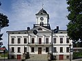 City Hall (1865)


See also
- Jakobstad
- Kaskinen
References
- Get to known the town: Urban traditions since 1649 – Visit Kristinestad
- "Area of Finnish Municipalities 1.1.2018" (PDF). National Land Survey of Finland. Retrieved 30 January 2018.
- "Preliminary population structure by area, 2021M01*-2021M12*". StatFin (in Finnish). Statistics Finland. Retrieved 2 February 2022.
- "Population according to language and the number of foreigners and land area km2 by area as of 31 December 2008". Statistics Finland's PX-Web databases. Statistics Finland. Retrieved 29 March 2009.
- "Population according to age (1-year) and sex by area and the regional division of each statistical reference year, 2003–2020". StatFin. Statistics Finland. Retrieved 2 May 2021.
- "List of municipal and parish tax rates in 2021" (PDF). Tax Administration of Finland. 1 December 2020. Retrieved 10 April 2021.
- "Svenska ortnamn i Finland - Institutet för de inhemska språken".
- "Kristinestad, Kristinestad - Finlandssvenska bebyggelsenamn".
- "Suomen virallinen tilasto (SVT): Väestön ennakkotilasto [verkkojulkaisu]" (in Finnish). Statistics Finland. Retrieved 15 March 2019.
External links
 Media related to Kristinestad at Wikimedia Commons
 Kristinestad travel guide from Wikivoyage
- Official website (in Swedish, Finnish, English, and German)
- Kristinestad 1649–1999. One of the best preserved wooden towns in Fenno-Scandinavia
Places adjacent to Kristinestad | ||||||||||||||||
|---|---|---|---|---|---|---|---|---|---|---|---|---|---|---|---|---|
| ||||||||||||||||
Municipalities of Ostrobothnia | ||
|---|---|---|
| Municipalities |  | |
| Former municipalities | ||
| ||
Authority control | |
|---|---|
| General |
|
| National libraries | |
| Other |
|
This Western Finland location article is a stub. You can help Wikipedia by expanding it. |
На других языках
[de] Kristinestad
Kristinestad (schwedisch), finnisch Kristiinankaupunki, ist eine Stadt in der westfinnischen Landschaft Österbotten. Sie liegt auf halber Strecke je rund 100 km zwischen den Städten Vaasa und Pori an der Schärenküste des Bottnischen Meerbusens. 57 % der 6404 Einwohner (Stand 31. Dezember 2020) sind Finnlandschweden, 42 % sprechen Finnisch als Muttersprache. Offiziell ist die Stadt zweisprachig.- [en] Kristinestad
[ru] Кристийнанкаупунки
Кри́стийнанкаупунки[1] (фин. Kristiinankaupunki), или Кристи́нестад (швед. Kristinestad) — город в провинции Похьянмаа в Финляндии. Иногда встречается вариант написания Кристиинанкаупунки.Другой контент может иметь иную лицензию. Перед использованием материалов сайта WikiSort.org внимательно изучите правила лицензирования конкретных элементов наполнения сайта.
WikiSort.org - проект по пересортировке и дополнению контента Википедии