world.wikisort.org - China
Jingbian County (simplified Chinese: 靖边县; traditional Chinese: 靖邊縣; pinyin: Jìngbiān Xiàn) is a county under the administration of Yulin City, in the northwest of Shaanxi Province, China, bordering Inner Mongolia to the north and northwest and flanked in the north by the Mu Us Desert. It has a land area of 4,975 km2 (1,921 sq mi), and a population of 384,100 in 2020.[1]
Jingbian County
靖边县 Tsingpien | |
|---|---|
County | |
 | |
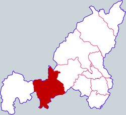 Jingbian in Yulin | |
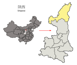 Yulin in Shaanxi | |
| Coordinates: 37°35′33″N 108°48′1″E | |
| Country | People's Republic of China |
| Province | Shaanxi |
| Prefecture-level city | Yulin |
| Area | |
| • Total | 4,975 km2 (1,921 sq mi) |
| Elevation | 1,339 m (4,393 ft) |
| Population (2020) | |
| • Total | 384,100 |
| • Density | 77/km2 (200/sq mi) |
| Time zone | UTC+8 (China Standard) |
| Postal code | 718500 |
| Website | www |
History
The county was first established as Bian County in 1731, although the area has been inhabited since the Paleolithic era. Ruins of the 5th century Hun capital Tongwancheng can be found in the county.[2]
Culture
The county is known for its paper-cutting art and Xintianyou folk music and its culture is described as a mix between Chinese and Mongolian.[2]
Economy
A large gas field is located in Jingbian, and it is a hub of the West–East Gas Pipeline network. There are also significant coal and rock salt reserves.[2]
Administrative divisions
As 2019, Jingbian County is in charge of one subdistrict and sixteen towns.[3]
- Subdistricts
- Zhangjiapan Subdistrict (张家畔街道) - it is upgraded from town.
- Towns
|
|
- Towns are upgraded from townships.
|
|
- Towns are established newly.
- Huanghaojie (黄蒿界镇)
- Former Townships are merged to other.
|
|
Transportation
- G20 Qingdao–Yinchuan Expressway
- G65 Baotou–Maoming Expressway
- Taiyuan-Zhongwei-Yinchuan Railway
References
- "2020年[榆林]靖边县最新常住户籍人口有多少和普查人口数据-红黑人口库2021年". www.hongheiku.com. Retrieved 2021-06-13.
- "靖边概况 | 靖边县". sfdot.ouchn.edu.cn. Retrieved 2021-06-13.
- "统计用区划代码 www.stats.gov.cn" (in Chinese). XZQH. Retrieved 2021-01-02.
External links
На других языках
- [en] Jingbian County
[ru] Цзинбянь
Цзинбя́нь (кит. упр. 靖边, пиньинь Jìngbiān) — уезд городского округа Юйлинь провинции Шэньси (КНР). Уезд назван по пограничному укреплению, существовавшему здесь во времена империи Мин.Другой контент может иметь иную лицензию. Перед использованием материалов сайта WikiSort.org внимательно изучите правила лицензирования конкретных элементов наполнения сайта.
WikiSort.org - проект по пересортировке и дополнению контента Википедии