world.wikisort.org - China
Huyi District (Chinese: 鄠邑区; pinyin: Hùyì Qū), formerly known as Hu County or Huxian (simplified Chinese: 户县; traditional Chinese: 戶縣, written as 鄠縣/鄠县 before 1964, pinyin: Hù Xiàn (same for both ways of writing)), is one of 11 urban districts of the prefecture-level city of Xi'an, the capital of Shaanxi Province, Northwest China. The district was approved to establish from the former Hu County (户县) by the Chinese State Council on November 24, 2016.[2] As of 2018, its population was 558,600.[3] The district borders the prefecture-level cities of Xianyang to the north and Ankang to the south and Chang'an District to the east.
This article needs additional citations for verification. (July 2014) |
This article may be expanded with text translated from the corresponding article in Chinese. (December 2008) Click [show] for important translation instructions.
|
Huyi
鄠邑区 | |||||||||||||||||||||||||||||||||||
|---|---|---|---|---|---|---|---|---|---|---|---|---|---|---|---|---|---|---|---|---|---|---|---|---|---|---|---|---|---|---|---|---|---|---|---|
District | |||||||||||||||||||||||||||||||||||
 | |||||||||||||||||||||||||||||||||||
| Coordinates: 34°06′47″N 108°36′22″E[1] | |||||||||||||||||||||||||||||||||||
| Country | People's Republic of China | ||||||||||||||||||||||||||||||||||
| Province | Shaanxi | ||||||||||||||||||||||||||||||||||
| Sub-provincial city | Xi'an | ||||||||||||||||||||||||||||||||||
| Area | |||||||||||||||||||||||||||||||||||
| • Total | 1,282 km2 (495 sq mi) | ||||||||||||||||||||||||||||||||||
| Population (2019) | |||||||||||||||||||||||||||||||||||
| • Total | 564,600 | ||||||||||||||||||||||||||||||||||
| • Density | 440/km2 (1,100/sq mi) | ||||||||||||||||||||||||||||||||||
| Time zone | UTC+8 (China Standard) | ||||||||||||||||||||||||||||||||||
| Postal code | 710300 | ||||||||||||||||||||||||||||||||||
| Area code | (0)029 | ||||||||||||||||||||||||||||||||||
| Xi'an district map |
| ||||||||||||||||||||||||||||||||||
| Website | www | ||||||||||||||||||||||||||||||||||
It has an area of 1,255 km2 (485 sq mi), and contains 11 towns and five townships.[citation needed] Towards its south the district is bordered by the Qin Mountains and to the north by the Weihe River. Thirty-six rivers run through the area, making the land very fertile. Fifty-five acres of land are arable and 52.4 acres of land are covered by forests. The region has an abundance of minerals such as gold, silver, copper, iron, limestone and marble.[citation needed]
In 2010 GDP reached 100 billion Yuan (about US$2000 per capita).[citation needed]
Climate
The district enjoys a warm tropical climate, free of extreme temperatures, with an average temperature of around 13.3 degrees Celsius (55 °F). The most pleasant months are in spring between March and May and September to November. The winters are cold but not excessively so, with an average temperature of -1 Celsius (30 °F) in January. The summers are warm and dry with most of the precipitation coming in the autumn.
Administrative divisions
As 2020, Huyi District is divided to 8 subdistricts and 6 towns.[4]
- Subdistricts
|
|
- Towns
|
|
Economy
This district is one of the main sources of Aggregata.
Herbs
There are 340 kinds of medicinal herbs that grow wild in the area including Iris, Aggregata, Bupleurum, Tianma, Honeysuckle, Fritillaria, and Schisandra.
Demographics
The district has a male population of 303,400 and female population of 274,600 (1.1 male:1 female). The majority of the district's population is rural at 477,400, while the urban population is 100,600 (roughly 86.45% and 16.55% respectively). The population density is 477 people per square kilometer. Population density in urban areas can reach as high as 3400 per square kilometer, and can be as low as 11 per square kilometer in rural areas. Han make up 99.88% of the population, although 21 other ethnic groups also live there.
Tourism
Tourist attractions
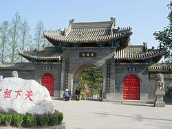
Huyi district is famous for a variety of tourist attractions. Tourists can enjoy the landscape of this region, especially in two national parks—Taiping National Forest Park and Zhuque National Forest Park, which offer a great view of mountains and waterfalls. It is also the home to two famous temples: Caotang Temple and Chongyang Palace, where Wang Chongyang, founder of Quanzhen School, practiced Taoism and where he was buried. It is said that great ancient Chinese poets such as Du Fu, Cen Shen, Su Shi, and Cheng Hao visited Meibei Lake, which lies to the west of the downtown area of Huyi District.
References
- Google (2014-07-02). "Huxian" (Map). Google Maps. Google. Retrieved 2014-07-02.
- 鄠邑区历史沿革 (in Simplified Chinese). xzqh.org. 2016-12-02. Retrieved 2019-07-19.
- 鄠邑区2018年国民经济和社会发展统计公报 (in Simplified Chinese). xahy.gov. 2019-04-26. Retrieved 2019-07-19.
- 2020年统计用区划代码(高陵区) (in Chinese). National Bureau of Statistics of China. 2020. Archived from the original on 2020-11-30. Retrieved 2020-11-30.
External links
На других языках
[de] Huyi
Huyi (chinesisch .mw-parser-output .Hans{font-size:110%}鄠邑区, Pinyin Hùyì Qū, ehemals Kreis Hu, chinesisch 户县, Pinyin Hù Xiàn) ist ein Stadtbezirk der Stadt Xi’an in der nordwestchinesischen Provinz Shaanxi. Huyi hat eine Fläche von 1.249 km² und 576.000 Einwohner (Stand: Zensus 2020).[1] Sein Hauptort ist das Straßenviertel Ganting (甘亭街道).- [en] Huyi District
[ru] Хуи (Сиань)
Хуи́ (кит. упр. 鄠邑, пиньинь Hùyì) — район городского подчинения города субпровинциального значения Сиань провинции Шэньси (КНР). Название района означает «местность Ху» и происходит от того, что при династии Ся в этих местах жили представители рода Ху.Другой контент может иметь иную лицензию. Перед использованием материалов сайта WikiSort.org внимательно изучите правила лицензирования конкретных элементов наполнения сайта.
WikiSort.org - проект по пересортировке и дополнению контента Википедии

