world.wikisort.org - Canada
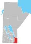
Shoal Lake 40 is a First Nations reserve straddling the border of Manitoba and Ontario on the shores of Shoal Lake. It is one of the reserves of the Shoal Lake 40 First Nation.
Shoal Lake 40 | |
|---|---|
Indian reserve | |
| Shoal Lake Indian Reserve No. 40 | |
 Shoal Lake 40 | |
| Coordinates: 49°37′N 95°09′W | |
| Country | |
| Provinces | |
| District / Division | Kenora / Division 1 |
| First Nation | Shoal Lake 40 |
| Area | |
| • Land | 26.21 km2 (10.12 sq mi) |
| Population | |
| • Total | 101 |
| • Density | 3.9/km2 (10/sq mi) |
| Website | www.sl40.ca |
References
- "Shoal Lake (part) 40 census profile". 2011 Census of Population. Statistics Canada. Retrieved 22 June 2015.
- "Shoal Lake (part) 40 census profile". 2011 Census of Population. Statistics Canada. Retrieved 22 June 2015.
Текст в блоке "Читать" взят с сайта "Википедия" и доступен по лицензии Creative Commons Attribution-ShareAlike; в отдельных случаях могут действовать дополнительные условия.
Другой контент может иметь иную лицензию. Перед использованием материалов сайта WikiSort.org внимательно изучите правила лицензирования конкретных элементов наполнения сайта.
Другой контент может иметь иную лицензию. Перед использованием материалов сайта WikiSort.org внимательно изучите правила лицензирования конкретных элементов наполнения сайта.
2019-2025
WikiSort.org - проект по пересортировке и дополнению контента Википедии
WikiSort.org - проект по пересортировке и дополнению контента Википедии

