world.wikisort.org - Canada
Sioux Narrows-Nestor Falls is a township in the Canadian province of Ontario, located in the Kenora District. It is located on the eastern shores of Lake of the Woods along Ontario Highway 71.
Sioux Narrows-Nestor Falls | |
|---|---|
Township (single-tier) | |
| Township of Sioux Narrows-Nestor Falls | |
 Sioux Narrows Bridge | |
 Sioux Narrows-Nestor Falls | |
| Coordinates: 49°24′N 94°05′W | |
| Country | Canada |
| Province | Ontario |
| District | Kenora |
| Settled | 1880s |
| Formed | January 1, 2001 |
| Government | |
| • Mayor | Norbert Dufresne |
| • Federal riding | Kenora |
| • Prov. riding | Kenora—Rainy River |
| Area | |
| • Land | 1,223.12 km2 (472.25 sq mi) |
| Population (2016)[1] | |
| • Total | 567 |
| • Density | 0.5/km2 (1/sq mi) |
| Time zone | UTC-6 (CST) |
| • Summer (DST) | UTC-5 (CDT) |
| Postal Code FSA | P0X |
| Area code(s) | 807 |
| Website | www |
The township was formed in 2001 by amalgamating the formerly incorporated Township of Sioux Narrows with portions of Unorganized Kenora District, including the community of Nestor Falls. The township had a population of 720 in the Canada 2011 Census.
Communities
Sioux Narrows is a small resort community located on the shores of Lake of the Woods where Highway 71 crosses the eponymous narrows between Whitefish and Regina Bay. There are about 300 permanent residents, and about double that in the summer time when cottagers from Ontario, Manitoba, and the United States come for vacation. Tourism is the primary industry, with many resorts in the nearby vicinity.
In the mid-18th century, an Ojibwa-Cree alliance is said to have defeated an invading party of Sioux at a narrows here on the lake. Sioux Narrows is named in recognition of that event. The Sioux Narrows Bridge, a historic structure on Highway 71 which was reconstructed in 2007, overlooks the site of the battle.[2]
Nestor Falls, located along Highway 71 at Sabaskong Bay on Lake of the Woods, held the status of designated place in the Canada 2006 Census, and has a population of 290. The settlement was founded in the early 20th century by a certain Mr. Nestor who started logging operations and used the natural waterfall there to transport the logs to Lake of the Woods.[2]
 Town centre of Sioux Narrows
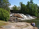 Nestor Falls


History
The area was originally home to Ojibway and Cree indigenous people. In the 18th century, Lake of the Woods began to be exploited by European fur traders as a good source for fur and it became part of an established trade route from the Rainy River to Rat Portage. The main trading posts were set up at Rainy River and Fort Frances, but circa 1804, an outpost was also established on Whitefish Lake (now known as Regina Bay, directly east of Sioux Narrows) by the Northwest Company.[3]
In the 1820s, the area was surveyed in order to determine the international border between the United States and British North America. But further development was limited since the Ojibway restricted European travelers only to the regular trade routes. In 1873, the Dominion of Canada signed Treaty 3, in which the Ojibway ceded vast tracts of territory to the Government of Canada. This permitted the first wave of settlers to arrive in the late 1870s or early 1880s. The construction of the Canadian Pacific Railway in 1881 further accelerated exploration, settlement, logging, and mining. The outpost on Whitefish Lake, since 1821 owned by the Hudson's Bay Company, was taken over by a private entrepreneur in the 1890s and operated until 1932.[4]
In 1895, a gold mine opened on Regina Bay, employing about eighty-five men and led to the formation of a settlement with a schoolhouse, miner's residences and a community hall. The mine was fully operational only until 1900 and thereafter operated intermittently. During that period until 1935, settlement remained sporadic and isolated, heavily dependent on the cyclical presence of mining and logging camps, and only accessible by boat or winter roads. The construction of what is now known as Ontario Highway 71 in the 1930s resulted in permanent communities and opened the area to a booming outdoor tourism industry.[4] In the late 1930s the Nestor Falls Post Office was merged with the Kakagi Lake Post Office and placed five miles south of Dalseg's store to accommodate commercial shipping trucks and buses travelling on the new highway.[5]
Demographics
In the 2021 Census of Population conducted by Statistics Canada, Sioux Narrows-Nestor Falls had a population of 727 living in 330 of its 1,061 total private dwellings, a change of 28.2% from its 2016 population of 567. With a land area of 1,215.8 km2 (469.4 sq mi), it had a population density of 0.6/km2 (1.5/sq mi) in 2021.[6]
| 2016 | 2011 | |
|---|---|---|
| Population | 567 (-21.3% from 2011) | 720 (7.1% from 2006) |
| Land area | 1,223.12 km2 (472.25 sq mi) | 1,222.43 km2 (471.98 sq mi) |
| Population density | 0.5/km2 (1.3/sq mi) | 0.6/km2 (1.6/sq mi) |
| Median age | 57.7 (M: 58.4, F: 57.3) | 52.7 (M: 52.0, F: 53.5) |
| Total private dwellings | 797 | 1044 |
| Median household income | $70,400 |
- Population in 2011: 720
- Population in 2006: 672
- Population in 2001: 577
- Population total in 1996: 794
- Sioux Narrows (township): 430
- Population in 1991:
- Sioux Narrows (township): 390
See also
- List of townships in Ontario
References
- "Sioux Narrows-Nestor Falls census profile". 2016 Census of Population. Statistics Canada. Retrieved 2018-04-18.
- "History". Sioux Narrows-Nestor Falls. Retrieved 2011-05-20.
- "Fur Trading Posts". Sioux Narrows-Nestor Falls. Retrieved 2011-05-20.
- "Early Settlement". Sioux Narrows-Nestor Falls. Retrieved 2011-05-20.
- "History of Young's Wilderness Camp" <http://www.youngswildernesscamp.com/history.htm>
- "Population and dwelling counts: Canada, provinces and territories, census divisions and census subdivisions (municipalities), Ontario". Statistics Canada. February 9, 2022. Retrieved April 2, 2022.
- "2016 Community Profiles". 2016 Canadian Census. Statistics Canada. August 12, 2021. Retrieved 2018-04-18.
- "2011 Community Profiles". 2011 Canadian Census. Statistics Canada. March 21, 2019. Retrieved 2012-04-03.
- "2006 Community Profiles". 2006 Canadian Census. Statistics Canada. August 20, 2019.
- "2001 Community Profiles". 2001 Canadian Census. Statistics Canada. July 18, 2021.
- Statistics Canada: Canada 1996 Census
External links
| Wikimedia Commons has media related to Sioux Narrows-Nestor Falls. |
Places adjacent to Sioux Narrows-Nestor Falls | ||||||||||||||||
|---|---|---|---|---|---|---|---|---|---|---|---|---|---|---|---|---|
| ||||||||||||||||
Kenora District, Ontario | ||
|---|---|---|
| Cities |
|  |
| Towns |
| |
| Townships |
| |
| First Nations |
| |
| Indian reserves |
| |
| Indian settlements |
| |
| Unorganized areas |
| |
| Local services boards |
| |
| Unincorporated communities |
| |
| ||
Другой контент может иметь иную лицензию. Перед использованием материалов сайта WikiSort.org внимательно изучите правила лицензирования конкретных элементов наполнения сайта.
WikiSort.org - проект по пересортировке и дополнению контента Википедии