world.wikisort.org - Canada
Medstead (2016 population: 130) is a village in the Canadian province of Saskatchewan within the Rural Municipality of Medstead No. 497 and Census Division No. 16.
Village of Medstead | |
|---|---|
Village | |
 Location of Medstead in Saskatchewan  Medstead, Saskatchewan (Canada) | |
| Coordinates: 53.305°N 108.043°W | |
| Country | Canada |
| Province | Saskatchewan |
| Region | Saskatchewan |
| Census division | 16 |
| Rural Municipality | Medstead |
| Post office Founded | N/A |
| Incorporated (Village) | N/A |
| Incorporated (Town) | N/A |
| Government | |
| • Mayor | Robert Bonsan |
| • Administrator | Debbie A. Arsenault |
| • Governing body | Medstead Village Council |
| Area | |
| • Total | 0.67 km2 (0.26 sq mi) |
| Population (2006) | |
| • Total | 148 |
| • Density | 213.4/km2 (553/sq mi) |
| Time zone | CST |
| Postal code | S0M 1W0 |
| Area code | 306 |
| Highways | Highway |
| [1][2][3][4] | |
History
Medstead incorporated as a village on April 23, 1931.[5]
Demographics
In the 2021 Census of Population conducted by Statistics Canada, Medstead had a population of 121 living in 60 of its 73 total private dwellings, a change of -6.9% from its 2016 population of 130. With a land area of 0.65 km2 (0.25 sq mi), it had a population density of 186.2/km2 (482.1/sq mi) in 2021.[8]
In the 2016 Census of Population, the Village of Medstead recorded a population of 130 living in 65 of its 72 total private dwellings, a 7.7% change from its 2011 population of 120. With a land area of 0.67 km2 (0.26 sq mi), it had a population density of 194.0/km2 (502.5/sq mi) in 2016.[9]
See also
- List of communities in Saskatchewan
- Villages of Saskatchewan
References
- National Archives, Archivia Net, Post Offices and Postmasters, archived from the original on October 6, 2006
- Government of Saskatchewan, MRD Home, Municipal Directory System, archived from the original on November 21, 2008
- Canadian Textiles Institute. (2005), CTI Determine your provincial constituency, archived from the original on 2007-09-11
- Commissioner of Canada Elections, Chief Electoral Officer of Canada (2005), Elections Canada On-line, archived from the original on April 21, 2007
- "Urban Municipality Incorporations". Saskatchewan Ministry of Government Relations. Archived from the original on October 15, 2014. Retrieved June 1, 2020.
- "Saskatchewan Census Population" (PDF). Saskatchewan Bureau of Statistics. Archived from the original (PDF) on September 24, 2015. Retrieved May 31, 2020.
- "Saskatchewan Census Population". Saskatchewan Bureau of Statistics. Retrieved May 31, 2020.
- "Population and dwelling counts: Canada, provinces and territories, census divisions and census subdivisions (municipalities), Saskatchewan". Statistics Canada. February 9, 2022. Retrieved April 1, 2022.
- "Population and dwelling counts, for Canada, provinces and territories, and census subdivisions (municipalities), 2016 and 2011 censuses – 100% data (Saskatchewan)". Statistics Canada. February 8, 2017. Retrieved May 30, 2020.
Subdivisions of Saskatchewan | |
|---|---|
| Subdivisions |
|
| Communities |
|
| Cities | |
| Villages |
|
| Topics |
|
| |
Division No. 16, Saskatchewan | ||
|---|---|---|
| Cities | 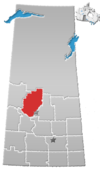 | |
| Towns |
| |
| Villages | ||
| Resort villages |
| |
| Rural municipalities |
| |
| Crown colonies |
| |
| First Nations |
| |
| Indian reserves |
| |
| Unorganized areas |
| |
| Unincorporated communities | ||
| ||
Другой контент может иметь иную лицензию. Перед использованием материалов сайта WikiSort.org внимательно изучите правила лицензирования конкретных элементов наполнения сайта.
WikiSort.org - проект по пересортировке и дополнению контента Википедии