world.wikisort.org - Canada
Hope is a district municipality at the confluence of the Fraser and Coquihalla rivers in the province of British Columbia, Canada. Hope is at the eastern end of both the Fraser Valley and the Lower Mainland region, and is at the southern end of the Fraser Canyon. To the east, over the Cascade Mountains, is the Interior region, beginning with the Similkameen Country on the farther side of the Allison Pass in Manning Park. Located 154 kilometres (96 mi) east of Vancouver, Hope is at the southern terminus of the Coquihalla Highway and the western terminus of the Crowsnest Highway, locally known as the Hope-Princeton (Highways 5 and 3, respectively), where they merge with the Trans-Canada Highway (Highway 1). Hope is at the eastern terminus of Highway 7. As it lies at the eastern end of the Fraser Valley in the windward Cascade foothills, the town gets very high amounts of rain and cloud cover – particularly throughout the autumn and winter.
This article uses bare URLs, which are uninformative and vulnerable to link rot. (August 2022) |
Parts of this article (those related to Nestlé Waters has changed hands. Also, article mentions a second annual festival held several years ago. And could somebody please make this article sound less like a tourism department press release) need to be updated. (September 2021) |
Hope | |
|---|---|
District municipality | |
| District of Hope[1] | |
 Municipal building and street clock with Memorial Park in background | |
 Flag  Seal | |
 Location of Hope in British Columbia  Location of Hope in Fraser Valley Regional District | |
| Coordinates: 49°23′09″N 121°26′31″W | |
| Country | Canada |
| Province | British Columbia |
| Regional district | Fraser Valley |
| Established | 1848 |
| Government | |
| • Mayor | Peter Robb |
| Area | |
| • Total | 40.95 km2 (15.81 sq mi) |
| Elevation | 41 m (135 ft) |
| Population (2016) | |
| • Total | 6,181 |
| • Density | 151.0/km2 (391/sq mi) |
| Time zone | UTC-8 (Pacific Standard Time) |
| • Summer (DST) | UTC-7 (Pacific Daylight Time) |
| Area code | 604 / 778 / 236 |
| Highways | |
| Website | hope |
Hope is a member municipality of the Fraser Valley Regional District which provides certain municipal services to unincorporated settlements and rural areas.
The District of Hope includes Hope[2] (the previous Town of Hope)[3] and surrounding areas, including the communities of Kawkawa Lake,[4] Silver Creek,[5] Flood, and Lake of the Woods.[6][7]
History
The Stó:lō have lived in the Fraser Valley since 8,000 to 10,000 years ago.
In late 1782, a smallpox epidemic among the Stó:lō killed thousands – an estimated two-thirds of the population.
Explorer Simon Fraser arrived in what is now Hope in 1808, and the Hudson's Bay Company created the Fort Hope trading post in 1848. The area was transformed by the Fraser Canyon Gold Rush, beginning in 1858. The following year Governor James Douglas laid out the Fort Hope town site. Hope became part of the new British colony of British Columbia when it was created on 2 August 1858. Along with the rest of British Columbia, Hope became part of Canada in 1871.
Late in 1859, Reverend Alexander St. David Francis Pringle arrived in Hope, and on 1 December of that year, founded the first library on the British Columbia mainland. Within two years, he also founded the Christ Church Anglican church, the oldest church on the British Columbia mainland that still holds services on its original site. It is a National Historic Site of Canada.[8][9]
Hope incorporated as a village on 6 April 1929, became a town on 1 January 1965, and was reincorporated as a District Municipality named the District of Hope on 7 December 1992.[10]
Naming
Fort Hope was established in 1848–49 by Henry Newsham Peers.[11] He discovered a route through the mountains that did not dip below the 49th parallel, which had become the American border. Thus, the hope that his route would be workable was fulfilled.[12]: 115
World War II
During World War II an internment camp for Japanese Canadians was set up near Hope at Tashme, now known as Sunshine Valley, just beyond the 100-mile exclusion zone from the coast.
Recent history
In 2011, the metal Kawkawa Bridge was demolished; previously, it was featured in the 1982 Rambo film, First Blood.[13][14] In 2020, a wood carved statue of Sylvester Stallone character John Rambo was erected in Hope.[15]
Geography


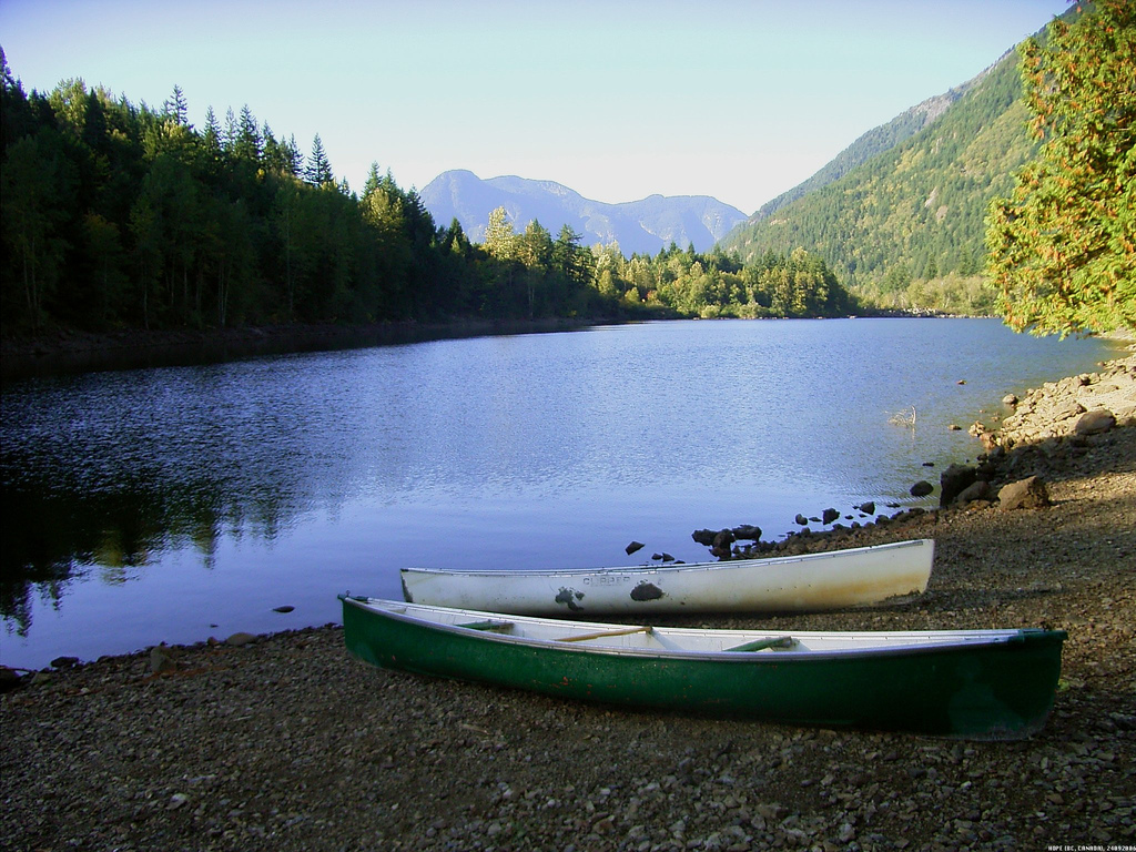
Hope is at the easternmost point of British Columbia's lower mainland area and is usually considered to be part of the Fraser Canyon area or "eastern Fraser Valley" as "Lower Mainland" is commonly understood as synonymous with "greater Vancouver". There are relatively significant peaks to the north, east, and south of the townsite. Only to the west can flat land be seen, and that view is dominated by the broad lower reaches of the Fraser River. The segment from Lytton to Hope separates the Cascade Mountains and Coast Mountains, thereby forming the lower part of the Fraser Canyon, which begins far upriver near Williams Lake. At Hope, the river enters a broad flood plain extending 130 kilometres (81 mi) to the coast and Vancouver. The Coquihalla and Sumallo Rivers and Silverhope Creek rise in the Cascade Mountains northeast and southeast and south of Hope, respectively, and empty into the Fraser River. The Skagit River begins south of Hope, across a low pass from the head of the Silverhope valley, which is the access to the Canadian shoreline of Ross Lake.

Climate
Hope has an oceanic climate (Köppen climate classification Cfb) with warm summers and moderately cold winters. Hope has a very cloudy climate for most of the year, with the cloudiest month December averaging only 4.4 monthly sunshine hours or 1.7% of possible sunshine. Late summer is the sunniest time of the year.
| Climate data for Hope Airport, 1981–2010 normals, extremes 1910–present[lower-alpha 1] | |||||||||||||
|---|---|---|---|---|---|---|---|---|---|---|---|---|---|
| Month | Jan | Feb | Mar | Apr | May | Jun | Jul | Aug | Sep | Oct | Nov | Dec | Year |
| Record high °C (°F) | 15.0 (59.0) |
19.4 (66.9) |
25.1 (77.2) |
32.2 (90.0) |
38.4 (101.1) |
41.4 (106.5) |
40.6 (105.1) |
39.1 (102.4) |
38.3 (100.9) |
30.3 (86.5) |
18.9 (66.0) |
16.1 (61.0) |
41.4 (106.5) |
| Average high °C (°F) | 4.7 (40.5) |
7.0 (44.6) |
12.1 (53.8) |
15.1 (59.2) |
18.6 (65.5) |
20.9 (69.6) |
23.6 (74.5) |
24.8 (76.6) |
21.4 (70.5) |
14.5 (58.1) |
7.1 (44.8) |
3.5 (38.3) |
14.4 (57.9) |
| Daily mean °C (°F) | 2.1 (35.8) |
3.6 (38.5) |
7.4 (45.3) |
10.1 (50.2) |
13.5 (56.3) |
16.0 (60.8) |
18.2 (64.8) |
19.0 (66.2) |
15.9 (60.6) |
10.5 (50.9) |
4.6 (40.3) |
1.2 (34.2) |
10.2 (50.4) |
| Average low °C (°F) | −0.4 (31.3) |
0.3 (32.5) |
2.6 (36.7) |
5.0 (41.0) |
8.4 (47.1) |
11.0 (51.8) |
12.8 (55.0) |
13.2 (55.8) |
10.3 (50.5) |
6.4 (43.5) |
2.1 (35.8) |
−1.0 (30.2) |
5.9 (42.6) |
| Record low °C (°F) | −25.0 (−13.0) |
−23.3 (−9.9) |
−16.7 (1.9) |
−5.6 (21.9) |
−2.8 (27.0) |
1.1 (34.0) |
3.3 (37.9) |
1.1 (34.0) |
−1.1 (30.0) |
−11.2 (11.8) |
−21.4 (−6.5) |
−24.4 (−11.9) |
−25.0 (−13.0) |
| Average precipitation mm (inches) | 290.5 (11.44) |
201.1 (7.92) |
159.0 (6.26) |
172.8 (6.80) |
112.0 (4.41) |
93.8 (3.69) |
77.8 (3.06) |
49.1 (1.93) |
97.0 (3.82) |
218.6 (8.61) |
352.5 (13.88) |
219.0 (8.62) |
2,043.3 (80.44) |
| Average rainfall mm (inches) | 265.9 (10.47) |
182.1 (7.17) |
154.3 (6.07) |
171.7 (6.76) |
112.0 (4.41) |
93.8 (3.69) |
77.8 (3.06) |
49.1 (1.93) |
97.0 (3.82) |
217.4 (8.56) |
339.0 (13.35) |
195.2 (7.69) |
1,955.2 (76.98) |
| Average snowfall cm (inches) | 27.9 (11.0) |
24.9 (9.8) |
5.1 (2.0) |
1.0 (0.4) |
0 (0) |
0 (0) |
0 (0) |
0 (0) |
0 (0) |
1.3 (0.5) |
14.3 (5.6) |
29.0 (11.4) |
103.5 (40.7) |
| Average precipitation days (≥ 0.2 mm) | 18.9 | 15.9 | 17.5 | 18.2 | 16.3 | 13.9 | 10.5 | 8.1 | 10.3 | 15.7 | 21.6 | 17.7 | 184.6 |
| Average rainy days (≥ 0.2 mm) | 16.7 | 13.7 | 17.2 | 18.2 | 16.3 | 13.9 | 10.5 | 8.1 | 10.2 | 15.6 | 20.8 | 14.9 | 176.1 |
| Average snowy days (≥ 0.2 cm) | 5.6 | 4.0 | 1.4 | 0.5 | 0 | 0 | 0 | 0 | 0 | 0.2 | 2.9 | 6.3 | 20.9 |
| Average relative humidity (%) | 77.1 | 68.0 | 57.2 | 56.5 | 57.6 | 59.4 | 58.5 | 55.0 | 55.7 | 68.8 | 80.2 | 78.0 | 64.3 |
| Mean monthly sunshine hours | 13.2 | 56.3 | 114.7 | 144.6 | 185.4 | 194.6 | 236.2 | 251.8 | 188.7 | 96.9 | 19.6 | 4.4 | 1,506.4 |
| Percent possible sunshine | 4.9 | 19.8 | 31.2 | 35.2 | 39.1 | 40.1 | 48.2 | 56.4 | 49.7 | 28.9 | 7.1 | 1.7 | 30.2 |
| Source: Environment Canada[16][17] | |||||||||||||
Demographics
In the 2021 Census of Population conducted by Statistics Canada, Hope had a population of 6,686 living in 2,939 of its 3,243 total private dwellings, a change of 8.2% from its 2016 population of 6,181. With a land area of 40.87 km2 (15.78 sq mi), it had a population density of 163.6/km2 (423.7/sq mi) in 2021.[18]
Economy
Hope's labour force works in a variety of industries. Almost 50 percent of the labour force is involved in four main industries: accommodation and food services (17.1 percent), health care and social assistance (12.8 percent), retail trade (10.3 percent), and transportation and warehousing (8 percent) (2006 data).[19]
One of the town's largest employers is Nestlé Waters. Nestlé, the world's biggest bottler of water, packages more than 300 million litres of water from Hope aquifers annually. Nestlé pays C$675 to the provincial government for this quantity of water (C$2.25 per million litres). The Nestlé bottling plant employs approximately 75 people.[20]
Economic planning
Hope's economic development planning is rooted in the community's strategic location, telecommunications infrastructure (high-speed internet), and strong support for new development and redevelopment. The 2014 Economic Profile identifies several sectors as significant areas of opportunity within the local economy:[21]
- Tourism: including development of tourism products attractive to the primary market coming from the west.
- Virtual commuters: professionals able to serve their clientele from off-site locations, such as consultants, photographers, graphic designers, and software developers.
- Natural resources: sustainable and responsible development of natural resource industries.
- Lifestyle manufacturing or services: such as coffee roasters, sustainable agriculture, micro-brewery, and other clean water-based industries.
- "Gap" retailers: independent, entrepreneurial retailers who can deliver niche services for local customers and travellers.
In addition, the Revitalization Tax Exemption Bylaw, adopted by the Hope District Council in 2013,[21] encourages property owners who develop or redevelop their properties to apply for financial incentives in the form of tax relief.
Arts and culture

Chainsaw wood carving
Hope holds chainsaw wood carving competitions and exhibitions. From 4 to 7 September 2008 the Second Annual Hope Chainsaw Carving Competition took place.[8]: 24 Chainsaw wood carvings are displayed and exhibited throughout the downtown core of Hope. Memorial Park in downtown Hope has a display of chainsaw wood carvings. Hope is home to carver Pete Ryan, who made a number of the chainsaw wood carvings exhibited in downtown Hope.[8]: 25
Hope Arts Gallery
The Hope Arts Gallery exhibits and sells a variety of art by local artists.[22] It is located in downtown Hope and has several rooms displaying sculpture, pottery, paintings and drawings, jewellery, fabric arts, basketry, cards and gifts, and photography. The gallery is run by volunteers from the Hope Arts Guild. The gallery presents ART WALK, a self-guided tour to art and chainsaw wood carvings in Hope.
Hope Brigade Days
One of Hope's largest events of the year is Hope Brigade Days, which occurs the weekend after Labour Day every September. Events include a parade, fireworks display, midway, chainsaw carving competition, demolition derby, kids' carnival, and 4x4 racing.[23]
Attractions
Hope Museum
The Hope Museum shows the history, culture and heritage of Hope. In downtown Hope, together with the Hope Visitor Centre, the Hope Museum is open year-round. Exhibits include First Nations culture, early Fort Hope, the Fraser Canyon Gold Rush, the Kettle Valley Railway, pioneer life, logging, and mining.[8]: 9 [24]
Hope Recreation Complex
The Hope Recreation Complex includes a library, pool, arena, and fitness centre. The Hope and District Recreation Complex is run by the Fraser Valley Regional District.[25]
Hope Slide
The Hope Slide was one of the largest landslides ever recorded in Canada. It occurred in the morning hours of 9 January 1965, near Hope, killing four people. A viewing site showing the Hope Slide is approximately a 15-minute drive east of Hope on Highway 3.[8]: 41 [26]
Memorial Park and Friendship Garden
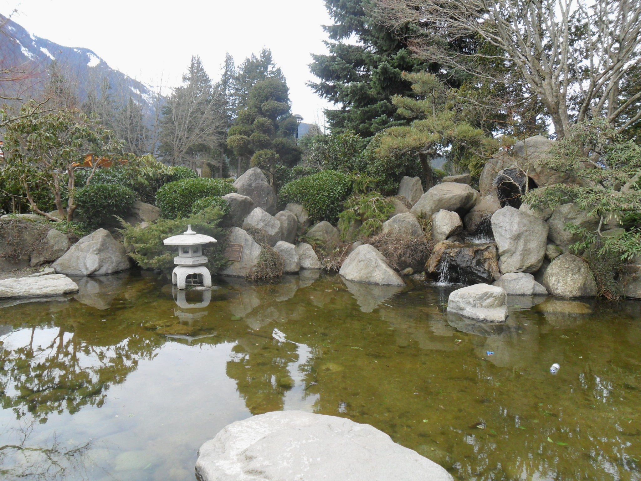
Immediately adjacent to the District Hall in Hope is a Japanese garden called the Friendship Garden, dedicated to the Japanese-Canadians who were interned nearby at Tashme during World War II.[8]: 26 It was built by local Japanese-Canadians and presented to Hope on 27 July 1991.[27] Men from that camp were employed during the war building the Hope-Princeton Highway.
Hope Memorial Park, adjacent to the District Hall and Friendship Garden, is the site of a concert series on Sunday afternoons in July and August.[8]: 27
Memorial Park was granted to the then-village of Hope in 1932 by the province of British Columbia. It occupies roughly 7 acres (28,000 m2) in the heart of the town.
Othello Tunnels
Othello Tunnels is the popular name for the main human-made features of Coquihalla Canyon Provincial Park, east of Hope along the canyon of the Coquihalla River and a decommissioned railway grade, now a walking trail, leading eventually to Coquihalla Pass. Originally part of the Kettle Valley Railway, five tunnels and a series of bridges give views of the Coquihalla River as it passes through the river's narrow gorge.[8]: 37 [28]
There are two main options for hikers to explore Othello Tunnels. The Othello Tunnels portion of Kettle Valley Trail, 4 km to-and-back, is stroller-friendly and wheelchair-accessible. The Hope-Nicola Valley Trail Loop, a 5.5 km loop hiking trail, is relatively well-maintained but not accessible, nor recommended for people with mobility issues.[29]
Sports

Curling
The Hope Curling Club is near the Hope Recreation Complex. The club sponsors bonspiels such as the Men's Bonspiel every January, and the Mixed Curling Bonspiel.[30]
Golf
Hope has a golf course and club on the banks of the Coquihalla River.
Hope Icebreakers Junior Hockey Club
The Hope Icebreakers were a Canadian junior ice hockey team. They played in the Pacific International Junior Hockey League and the town of Hope from the 2003–2008 seasons, after which they were approved by BC Hockey to move to Mission, British Columbia. They subsequently changed their name to the Mission Icebreakers. The Icebreakers have a Sasquatch logo.
Government
The District of Hope is a district municipality that is part of the regional district called the Fraser Valley Regional District.
District municipality
The Mayor of Hope is Peter Robb.[31]
Fraser Valley Regional District
The mayor of Hope also serves as a director on the board of the Fraser Valley Regional District.[32] In addition to regional planning, the Fraser Valley Regional District (FVRD) works in collaboration with the District of Hope to provide recreational and cultural programs, ice arena and swimming pool, regional parks, mapping, air quality, mosquito control, weed control, E911 dispatch fire service, and search and rescue.[33]
Province of British Columbia
Hope is in the Fraser-Nicola riding [34](electoral district) provincially. The current MLA for Fraser-Nicola is Jackie Tegart. Prior to the 2017 election, Hope was in the Chilliwack-Hope riding provincially, and represented by MLA Laurie Throness, who was elected in 2013.[35]
Parliament of Canada
Hope is in the electoral district of Chilliwack—Hope,[36][37] which is represented in the House of Commons of Canada by Mark Strahl.[38]
Infrastructure
Transportation
Highways
The Trans-Canada Highway (Highway 1) passes through Hope. Hope is the southern terminus of the Coquihalla Highway (Highway 5), the western terminus of the Crowsnest Highway, locally known as the Hope-Princeton highway (Highway 3), and the eastern terminus of Highway 7.
Hope Aerodrome
Hope Aerodrome (IATA: YHE, ICAO: CYHE) is 2.6 NM (4.8 km; 3.0 mi) west of the Hope Townsite[2](the previous Town of Hope) within the municipal District of Hope, British Columbia. The aerodrome is operated by the Fraser Valley Regional District. There is one turf runway 3,960 ft (1,210 m) long. The airfield is home to the Vancouver Soaring Association, a gliding club owning and operating school and recreational sailplanes and tow planes. Hope Aerodrome lies within the community of Flood in the District of Hope.[6][7]
Railways
Both the Canadian Pacific and Canadian National railways pass through Hope. The Canadian, a Canadian transcontinental passenger train currently operated by Via Rail Canada, passes through Hope, calling at the Hope railway station.[citation needed]
Heliports
Hope Heliport is a private heliport at Fraser Canyon Hospital. It has charter helicopter service available that provides service for the natural resource industry, including forestry and mining exploration, as well as other industries including film, tourism, and public service.
Health care
Fraser Canyon Hospital
Fraser Canyon Hospital is a 10-bed hospital and provides services including 24/7 emergency care stabilization and triage and hospice beds and services. Emergency care stabilization and triage 24/7 is unique to the hospital due to its geographic isolation and emergency service requirements in an area where major highways converge.[39] Fraser Canyon Hospital officially opened on 10 January 1959, and began as a 20-bed hospital, complete with delivery and operating rooms.[40]
Education
The Fraser-Cascade School District #78 operates several schools in the District of Hope.[41] There are two schools in Hope Townsite[2] (the previous Town of Hope): Coquihalla Elementary School, which offers Kindergarten to Grade 6; and Hope Secondary School, which offers Grades 7–12. In addition, Silver Creek Elementary School, in the community of Silver Creek, offers grades Kindergarten to 7, with these students then attending Hope Secondary School for grades 8–12.[42] The Fraser-Cascade School District also operates other educational programs such as the District Alternative Secondary Program.[43] District enrollment declined from 1,993 students in the 2009–2010 school year to 1,615 in 2014–2015.[44]
In popular culture
Hope has been a popular location to shoot films. First Blood (1982), the first Rambo film, starring Sylvester Stallone, Brian Dennehy, and Richard Crenna, was filmed almost entirely in and around Hope,[14] as was Shoot to Kill (1988), starring Sidney Poitier, Tom Berenger and Kirstie Alley. K2 (1992) was also filmed nearby, with the area's mountains standing in for the Himalayas.[8]: 20
Hope Springs (2003), starring Colin Firth and Heather Graham, was filmed in and around Hope, but set in a fictional Hope, Vermont, in the United States.[8]: 20
Other films made in whole or in part in and around Hope have included Fire with Fire (1986), Yellow Dog (1994), White Fang II (1994), The Pledge (2001), The Stickup (2003, starring James Spader), Suspicious River (2004), Afghan Knights (2007), and Wind Chill (2007).[8]: 20 Hope was the setting for a story by Todd McFarlane in Spider-Man #8-12.
Reality show contestant Ryan Jenkins from VH1's series Megan Wants a Millionaire was found dead in the Thunderbird Motel in Hope on 23 August 2009, of an apparent suicide after being charged with the murder of his wife in California.[45]
In Spider-Man issues #8–12 (the "Perceptions" story arc), a Wendigo creature is blamed in the deaths of several children near Hope, British Columbia, and terrorizing the town. Spider-Man's alter ego, Peter Parker, is sent to take pictures during the media frenzy that follows.
The reality show Highway Thru Hell, shown on the Discovery Channel, is based in Hope and surrounding areas.
In the 2012 video game Deadlight, the protagonist, Randall Wayne, is from the town of Hope. A fictionalized version of the town and its denizens is presented via flashbacks.
A Dog's Way Home was partially filmed within the town.
Hope features as the final location in Rebuild: Gangs of Deadsville.
Notable natives and residents
- Darren Huston, CEO of Priceline[46]
- John Weaver, sculptor
See also
- Hope Slide
References
- "British Columbia Regional Districts, Municipalities, Corporate Name, Date of Incorporation and Postal Address" (XLS). British Columbia Ministry of Communities, Sport and Cultural Development. Archived from the original on July 13, 2014. Retrieved November 2, 2014.
- "Hope Townsite Roadmap" (PDF). hope.ca. Archived from the original (PDF) on October 27, 2011.
- Fraser Valley Regional District Archived 2014-02-01 at the Wayback Machine
- "Kawkawa Lake Roadmap" (PDF). hope.ca. Archived from the original (PDF) on October 27, 2011.
- "Silver Creek Roadmap" (PDF). hope.ca. Archived from the original (PDF) on October 27, 2011.
- "Map of the District of Hope" (PDF). hope.ca. Archived from the original (PDF) on October 27, 2011.
- "Hope BC". www.hope.ca. Archived from the original on July 18, 2012.
- Hope Visitor Guide. Hope BC: Hope Standard Publications. 2008.
- : 38 Christ Church. Canadian Register of Historic Places. Retrieved 29 October 2011.
- "Crowsnest Highway". crowsnest-highway.ca.
- PEERS, HENRY NEWSHAM
- Akrigg, G.P.V.; Akrigg, Helen B. (1986), British Columbia Place Names (3rd, 1997 ed.), Vancouver: UBC Press, ISBN 0-7748-0636-2
- "Hope, B.C. celebrates 'Rambo bridge' before demolition". CTV News. July 9, 2011. Archived from the original on August 20, 2020.
- "Rambo First Blood Filming Location Self-Guided Tour". District of Hope. 14 October 2019. Archived from the original on December 14, 2020.
- "Sylvester Stallone 'very proud' of new Rambo carving in B.C. town". CTV News. August 18, 2020. Archived from the original on December 14, 2020.
- "Hope A". Environment Canada. Retrieved 1 March 2017.
- "Hope Little Mountain". Environment Canada. 31 October 2011. Retrieved 1 March 2017.
- "Population and dwelling counts: Canada, provinces and territories, and census subdivisions (municipalities), British Columbia". Statistics Canada. February 9, 2022. Retrieved February 20, 2022.
- "Occupations and the Labour Force in the Fraser Valley Regional District" (PDF). Retrieved February 13, 2017.
- Lau, Andree (2015-07-10). "Nestle Water Use In B.C. Under Fire Again Amid Drought, Wildfires". The Huffington Post B.C. Archived from the original on 21 September 2015. Retrieved 7 September 2015.
- "2014 Economic Profile Hope, British Columbia" (PDF). hopebc.ca. Advantage Hope. Retrieved 30 May 2017.
- "www.hopeartsgallery.com". Archived from the original on 2016-03-07. Retrieved 2015-04-06.
- "48th Annual Hope Brigade Days, Hope BC". Hope Brigade Days, Hope BC. Retrieved 9 September 2015.
- p.12B, The Hope Standard newspaper, Thursday 14 August 2008, Experience the Past special reprint section available at Hope Visitor Centre
- "About the Recreation Centre". www.fvrd.bc.ca. Archived from the original on May 29, 2015.
- Hope Slide Souvenir Edition, The Hope Standard, January 1965, available at the Hope Visitors Centre
- "Friendship Garden". 23 March 2011.
- "redirect". gov.bc.ca. Archived from the original on 2016-03-03.
- PerfectDayToPlay (2019-10-05). "Othello Tunnels & Hope-Nicola Valley Loop: Rocks & Railway Adventure". PerfectDayToPlay Blog. Retrieved 2020-03-20.
- "Events - Hope BC Canada - www.hopebc.com (HopeBC Events)". hopebc.com. 1 August 2015.
- "Mayor and Council/District Department Contacts". hope.caaccess-date=April 6, 2015.
- "Board of Directors". fvrd.bc.ca.
- "District of Hope". www.fvrd.bc.ca. Archived from the original on February 1, 2014.
- "Electoral District Maps". April 2020.
- "Members; Laurie Throness". Legislative Assembly of British Columbia. Retrieved 7 September 2015.
- "Chilliwack—Hope". Retrieved June 22, 2017.
- "Voter Information Service". Retrieved June 22, 2017.
- "Mark Strahl". parl.gc.ca.
- "Hospital Services Directory". www.fraserhealth.ca. Archived from the original on August 28, 2009.
- Simone Rolph, Hope Standard, 14 January 2009
- "SD78 | HR & Jobs". Archived from the original on 2015-10-17. Retrieved 2015-09-07.
- http://www.sd78.bc.ca
- "District Alternative Secondary Program". Archived from the original on 2009-08-07. Retrieved 2009-03-23.
- "Budget 2015/2016" (PDF). School District No. 78 (Fraser Cascade). Retrieved 7 September 2015.
- Rolph, Simone (2009-08-23). "U.S. fugitive Ryan Jenkins found hanged in Hope motel". Hope Standard. Archived from the original on 2009-08-27. Retrieved 2020-02-24.
- "Darren R. Huston". CNBC. 6 October 2014. Retrieved 3 July 2015.
- Extreme high and low temperatures in the table below were recorded at Hope from March 1910 to December 1937 and at Hope Airport from January 1938 to present.
External links
 Hope travel guide from Wikivoyage
Places adjacent to Hope, British Columbia | ||||||||||||||||
|---|---|---|---|---|---|---|---|---|---|---|---|---|---|---|---|---|
| ||||||||||||||||
Subdivisions of British Columbia | |
|---|---|
| Subdivisions |
|
| Communities |
|
| Metro areas and agglomerations |
|
| District municipalities |
|
| |
На других языках
[de] Hope (British Columbia)
Hope ist eine Kleinstadt mit fast 6.000 Einwohnern in der kanadischen Provinz British Columbia, die sich an der Grenze zwischen dem als Lower Mainland bezeichneten Küstengebiet und dem als Plateau bezeichneten trockenen Hinterland befindet. Sie liegt am Zusammenfluss von Fraser und Coquihalla River am Ende eines Engpasses, des Fraser Canyon, der bei Lytton beginnt. Hier beginnt flussabwärts die als Lower Mainland bezeichnete Region, die bis an die Küste nach Vancouver reicht. 2 km westlich vom Stadtzentrum im Ortsteil Silver Creek mündet der von Süden kommende Silverhope Creek in den Fraser River.- [en] Hope, British Columbia
Другой контент может иметь иную лицензию. Перед использованием материалов сайта WikiSort.org внимательно изучите правила лицензирования конкретных элементов наполнения сайта.
WikiSort.org - проект по пересортировке и дополнению контента Википедии