world.wikisort.org - Canada
Côte-Nord (French pronunciation: [kot nɔʁ], Canadian French: [kou̯t nɑɔ̯ʁ]; lit. 'North Coast'; land area 247,655.33 square kilometres (95,620.26 sq mi)) is the second-largest administrative region by land area in Quebec, Canada, after Nord-du-Québec. It covers much of the northern shore of the Saint Lawrence River estuary and the Gulf of Saint Lawrence past Tadoussac.
This article needs additional citations for verification. (April 2009) |
Côte-Nord | |
|---|---|
Region | |
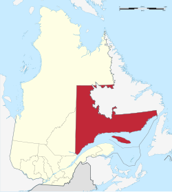 Map of Côte-Nord in relation to Quebec. | |
| Coordinates: 50°52′N 65°49′W | |
| Country | |
| Province | |
| Government | |
| • Regional conference of elected officers | Micheline Anctil (President) |
| Area | |
| • Total | 300,281.83 km2 (115,939.46 sq mi) |
| • Land | 247,655.33 km2 (95,620.26 sq mi) |
| Total area includes disputed land within Labrador | |
| Population (2016)[1] | |
| • Total | 92,518 |
| • Density | 0.4/km2 (1/sq mi) |
| Time zones | |
| Minganie and West of 63rd meridian west | UTC-05:00 (EST) |
| • Summer (DST) | UTC-04:00 (EDT) |
| East of 63rd meridian west, except Minganie | UTC-04:00 (AST) |
| Website | www.cotenord.gouv.qc.ca |
While most of the region is in the same time zone as the rest of Quebec, the far eastern portion east of the 63rd meridian, excluding the Minganie Regional County Municipality, is officially in the Atlantic Time Zone and does not observe daylight saving time.[2]
Population

At the 2016 Canadian Census, the population amounted to 92,518, approximately 1.1% of the province's population,[1] spread across 33 municipalities, various Indian reserves and a Naskapi reserved land. The towns of Baie-Comeau and Sept-Îles combined amount to a little more than half of the population of the region.
Geography and economy
Côte-Nord was created as an administrative region in 1966. Important landmarks of Côte-Nord include Anticosti Island, the Mingan Archipelago, and the Manicouagan Reservoir.
A territorial dispute between Quebec and Newfoundland and Labrador concerning the border between Côte-Nord and Labrador was set on 2 March 1927 by the Judicial Committee of the Privy Council. The boundary was entrenched in the Canadian constitution upon Newfoundland joining confederation in 1949. While this border has not been formally accepted by the Quebec government, the Henri Dorion Commission (Commission d'étude sur l'intégrité du territoire du Québec) concluded in the early 1970s that Quebec no longer has a legal claim to Labrador.[3]
The region's economy is based on mining (mostly iron), lumbering, aluminum production, and tourism. Côte-Nord's fourteen hydroelectric dams, notably the Manicouagan-Outardes complex, supply Hydro-Québec with over 10,500 megawatts of power.
Administrative divisions
Regional county municipalities
- Caniapiscau Regional County Municipality
- La Haute-Côte-Nord Regional County Municipality
- Le Golfe-du-Saint-Laurent Regional County Municipality
- Manicouagan Regional County Municipality
- Minganie Regional County Municipality
- Sept-Rivières Regional County Municipality
Indian reserves
- Essipit
- La Romaine
- Lac-John
- Maliotenam (part of Uashat-Maliotenam)
- Matimekosh
- Mingan
- Nutashkuan
- Pessamit
- Uashat (part of Uashat-Maliotenam)
Naskapi reserved territory
- Kawawachikamach
Major communities
- Baie-Comeau
- Fermont
- Forestville
- Havre-Saint-Pierre
- Pessamit
- Port-Cartier
- Sept-Îles
Exploration
The Côte-Nord region was gradually explored by French colonists during the centuries with the help of natives. However it is worth noting the contribution of Henry de Puyjalon (1841-1905), a pioneer in ecology who devoted his life to the exploration of this region.
See also
- Mingan Archipelago
- Quebec Route 138
References
- "Census Profile, 2016 Census: Côte-Nord [Economic region], Quebec". Statistics Canada. Retrieved November 23, 2019.
- "Legal Time Act, CQLR c T-5.1". CanLII. Retrieved September 21, 2021.
- "Henri Dorion debunks the Ten Great Myths about the Labrador boundary". Quebec National Assembly, First Session, 34th Legislature. October 17, 1991. Archived from the original on October 26, 2009. Retrieved May 18, 2011.
External links
| Regional county municipalities and equivalent territories | |
|---|---|
| Municipalities |
|
Administrative divisions of Quebec | |
Authority control | |
|---|---|
| General | |
| National libraries | |
На других языках
- [en] Côte-Nord
[ru] Кот-Нор
Кот-Нор (фр. La Côte-Nord, «Северный Берег») — обширный административный регион на северо-востоке провинции Квебек, граничит с провинцией Ньюфаундленд-и-Лабрадор на востоке, Сагеней[уточнить] на западе и Северный Квебек на севере. Его преимущественно франко-канадское население проживает на северном берегу р. Св. Лаврентия, постепенно переходящей в одноимённый залив. Экономика региона представлена рыболовством, лесозаготовкой и лесопереработкой, добычей железных и титановых руд, а также гидроэнергетикой. Административно Кот-Нор разделен на 6 региональных и 33 местных муниципалитета. Его административный центр — г. Сет-Иль. В 500 км к северу расположен полузаброшенный шахтёрский посёлок Шеффервилл. Имеются индейские резервации (Наташкуан и др.) Кот-Нор относится к регионам Крайнего СевераДругой контент может иметь иную лицензию. Перед использованием материалов сайта WikiSort.org внимательно изучите правила лицензирования конкретных элементов наполнения сайта.
WikiSort.org - проект по пересортировке и дополнению контента Википедии