world.wikisort.org - Benin
Karimama is a town, arrondissement and commune in the Alibori Department of northeastern Benin. The commune covers an area of 6102 square kilometers and as of 2013 had a population of 66,675 people.[1][2] The town lies on the border with Niger.
Karimama | |
|---|---|
Commune, arrondissement and city | |
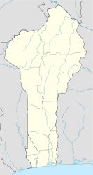 Karimama Location in Benin | |
| Coordinates: 12°04′N 3°11′E | |
| Country | |
| Department | Alibori Department |
| Area | |
| • Total | 6,102 km2 (2,356 sq mi) |
| Elevation | 164 m (538 ft) |
| Population (2013 census) | |
| • Total | 66,675 |
| • Density | 11/km2 (28/sq mi) |
| Time zone | UTC+1 (WAT) |
| Area code(s) | (+229) 95 |
Geography
The commune of Karimana is located 778 kilometres from Cotonou and lies on the Niger River. Communally it is bounded to the north and east by Niger, south by Malanville and to the west by Banikoara.
Administrative divisions
Karimana is subdivided into 5 arrondissements; Karimama, Birni-Lafia, Bogo-Bogo, Kompa and Monsey. They contain 16 villages and 2 urban districts.[1]
Economy
Most of the population are engaged in agricultural activities followed by trade, transportation and handicrafts. The main crops grown are maize, cotton, sorghum, cowpeas, peanut, okra, cassava, onion, potatoes and rice.[1]
Climate
Karimama has a semi-arid climate (BSh) with hot dry season and humid, slightly cooler wet season.
| Climate data for Karimama | |||||||||||||
|---|---|---|---|---|---|---|---|---|---|---|---|---|---|
| Month | Jan | Feb | Mar | Apr | May | Jun | Jul | Aug | Sep | Oct | Nov | Dec | Year |
| Average high °C (°F) | 33.6 (92.5) |
36.6 (97.9) |
39.5 (103.1) |
40.4 (104.7) |
38.1 (100.6) |
35.5 (95.9) |
32.5 (90.5) |
31.4 (88.5) |
32.7 (90.9) |
36.1 (97.0) |
36.5 (97.7) |
33.9 (93.0) |
35.6 (96.0) |
| Daily mean °C (°F) | 25.8 (78.4) |
29 (84) |
32.1 (89.8) |
33.6 (92.5) |
32.5 (90.5) |
30.1 (86.2) |
27.8 (82.0) |
27 (81) |
27.6 (81.7) |
29.3 (84.7) |
28.1 (82.6) |
26 (79) |
29.1 (84.4) |
| Average low °C (°F) | 18 (64) |
21.5 (70.7) |
24.8 (76.6) |
26.9 (80.4) |
27 (81) |
24.7 (76.5) |
23.2 (73.8) |
22.7 (72.9) |
22.6 (72.7) |
22.6 (72.7) |
19.8 (67.6) |
18.1 (64.6) |
22.7 (72.8) |
| Average precipitation mm (inches) | 0 (0) |
0 (0) |
2 (0.1) |
17 (0.7) |
49 (1.9) |
111 (4.4) |
165 (6.5) |
191 (7.5) |
130 (5.1) |
19 (0.7) |
0 (0) |
0 (0) |
684 (26.9) |
| Source: Climate-Data.org[3] | |||||||||||||
References
- "Karimama". Atlas Monographique des Communes du Benin. Archived from the original on February 26, 2009. Retrieved January 5, 2010.
- "Communes of Benin". Statoids. Archived from the original on April 30, 2012. Retrieved January 5, 2010.
- "Climate: Karimama". Climate-Data.org. Retrieved August 17, 2019.
| Alibori Department |  | |
|---|---|---|
| Atakora Department | ||
| Atlantique Department | ||
| Borgou Department | ||
| Collines Department |
| |
| Donga Department | ||
| Kouffo Department | ||
| Littoral Department | ||
| Mono Department | ||
| Ouémé Department |
| |
| Plateau Department | ||
| Zou Department |
| |
| Banikoara | 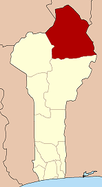 | |
|---|---|---|
| Gogounou | ||
| Kandi | ||
| Karimama | ||
| Malanville |
| |
| Ségbana | ||
This Alibori Department location article is a stub. You can help Wikipedia by expanding it. |
На других языках
- [en] Karimama, Benin
[ru] Каримама
Каримама (фр. Karimama) — коммуна Бенина. Площадь 6 102 км², население 66 353 человек (2013)[2].Другой контент может иметь иную лицензию. Перед использованием материалов сайта WikiSort.org внимательно изучите правила лицензирования конкретных элементов наполнения сайта.
WikiSort.org - проект по пересортировке и дополнению контента Википедии