world.wikisort.org - Belgium
Fleurus (French pronunciation: [flœ.ʁys] (![]() listen); Walloon: Fleuru) is a city and municipality of Wallonia located in the province of Hainaut, Belgium. It has been the site of four major battles.
listen); Walloon: Fleuru) is a city and municipality of Wallonia located in the province of Hainaut, Belgium. It has been the site of four major battles.
Fleurus
| |
|---|---|
Municipality | |
 | |
 Coat of arms | |
Location of Fleurus  | |
 Fleurus Location in Belgium
Location of Fleurus in Hainaut 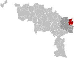 | |
| Coordinates: 50°29′N 04°32′E | |
| Country | Belgium |
| Community | French Community |
| Region | Wallonia |
| Province | Hainaut |
| Arrondissement | Charleroi |
| Government | |
| • Mayor | Loïc D'Haeyer (PS) |
| • Governing party/ies | PS - DéFI |
| Area | |
| • Total | 59.28 km2 (22.89 sq mi) |
| Population (2018-01-01)[1] | |
| • Total | 22,738 |
| • Density | 380/km2 (990/sq mi) |
| Postal codes | 6220-6224 |
| Area codes | 071 |
| Website | www.fleurus.be |
The municipality consists of the following districts: Brye, Heppignies, Fleurus, Lambusart, Saint-Amand, Wagnelée, Wanfercée-Baulet (wa: Wanfercêye-Bålet), and Wangenies.
History
Traces of agriculture dating back to the Neolithic Age were found in area known as Fleurjoux and Neuve Baraque. Later the site saw the construction of the Chaussée Brunehaut, a road network of uncertain origin, perhaps attributable to the Roman Empire.
In October 1155, Henry IV of Luxembourg, also Count of Namur enfranchised the municipality which became the city of Fleurus. Henry IV had a castle in Heppignies.
The town has given its name to three battles fought in the area :
- The Battle of Fleurus (1622) in the Thirty Years' War.
- The Battle of Fleurus (1690) in the Nine Years' War.
- The Battle of Fleurus (1794) in the French Revolutionary Wars.
Two days before the Battle of Waterloo in 1815 Napoleon I defeated the Prussians in what is known as the Battle of Ligny, although the pivotal action took place just north of Fleurus.
The battles have been commemorated in ship names of the countries involved, which in turn has led to Fleurus Island in Antarctica being named after SS Fleurus,[2] a Norwegian trawler operated between the Falkland Islands and the whaling station on South Georgia in the 1920s. The "Rue de Fleurus" is on the Left Bank in Paris.
In World War II, the only fighting near Fleurus was a tank battle southwest of the town at Vieux Campinaire in September 1944.
0.1 km2 (24.71 acres) was added to the municipality's area in the early 2000s.
Economy
Children's publisher Proost is a major local employer. The Institut national des radioéléments produces radioactive isotopes for medical use.
Historical population
| Year | Population | Density | Area |
|---|---|---|---|
| January 2002 | 22,324 (10,626 males and 11,698 females) | 377.22/km² | 59.18 km² |
| January 2004 | 22,209 (10,619 males, 11,590 females) | 374.64/km² | 59.28 km² |
References
- "Wettelijke Bevolking per gemeente op 1 januari 2018". Statbel. Retrieved 9 March 2019.
- "Fleurus Island". Geographic Names Information System. United States Geological Survey, United States Department of the Interior. Retrieved 3 December 2013.
External links
 Media related to Fleurus at Wikimedia Commons
Places adjacent to Fleurus | ||||||||||||||||
|---|---|---|---|---|---|---|---|---|---|---|---|---|---|---|---|---|
| ||||||||||||||||
Municipalities in the province of Hainaut, Wallonia, Belgium | ||
|---|---|---|
| Ath |  | |
| Charleroi | ||
| La Louvière | ||
| Mons | ||
| Soignies | ||
| Thuin | ||
| Tournai-Mouscron | ||
Bold indicates cities · Italic indicates municipalities with language facilities | ||
Authority control | |
|---|---|
| General | |
| National libraries | |
| Other |
|
На других языках
[de] Fleurus
Fleurus [.mw-parser-output .IPA a{text-decoration:none}flœˈʀʏs], wallonisch Fleuru, ist eine Gemeinde in der belgischen Provinz Hennegau, Arrondissement Charleroi. Die Stadt liegt an der Sambre und ist ein Knotenpunkt an der Eisenbahnlinie Tamines–Landen.- [en] Fleurus
[ru] Флёрюс
Флёрюс (фр. Fleurus) — муниципалитет в бельгийской провинции Эно. На 1 января 2013 года численность населения составляла 22 742 человека. Общая площадь составляет 59,28 км², плотность населения 375 чел./км² (47,88 % мужчин и 52,12 % женщин). Почтовый индекс для большинства мест — 6220.Другой контент может иметь иную лицензию. Перед использованием материалов сайта WikiSort.org внимательно изучите правила лицензирования конкретных элементов наполнения сайта.
WikiSort.org - проект по пересортировке и дополнению контента Википедии