world.wikisort.org - Belgium
Antoing (French pronunciation: [ɑ̃twɛ̃] (![]() listen); Picard: Antweon) is a city and municipality of Wallonia located in the province of Hainaut, Belgium.
listen); Picard: Antweon) is a city and municipality of Wallonia located in the province of Hainaut, Belgium.
This article needs additional citations for verification. (October 2021) |
Antoing
| |
|---|---|
Municipality | |
 | |
 Flag  Coat of arms | |
Location of Antoing  | |
 Antoing Location in Belgium
 | |
| Coordinates: 50°34′N 03°27′E | |
| Country | Belgium |
| Community | French Community |
| Region | Wallonia |
| Province | Hainaut |
| Arrondissement | Tournai |
| Government | |
| • Mayor | Bernard Bauwens |
| Area | |
| • Total | 31.13 km2 (12.02 sq mi) |
| Population (2018-01-01)[1] | |
| • Total | 7,760 |
| • Density | 250/km2 (650/sq mi) |
| Postal codes | 7640-7643 |
| Area codes | 069 |
The municipality consists of the following districts: Antoing, Bruyelle, Calonne, Fontenoy, Maubray, and Péronnes-lez-Antoing.
History
The Battle of Fontenoy, a major battle in the War of Austrian Succession, was fought near Fontenoy on 11 May 1745.
Places of interest
- Antoing Castle, originally from the 12th century, restored by Eugène Viollet-le-Duc in the 19th century[2]
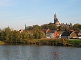 Antoing Castle, castle of the Princes de Ligne (13th - 16th centuries)
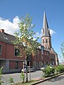 Churchtower (l'église Saint-Pierre)


Famous inhabitants
- Raoul Cauvin, comics writer, was born in Antoing in 1938
References
- "Wettelijke Bevolking per gemeente op 1 januari 2018". Statbel. Retrieved 9 March 2019.
- Ghidrai, George. "Antoing Castle". www.castlesworld.com. Retrieved 2021-08-22.
External links
 Media related to Antoing at Wikimedia Commons
Places adjacent to Antoing | ||||||||||||||||
|---|---|---|---|---|---|---|---|---|---|---|---|---|---|---|---|---|
| ||||||||||||||||
Municipalities in the province of Hainaut, Wallonia, Belgium | ||
|---|---|---|
| Ath |  | |
| Charleroi | ||
| La Louvière | ||
| Mons | ||
| Soignies | ||
| Thuin | ||
| Tournai-Mouscron | ||
Bold indicates cities · Italic indicates municipalities with language facilities | ||
This Hainaut Province location article is a stub. You can help Wikipedia by expanding it. |
На других языках
[de] Antoing
Antoing ist eine Gemeinde in der belgischen Provinz Hennegau in Wallonien an der Grenze zu Frankreich.- [en] Antoing
[ru] Антуэн (Бельгия)
Антуэ́н[1] (фр. Antoing, французское произношение: [ɑ̃twɛ̃]; пикард. Antweon) — коммуна в Валлонии, расположена в провинции Эно в округе Турне. Принадлежит Французскому языковому сообществу Бельгии. Площадь коммуны — 31,13 км². Население на 1 июля 2016 года — 7846 человек[2], из которых 3790 — мужчины и 4056 — женщины. Плотность населения — 252,01 чел./км² (01.07.2016). Доля иммигрантов — 4,84 % (01.01.2013), безработных — 15,30 % (октябрь 2013 года). Средний годовой доход на душу населения в 2011 году составлял 11 934 евро.Текст в блоке "Читать" взят с сайта "Википедия" и доступен по лицензии Creative Commons Attribution-ShareAlike; в отдельных случаях могут действовать дополнительные условия.
Другой контент может иметь иную лицензию. Перед использованием материалов сайта WikiSort.org внимательно изучите правила лицензирования конкретных элементов наполнения сайта.
Другой контент может иметь иную лицензию. Перед использованием материалов сайта WikiSort.org внимательно изучите правила лицензирования конкретных элементов наполнения сайта.
2019-2026
WikiSort.org - проект по пересортировке и дополнению контента Википедии
WikiSort.org - проект по пересортировке и дополнению контента Википедии