world.wikisort.org - Belgium
Anderlecht (French: [ɑ̃dəʁlɛkt], Dutch: [ˈɑndərlɛxt] (![]() listen)) is one of the 19 municipalities of the Brussels-Capital Region, Belgium. Located in the south-western part of the region, it is bordered by the City of Brussels, Forest, Molenbeek-Saint-Jean, and Saint-Gilles, as well as the Flemish municipalities of Dilbeek and Sint-Pieters-Leeuw. In common with all of Brussels' municipalities, it is legally bilingual (French–Dutch).
listen)) is one of the 19 municipalities of the Brussels-Capital Region, Belgium. Located in the south-western part of the region, it is bordered by the City of Brussels, Forest, Molenbeek-Saint-Jean, and Saint-Gilles, as well as the Flemish municipalities of Dilbeek and Sint-Pieters-Leeuw. In common with all of Brussels' municipalities, it is legally bilingual (French–Dutch).
This article may be expanded with text translated from the corresponding article in French. (August 2016) Click [show] for important translation instructions.
|
Anderlecht | |
|---|---|
Municipality | |
 Anderlecht's Municipal Hall seen from the Place du Conseil/Raadsplein | |
 Flag  Coat of arms | |
Location of Anderlecht  | |
 Anderlecht Location in Belgium
Anderlecht municipality in the Brussels-Capital Region  | |
| Coordinates: 50°50′N 04°20′E | |
| Country | |
| Community | Flemish Community French Community |
| Region | Brussels-Capital |
| Arrondissement | Brussels-Capital |
| Government | |
| • Mayor | Fabrice Cumps (PS) |
| • Governing party/ies | PS - sp.a - cdH - Ecolo - Groen - DéFI |
| Area | |
| • Total | 17.91 km2 (6.92 sq mi) |
| Population (2020-01-01)[1] | |
| • Total | 120,887 |
| • Density | 6,700/km2 (17,000/sq mi) |
| Postal codes | 1070 |
| Area codes | 02 |
| Website | www.anderlecht.be/fr (in French) www.anderlecht.be/nl (in Dutch) |
There are several historically and architecturally distinct districts within Anderlecht. As of 1 January 2020[update], the municipality had a population of around 120,887.[2] The total area is 17.74 km2 (6.85 sq mi), which gives a population density of 6,749/km2 (17,480/sq mi).[2] Its upper area is greener and less densely populated.
History
Origins and medieval times
The first traces of human activity on the right bank of the Senne date from the Stone Age and Bronze Age. The remnants of a Roman villa and of a Frankish necropolis were also found on the territory of Anderlecht. The first mention of the name Anderlecht, however, dates only from 1047 under the forms Anrelech, then Andrelet (1111), Andreler (1148), and Anderlech (1186). At that time, this community was already home to a chapter of canons and to two feudal manors, those of the powerful lords of Aa and of Anderlecht.

In 1356, the Count of Flanders, Louis II, fought against Brussels on the territory of Anderlecht, in the so-called Battle of Scheut, supposedly over a monetary matter. Although he defeated his sister-in-law, the Duchess of Brabant, Joanna, and briefly took her title, she regained it the following year with the help of the Holy Roman Emperor, Charles IV. In 1393, Joanna's charter made Anderlecht a part of Brussels. It is also around this time that the church of Saint Guy was rebuilt above an earlier Romanesque crypt in the Brabantian Gothic style.
15th–18th centuries
The village of Anderlecht became a beacon of culture in the 15th and 16th centuries. In 1521, the Dutch humanist writer Erasmus of Rotterdam lived in the canons' house for a few months. Charles, Duke of Aumale and Grand Veneur of France also had a residence there.
The 17th and 18th centuries were marked by the wars between the Low Countries and France. During the Nine Years' War, it is from the high ground of Scheut, in the northern part of Anderlecht, that the bombardment of Brussels of 1695 took place. Together with the resulting fire, it was the most destructive event in the entire history of Brussels. On 13 November 1792, right after the Battle of Jemappes, General Dumouriez and the French Revolutionary army routed the Austrians there once again. Among the consequences were the disbanding of the canons and Anderlecht being proclaimed an independent municipality by the French.

By the end of the 18th century, Anderlecht including its dependencies, which extended to Brussels' city walls, counted around 2,000 inhabitants. In Scheut, on the site of the Carthusian Monastery, stood a chapel called Our Lady of Scheut, whose pleasant location, in the middle of a grove, made this place very popular at the time.
19th century and later
The 19th century saw a remarkable population growth, mainly because of the proximity to a rapidly expanding Brussels. The Chaussée de Ninove/Ninoofsesteenweg was laid out in 1828, through the former property of the Carthusians. The population multiplied by ten between 1830 and 1890 and doubled again between 1890 and 1910. Along the Chaussée de Mons/Bergensesteenweg and the Brussels–Charleroi Canal, a series of industrial and working-class districts connected the centre of Anderlecht to Cureghem.
Remarkable new urban developments and garden cities such as La Roue/Het Rad, Moortebeek and Bon Air/Goede Lucht were built at the beginning of the 20th century to house the influx of newcomers. Following World War II, some remaining green parts of the municipality also made way for large-scale urban renewal following the modernist Athens Charter and Park system, such as the housing projects Scherdemael, Peterbos and Marius Renard in the upper town, and Aurore near the canal.
Nowadays, the name Anderlecht rings a bell in every Belgian ear thanks to its very successful football club.
Geography
Location

Anderlecht is located in the north-central part of Belgium, about 110 kilometres (68 mi) from the Belgian coast and about 180 km (110 mi) from Belgium's southern tip. It is located in the heartland of the Brabantian Plateau, about 45 km (28 mi) south of Antwerp (Flanders), and 50 km (31 mi) north of Charleroi (Wallonia). It is the westernmost municipality in the Brussels-Capital Region and is an important crossing point for the Brussels–Charleroi Canal, which cuts the municipality in two from the west. With an area of 17.74 km2 (6.85 sq mi), it is also the third largest municipality in the region after the City of Brussels and Uccle. It is bordered by the City of Brussels, Forest, Molenbeek-Saint-Jean, and Saint-Gilles, as well as the Flemish municipalities of Dilbeek and Sint-Pieters-Leeuw.
Climate
Anderlecht, in common with the rest of Brussels, experiences an oceanic climate (Köppen: Cfb) with warm summers and cool winters.[3] Proximity to coastal areas influences the area's climate by sending marine air masses from the Atlantic Ocean. Nearby wetlands also ensure a maritime temperate climate. On average (based on measurements in the period 1981–2010), there are approximately 135 days of rain per year in the region. Snowfall is infrequent, averaging 24 days per year. It also often experiences violent thunderstorms in summer months.
The Royal Meteorological Institute of Belgium (IRM/KMI) is located in Uccle, in the south of Brussels. The meteorological records which are carried out there are similar to those which could be carried out in Anderlecht.
| Climate data for Brussels-Capital Region (1981–2010) | |||||||||||||
|---|---|---|---|---|---|---|---|---|---|---|---|---|---|
| Month | Jan | Feb | Mar | Apr | May | Jun | Jul | Aug | Sep | Oct | Nov | Dec | Year |
| Average high °C (°F) | 5.9 (42.6) |
6.8 (44.2) |
10.5 (50.9) |
14.2 (57.6) |
18.3 (64.9) |
20.9 (69.6) |
23.3 (73.9) |
23.0 (73.4) |
19.5 (67.1) |
15.1 (59.2) |
9.8 (49.6) |
6.3 (43.3) |
14.5 (58.1) |
| Daily mean °C (°F) | 3.2 (37.8) |
3.5 (38.3) |
6.5 (43.7) |
9.5 (49.1) |
13.5 (56.3) |
16.1 (61.0) |
18.4 (65.1) |
18.0 (64.4) |
14.9 (58.8) |
11.1 (52.0) |
6.8 (44.2) |
3.8 (38.8) |
10.4 (50.7) |
| Average low °C (°F) | 0.7 (33.3) |
0.6 (33.1) |
2.9 (37.2) |
4.9 (40.8) |
8.7 (47.7) |
11.5 (52.7) |
13.6 (56.5) |
13.0 (55.4) |
10.5 (50.9) |
7.5 (45.5) |
4.5 (40.1) |
1.5 (34.7) |
6.7 (44.1) |
| Average precipitation mm (inches) | 75.2 (2.96) |
61.6 (2.43) |
69.5 (2.74) |
51.0 (2.01) |
65.1 (2.56) |
72.1 (2.84) |
73.6 (2.90) |
76.8 (3.02) |
69.6 (2.74) |
75.0 (2.95) |
77.0 (3.03) |
81.4 (3.20) |
848.0 (33.39) |
| Average precipitation days (≥ 1 mm) | 12.8 | 11.1 | 12.7 | 9.9 | 11.3 | 10.5 | 10.1 | 10.1 | 10.4 | 11.2 | 12.6 | 13.0 | 135.6 |
| Mean monthly sunshine hours | 58 | 75 | 119 | 168 | 199 | 193 | 205 | 194 | 143 | 117 | 65 | 47 | 1,583 |
| Source: KMI/IRM[4] | |||||||||||||
Districts

The territory of Anderlecht is very heterogeneous and is characterised by a mixture of larger districts including smaller residential and (formerly) industrial neighbourhoods. The area along the canal is currently experiencing a large revitalisation programme, as part of the Plan Canal of the Brussels-Capital Region.[5]
Historical centre

The historical centre of Anderlecht is the municipality's central district. Formerly known as Rinck, it is divided into several sectors:
- The Saint-Guidon/Sint Guido district, also called the Vaillance/Dapperheid district, is the meeting point for those who hail to the heart of Anderlecht. It is also where the Place de la Vaillance/Dapperheidsplein (Anderlecht's central square), the Church of St. Guido, the Place de Linde/De Lindeplein, as well as Anderlecht's main schools are located. The Rue Wayez/Wayezstraat is the municipality's main shopping street. It is centred on the Place of the Resistance/Verzetsplein and some neighbouring streets.
- The smaller Aumale district in its northern part mainly comprises the Rue d'Aumale/Aumalestraat and its surrounding streets. It includes the Erasmus House (a museum devoted to the Dutch humanist writer Erasmus of Rotterdam), the old beguinage (a type of lay convent common in the Late Middle Ages in the Low Countries and the Rhineland), as well as the Bibliothèque de l'Espace Maurice Carême French-language public library.
Cureghem/Kuregem
Located in the east of Anderlecht, Cureghem/Kuregem is one of the municipality's largest and most populated districts. It developed during the Industrial Revolution along the Brussels–Charleroi Canal and is currently in a fragile social and economic situation due to the decline of its economy and the poor quality of some of its housing. Between 1836 and 1991, the district housed the Royal School of Veterinary Medicine, now moved to Liège but often still referred to as Cureghem. The old campus, listed as protected heritage, is currently undergoing a large rehabilitation process.
Three listed buildings; the former Atlas Brewery, the old power station, and the former Moulart Mill, are testaments to the old industrial activities next to the waterway. The Municipal Hall of Anderlecht is located on the Place du Conseil/Raadsplein, at the heart of this district. In its lower part, bordering the City of Brussels, are the Square de l'Aviation/Luchtvaartsquare and the Parc de la Rosée/Dauwpark.
La Roue/Het Rad

Located in the south of Anderlecht, La Roue/Het Rad ("The Wheel") is one of the municipality's largest districts and one of Brussels' main garden cities. Built in the 1920s, with its modest and picturesque houses, it offers a great vision of an early 20th century working class neighbourhood. It is also home to one of the largest agribusiness industry campuses in Belgium; the Food and Chemical Industries Education and Research Center (CERIA/COOVI), as well as popular department stores.
Scheut
Located in the north of Anderlecht, Scheut is bounded by the border with the municipality of Molenbeek-Saint-Jean to the north, the historical centre of Anderlecht to the south, the Birmingham district to the east, the Scheutveld district to the west and the semi-natural site of the Scheutbos to the north-west.
It is in this district, on the Chaussée de Ninove/Ninoofsesteenweg, that lay the foundations of the Scheutveld College, on 28 April 1863, by the Catholic priest Theophile Verbist. The congregation of Scheut Missionaries went on to evangelise China, Mongolia, the Philippines, as well as the Congo Free State/Belgian Congo (modern-day Democratic Republic of the Congo).[6][7]
Main sights
Anderlecht has a rich cultural and architectural heritage.[8] Some of the main points of interest include:
- The Collegiate Church of St. Peter and St. Guido is located in the municipality's historical centre, on the northern side of the Place de la Vaillance/Dapperheidsplein, its main square. It contains the grave of the 11th century saint Guy of Anderlecht. Its Romanesque crypt dates from the 10th century and is one of the oldest in Belgium. Most of the church, however, dates from 1350 and later, with most of the currently visible architecture representing the Ogee style (15th–16th centuries). Construction of the tower started in 1517 but stopped with the square part up to the balcony, and was not completed until 1898.[9]
- The Erasmus House, built between 1460 and 1515, with its medicinal and philosophical gardens, can be visited nearby. Right next to the church, the old beguinage is home to a local historical museum. Both institutions are now managed jointly as the Erasmus House and Beguinage Museums.[10]
- The National Museum of the Resistance, which traces the history of the Belgian resistance and German occupation of Belgium during World War II.
- The Museum of China – Scheut, which houses documents and pieces brought back to Europe by the congregation of Scheut Missionaries, including a 15th-century bronze Buddha.[11]
- The Maurice Carême Museum, in the Maison blanche where the Belgian poet lived and wrote.[12]
- The Luizenmolen in Neerpede, a replica of an old windmill which once stood on the site.[13]
- The Cureghem Cellars (French: Caves de Cureghem, Dutch: Kelders van Kuregem), a subterranean complex of handmade brick caves with Romanesque vaults, pillars, and arches, originally the site of a cattle market covered by a forged-iron roof construction in the 1890s.[14] The cellars were simply a foundation for the upper structure until the 1930s, after which the city council decided to make better use of them. It proved more profitable to grow mushrooms in the dark and damp underground spaces for local consumption. It fell into disuse as a cattle market but, in 1984, the hall officially got listed as a Belgian monument. Due to its characteristic architecture and unique layout it was refurbished and transformed by a private company, Abattoir SA. Since 1992, it serves as an attractive and functional event site for various private, corporate or public occasions and events. One of these was the anatomic exposition Body Worlds (German: Körperwelten) by Dr. Gunther Von Hagens, which ran in the cellars between 2008 and 2009 and attracted over 500,000 visitors.
- The Cantillon Brewery, a gueuze museum established in an actual working brewery.
- The Museum of Medicine, located on the Erasme/Erasmus campus of the Université libre de Bruxelles (ULB).[15]
- The Jean-Claude Van Damme statue located on the Boulevard Sylvain Dupuis/Sylvain Dupuislaan, near the Westland Shopping Center.
 Erasmus House
 Beguinage of Anderlecht
 Moortebeek garden city
 Rue Porselein / Porseleinstraat
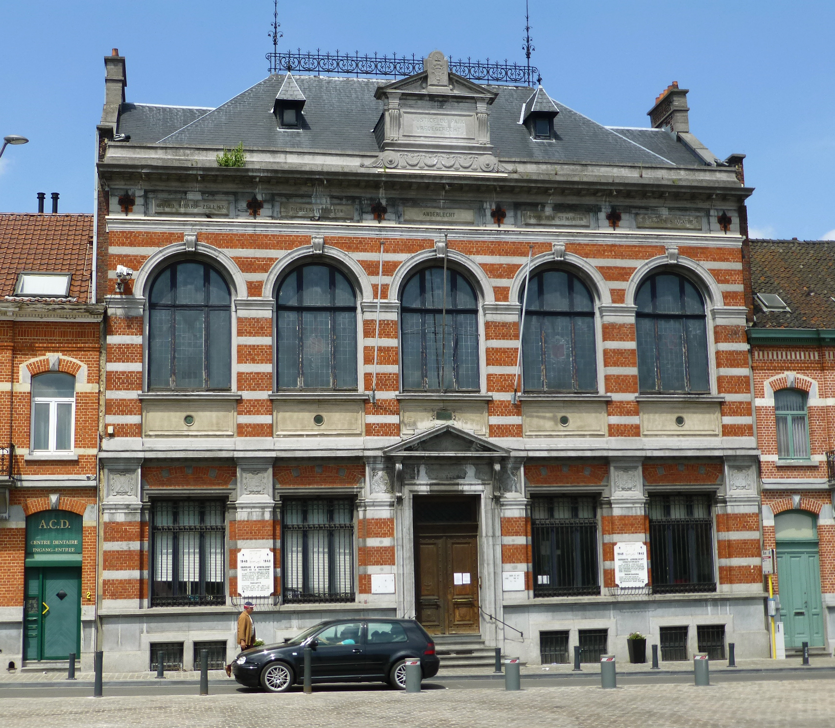
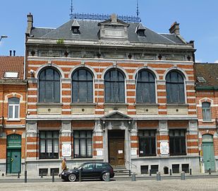 Justice de Paix of Anderlecht


Demographics
Historical population
Historically, the population of Anderlecht was quite low. The municipality counted around 2,000 inhabitants at the beginning of the 19th century. However, following the Industrial Revolution, the population underwent a remarkable growth, peaking at 103,796 in 1970. From then, it began to decrease slightly to a low of 87,812 in 2000, before increasing again rapidly in recent years.
As of 1 January 2020[update], the population was 120,887.[2] The area is 17.74 km2 (6.85 sq mi), making the density 6,749/km2 (17,480/sq mi).[2]

- Sources: INS: 1806 to 1981= census; 1990 and later = population on 1 January
Foreign population
Migrant communities in Anderlecht with over 1,000 people as of 1 January 2020:[16]
| 7,405 | |
| 4,924 | |
| 2,985 | |
| 2,743 | |
| 2,727 | |
| 2,628 | |
| 2,549 | |
| 1,717 |
Politics
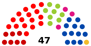
The current city council was elected in the October 2018 elections.[17] The current mayor of Anderlecht is Fabrice Cumps, a member of PS, who alongside the other parties on their list, sp.a and cdH, is in coalition on the municipal council with Ecolo - Groen, DéFI and Forward.[18]
 | ||||||||||
| Party | ||||||||||
|---|---|---|---|---|---|---|---|---|---|---|
| Votes | % | Swing (pp) | Elected 2018 |
Change | ||||||
| PS - sp.a - cdH | 14,023 | 29.73 | 16 / 47 (34%) |
|||||||
| MR - Open Vld - IC | 10,628 | 22.53 | 12 / 47 (26%) |
|||||||
| Ecolo - Groen | 7,320 | 15.52 | 8 / 47 (17%) |
|||||||
| PVDA-PTB | 6,891 | 14.61 | 7 / 47 (15%) |
|||||||
| DéFI | 3,581 | 7.59 | 3 / 47 (6%) |
|||||||
| N-VA | 1,950 | 4.13 | 1 / 47 (2%) |
|||||||
| VB | 1,006 | 2.13 | 0 / 47 (0%) |
|||||||
| CD&V Plus | 716 | 1.52 | New | 0 / 47 (0%) |
- | |||||
| Others | 1,059 | 2.25 | New | 0 / 47 (0%) |
- | |||||
Events
The annual Anderlecht fair, originally a cattle fair, was authorised by William II of the Netherlands in 1825. Since then, it has taken the form of a series of celebrations, which still include animal shows but also a large market, a floral show, and the recreation of a religious procession in honour of Saint Guy.
Economy
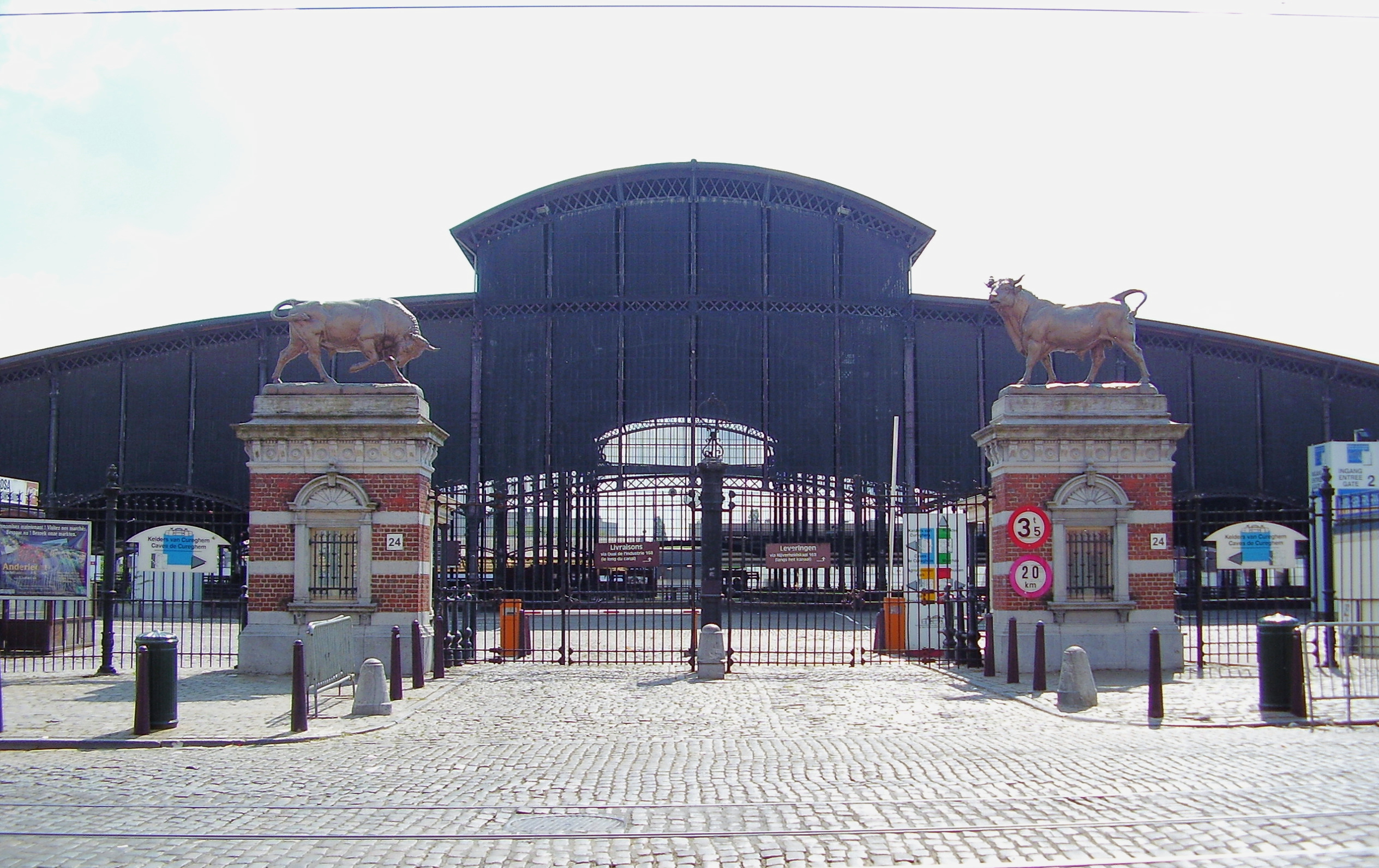
The Abattoirs of Anderlecht, located at 24, Rue Ropsy Chaudron/Ropsy Chaudronstraat in Cureghem, is the main slaughterhouse in Brussels, employing some 1,500 people. In addition to its main activities, the great hall serves as a covered market for food and flea markets.[19]
In recent years, several major international companies have set up their headquarters in Anderlecht, notably the Delhaize Group, which operates many supermarket chains, from 40, Marie Curie Square,[20] Coca-Cola Benelux at 1424, Chaussée de Mons/Bergensesteenweg,[21] as well as the Belgian chocolate company Leonidas at 41, Boulevard Jules Graindor/Jules Graindorlaan.[22]
Healthcare
Several hospitals and clinics are located in Anderlecht:
Sports
Football
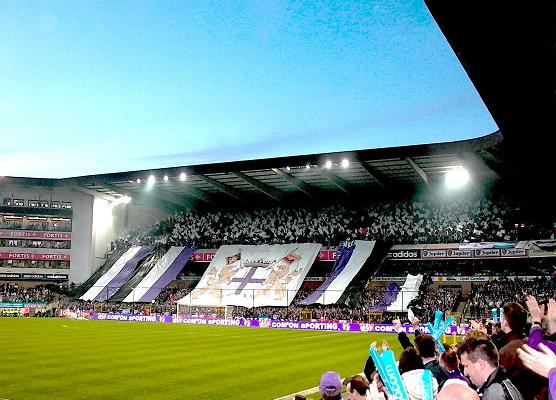
Anderlecht is the home of the football club RSC Anderlecht, the most successful Belgian football team in European competition as well as in the Belgian First Division with 34 titles.[25] The club's home stadium is the Constant Vanden Stock Stadium, located within Astrid Park. The team colours are white and purple.
Parks and green spaces
Green spaces in the municipality include:[26]
- Astrid Park
- Parc Forestier/Bospark, in Scheut
- Scherdemael Park
- Peterbos Park
- Joseph Lemaire Park
- Jean Vives Park
- Parc des Étangs/Vijverspark, in Neerpede
- Parc de la Rosée/Dauwpark, in Cureghem
- The Vogelzang or Vogelenzang, a natural protected area
Famous inhabitants

- Guy of Anderlecht (c. 950–1012), known as the Poor Man of Anderlecht, patron saint of Anderlecht[27]
- Adrian VI (1459–1523), pope, theologian, rector at the University of Leuven, canon at the Chapter of Anderlecht, lived there.
- Joseph Bracops (1900–1966), politician and mayor of Anderlecht
- Jacques Brel, singer-songwriter and actor. He lived from 1942 to 1951 at 7, Rue Jacques Manne/Jacques Mannestraat, and worked from 1946 to 1953 in the family cardboard box factory Vanneste & Brel (now SCA Packaging) at 18, Rue Verheyden/Verheydenstraat. A nearby metro station is named after him.
- Maurice Carême (1899–1978), poet
- Fernand Dineur (1904–1956), cartoonist
- Benoît Drousie, also known as Zidrou (b. 1962), comic book artist
- Desiderius Erasmus (1466–1536), humanist and theologian
- Jean Hayet (1939–2006), actor, stage manager and professor of the Théâtre royal des Galeries
- André Jacqmain (1921–2014), architect
- Désiré Keteleer (1920–1970), cyclist
- Filip Peeters (b. 1962), Flemish actor
- Germaine Schneider (1903–1945), Belgian-Swiss member of the Resistance during World War II
- Henri Seroka (b. 1949), singer and composer
- Henri Simonet (1931–1996), politician and mayor of Anderlecht
- Jacques Simonet (1963–2007), politician, mayor of Anderlecht, and Minister-President of the Brussels-Capital Region
- Marcel Spittael (1899–1981), architect
- Philippe Thys (1889–1971), cyclist and three-time champion of the Tour de France
- Tonia (Arlette Antoine Dominicus) (b. 1947), singer, represented Belgium at the 11th Eurovision Song Contest in 1966
- Toots Thielemans (1922–2016), jazz musician, lived there.
- William Vance (b. 1935), comic book artist
- Constant Vanden Stock (1914–2008), entrepreneur, footballer, functionary, and coach of the Belgian national team
- Virgile Vandeput (b. 1994), Belgian-born alpine skier who competes for Israel
- Régine Zylberberg, better known as Régine (b. 1929), chanson singer, actress and nightclub entrepreneur
Born in Anderlecht:
- Princess Elisabeth, Duchess of Brabant (b. 2001), Duchess of Brabant, the eldest child of King Philippe and Queen Mathilde; heiress
- Princes Gabriel and Emmanuel and Princess Eléonore; 2nd, 3rd and 4th in line to the throne of Belgium
- Yannick Mertens (b. 1987), professional tennis player
International relations
Twin towns and sister cities
Anderlecht is twinned with:[28]
 Boulogne-Billancourt, France
 Berlin-Neukölln, Germany
 London Borough of Hammersmith and Fulham, United Kingdom
 Zaandam, Netherlands
 Marino, Italy
In addition, Anderlecht has signed a friendship agreement with:[28]
- Sainte-Maxime, France
References
Notes
- "Bevolking per gemeente op 1 januari 2020". Statbel.
- "Anderlecht | IBSA". ibsa.brussels. Retrieved 6 October 2021.
- "Brussels, Belgium Köppen Climate Classification (Weatherbase)". Weatherbase. Retrieved 2 July 2019.
- "Klimaatstatistieken van de Belgische gemeenten, Brussel" (PDF). KMI/IRM. Archived from the original (PDF) on 2 March 2021. Retrieved 3 January 2021.
- "Plan canal: des ambitions, une méthode, une équipe | Canal.brussels". canal.brussels. Retrieved 28 April 2017.
- Verhelst & Pycke 1995.
- Vanysacker & Renson 1995, p. 36–37.
- "Anderlecht – Inventaire du patrimoine architectural". monument.heritage.brussels (in French). Retrieved 6 October 2021.
- Eug. De Seyn, "Geschied- en aardrijkskundig woordenboek der Belgische gemeenten" (Historic and Geographic Dictionary of Belgian communes), A. Bieleveld, Brussels 1933-1934.
- "Erasmus House". Erasmus House. Retrieved 24 December 2021.
- Fun, Everything is (10 March 2017). "Museum of China - Scheut". Brussels Museums. Retrieved 14 December 2019.
- "Musée Maurice Carême". www.mauricecareme.be. Retrieved 14 December 2019.
- "Luizenmolen Anderlecht". users.skynet.be. Retrieved 14 December 2019.
- "Kelders van Cureghem/Les Caves de Cureghem/The Cureghem Cellars". Retrieved 14 December 2019.
- Fun, Everything is (10 March 2017). "ULB - Museum of Medicine". Brussels Museums. Retrieved 14 December 2019.
- "Nationalités". ibsa.
- "Résultats officiels des élections communales 2018" (in French). Retrieved 17 July 2021.
- "Anderlecht: l'acte de présentation d'Eric Tomas à la fonction de bourgmestre est signé" (in French). 15 October 2018. Retrieved 17 July 2021.
- "Slaughterhouse". Retrieved 14 December 2019.
- "Contacts Archived 2012-05-22 at the Wayback Machine." Delhaize Group. Retrieved on 16 May 2012. "Square Marie Curie 40 1070 Brussels - Belgium"
- "Contact" (in French). Retrieved 17 February 2017.
- "Leonidas - Bienvenue dans un monde chocolat". www.leonidas.com. Retrieved 17 February 2017.
- "Joseph Bracops". www.his-izz.be. Retrieved 14 December 2019.
- "St-Anne St-Remi Clinic - Our hospital sites - Chirec". chirec.be. Retrieved 14 December 2019.
- "Belgium - List of Champions". www.rsssf.com. Retrieved 17 February 2017.
- Decker, Frédéric De. "Parcs publics". www.anderlecht.be. Archived from the original on 30 December 2016. Retrieved 29 December 2016.
- Guy of Anderlecht at saints.sqpn.com. Retrieved 26.March 2013
- Decker, Frédéric De. "Projets européens". www.anderlecht.be (in French). Archived from the original on 1 March 2017. Retrieved 28 February 2017.
Bibliography
- Verhelst, Daniël; Pycke, Nestor (1995). C.I.C.M. Missionaries Past and Present: History of the Congregation of the Immaculate Heart of Mary (Scheut/Missionhurst). Verbistiana. Vol. 4. Leuven: Leuven University Press. ISBN 978-90-6186-676-3.
- Vanysacker, Dries; Renson, Raymond (1995). The Archives of the Congregation of the Immaculate Heart of Mary (CICM-Scheut) (1862–1967) - 2 v. Rome: Bibliothèque de l'Institut Historique Belge de Rome. ISBN 978-90-74461-15-3.
External links
 Media related to Anderlecht at Wikimedia Commons
- Official website (in French and Dutch)
Places adjacent to Anderlecht | ||||||||||||||||
|---|---|---|---|---|---|---|---|---|---|---|---|---|---|---|---|---|
| ||||||||||||||||
Brussels | ||||||||||||
|---|---|---|---|---|---|---|---|---|---|---|---|---|
| ||||||||||||
| ||||||||||||

Authority control | |
|---|---|
| General | |
| National libraries | |
| Other |
|
На других языках
[de] Anderlecht
Anderlecht (niederländisch .mw-parser-output .IPA a{text-decoration:none}ɑndərˌlɛxt; französisch ɑ̃dɛʁlɛkt) ist eine Gemeinde in der zweisprachigen Region Brüssel-Hauptstadt in Belgien. Sie ist nach der Stadt Brüssel und Schaerbeek/Schaarbeek die drittbevölkerungsreichste der 19 Gemeinden innerhalb der Region.- [en] Anderlecht
[it] Anderlecht
Anderlecht è un comune belga di 118.382 abitanti, situato nella Regione di Bruxelles-Capitale.[ru] Андерлехт
А́ндерлехт (нидерл. Anderlecht, фр. Anderlecht, Андерле́кт) — одна из девятнадцати коммун, образующих Брюссельский столичный регион. Находится в западной части Брюссельской агломерации, граничит с семью коммунами (по часовой стрелке): Моленбек-Сен-Жан, город Брюссель, Сен-Жиль, Форет, Дрогенбос, Синт-Питерс-Леув и Дилбек (первые четыре коммуны — брюссельские, остальные — фламандские).Другой контент может иметь иную лицензию. Перед использованием материалов сайта WikiSort.org внимательно изучите правила лицензирования конкретных элементов наполнения сайта.
WikiSort.org - проект по пересортировке и дополнению контента Википедии