world.wikisort.org - Belgium
Auderghem (former Dutch spelling, now used in French; pronounced [odəʁɡɛm]) or Oudergem (Dutch: [ˈʌudərɣɛm] (![]() listen)) is one of the 19 municipalities of the Brussels-Capital Region (Belgium).
listen)) is one of the 19 municipalities of the Brussels-Capital Region (Belgium).
Auderghem
| |
|---|---|
Municipality | |
 Château Sainte-Anne | |
 Flag  Coat of arms | |
Location of Auderghem  | |
 Auderghem Location in Belgium
Auderghem municipality in the Brussels-Capital Region  | |
| Coordinates: 50°49′00″N 04°25′34″E | |
| Country | Belgium |
| Community | Flemish Community French Community |
| Region | Brussels-Capital |
| Arrondissement | Brussels-Capital |
| Government | |
| • Mayor | Sophie de Vos |
| • Governing party/ies | LB (DéFI), Ecolo-Groen |
| Area | |
| • Total | 9.03 km2 (3.49 sq mi) |
| Population (2020-01-01)[1] | |
| • Total | 34,404 |
| • Density | 3,800/km2 (9,900/sq mi) |
| Postal codes | 1160 |
| Area codes | 02 |
| Website | www.auderghem.be (in French) www.oudergem.be (in Dutch) |
Located to the southeast of the region, along the Woluwe valley and at the entrance to the Sonian Forest (French: Forêt de Soignes, Dutch: Zoniënwoud), the municipality has an environmental advantage. Despite large roads slicing through and the increasing traffic, it has been able to preserve a relatively important part of its natural and historic legacy: the creeks, the Red Cloister Abbey and its art centre, the Priory of Val-Duchesse, the Château of Three Fountains (French: Trois Fontaines, Dutch: Drie Fonteinen), the Château of Saint Anne, and the remarkable Chapel of Saint Anne.
Auderghem is adjacent to the municipalities of Etterbeek, Ixelles, Woluwe-Saint-Pierre, and Watermael-Boitsfort. In common with all of Brussels’ municipalities, it is legally bilingual (French–Dutch).
The municipality is governed by its 16th mayor, Didier Gosuin (FDF).
History
Three forest villages (Auderghem, Watermael, and Boitsfort-Bosvoorde), were one for centuries. In 1794, the soldiers of the French Revolution decided to separate these into three distinct municipalities. In 1811, Napoleon decided to reunite the three villages, by imperial decree, into a single administrative entity. But Auderghem was withdrawn from this union by royal act, leaving Watermael-Boitsfort on its own. Thus, Auderghem became an independent municipality in 1863, with only 1,600 inhabitants.
With the construction of the rail line linking Brussels and Tervuren as well as, in 1910, the construction of Boulevard du Souverain/Vorstlaan, modernisation came to the municipality and the population grew quickly.
In 1956, Paul Henri Spaak lead the Intergovernmental Conference on the Common Market and Euratom at the Château of Val-Duchesse in Auderghem, which prepared the Treaties of Rome in 1957 and the foundation of the European Economic Community and Euratom in 1958.
Demographics
As of 2004 the majority of Brussels' Japanese expatriate population lives in Auderghem.[2]
Sights
The Priory of Val-Duchesse, a gift of the Belgian King, is rarely open to the public. In 1963, Belgium's cabinet ministers met there, planting the seeds of a federalisation of the country though at conditions fiercely criticised especially in some extremist Flemish nationalist circles.
Similarly, the Chapel of Saint Anne, whose origins go back to the 12th century, is not open to the public. Decommissioned in 1843, it was sold several times. Its splendid sculptures from the Middle Ages and notable period furniture are still there to admire.
The municipality offers many green spaces.
 Red Cloister Abbey
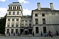 Château of Val-Duchesse
 Chapel of Saint Anne


Notable inhabitants
- Léon Huygens, painter (1876–1918)
- Odette De Wynter (1927 – 1998), the first women to be a notary in Belgium.
Education
Public secondary schools from the French Community of Belgium:[3]
- Athénée Royal d'Auderghem
Subsidised religious secondary schools:[3]
- Centre scolaire St-Adrien Val Duchesse
- Institut St-Julien Parnasse
- Ecole Sainte-Bernadette
- Institut Dominique Pire
Subsidised non-religious secondary schools:[3]
- De l'autre côté de l'école
Private international schools:[3]
- The Japanese School of Brussels[4]
See also
- Municipalities of the Brussels-Capital Region
References
- "Bevolking per gemeente op 1 januari 2020". Statbel.
- State, Paul F. Historical Dictionary of Brussels. Scarecrow Press, July 27, 2004. ISBN 0810865556, 9780810865556. p. 21.
- "Ecoles secondaires." Auderghem. Retrieved on September 12, 2016.
- "ブラッセル日本人学校 TOP:" The Japanese School of Brussels. Retrieved on 2 January 2014. "Avenue des Meuniers 133, 1160 Auderghem, Brussels, Belgium"
External links
- Official site of the Municipality of Auderghem (in French)
- Official site of the Municipality of Oudergem (in Dutch)
Places adjacent to Auderghem | ||||||||||||||||
|---|---|---|---|---|---|---|---|---|---|---|---|---|---|---|---|---|
| ||||||||||||||||
Brussels | ||||||||||||
|---|---|---|---|---|---|---|---|---|---|---|---|---|
| ||||||||||||
| ||||||||||||

Authority control | |
|---|---|
| General | |
| National libraries | |
| Other |
|
На других языках
[de] Auderghem/Oudergem
Auderghem [.mw-parser-output .IPA a{text-decoration:none}odəʁˈɡem] (französisch) oder Oudergem [ˈʌudərɣɛm] (niederländisch) ist eine von 19 Gemeinden der zweisprachigen Region Brüssel-Hauptstadt in Belgien. In der Gemeinde leben 34.404 Einwohner (Stand 1. Januar 2020) auf 9,0 Quadratkilometern Fläche.- [en] Auderghem
[ru] Одергем
Одергем (фр. Auderghem [odəʁˈɡem]), или Аудергем (нидерл. Oudergem [ˈɔudərˌʝɛm]) — одна из девятнадцати коммун, образующих Брюссельский столичный регион Бельгии. Расположенный южнее столицы, вдоль долины Волюве у входа в Суанский лес (Forêt de Soignes, Zoniënwoud), город имеет преимущество в окружающей среде. Несмотря на широкую дорогу, проложенную через город, и растущее движение, он смог сохранить важную часть своего природного и исторического наследства: ручьи, аббатство Rouge-Cloître или Rood Klooster (Красный монастырь) и его центр, монастырь Val Duchesse, или Hertoginnedal (Долина Герцогини), замок Trois Fontaines или Drie Fonteinen (Трех фонтанов), и замечательную часовню святой Анны.Другой контент может иметь иную лицензию. Перед использованием материалов сайта WikiSort.org внимательно изучите правила лицензирования конкретных элементов наполнения сайта.
WikiSort.org - проект по пересортировке и дополнению контента Википедии