world.wikisort.org - Australia
Macalister is a rural town and locality in the Western Downs Region, Queensland, Australia.[2][3] In the 2016 census, the locality of Macalister had a population of 153.[1]
| Macalister Queensland | |||||||||||||||
|---|---|---|---|---|---|---|---|---|---|---|---|---|---|---|---|
 Reedeemer Lutheran Church | |||||||||||||||
 Macalister | |||||||||||||||
| Coordinates | 27.0436°S 151.0772°E | ||||||||||||||
| Population | 153 (2016 census)[1] | ||||||||||||||
| • Density | 0.4675/km2 (1.211/sq mi) | ||||||||||||||
| Postcode(s) | 4406 | ||||||||||||||
| Area | 327.3 km2 (126.4 sq mi) | ||||||||||||||
| Time zone | AEST (UTC+10:00) | ||||||||||||||
| Location | |||||||||||||||
| LGA(s) | Western Downs Region | ||||||||||||||
| State electorate(s) | Warrego | ||||||||||||||
| Federal division(s) | Maranoa | ||||||||||||||
| |||||||||||||||
Geography
The locality is located in the Darling Downs and the town is in centre of the locality.[4]
The Warrego Highway enters the locality from the south-east (Dalby), passes through the town, and exits to the north-west (Warra).[4]
The Western railway line runs immediately parallel and north of the highway,[4] with three railway stations in the locality (from west to east):
- Broadmead railway station (now abandoned) in the north-west of the locality (26.9969°S 151.0258°E)[5]
- Macalister railway station, serving the town (27.0446°S 151.0793°E)[5]
- Apunyal railway station (now abandoned) in the south-east of the locality (27.0696°S 151.1089°E)[5]
There are two neighbourhoods in Macalister arising from these railway stations:
- Broadmead in the north-west of the locality (27.0000°S 151.0333°E)[6]
- Apunyal in the south-east of the locality (27.0666°S 151.1°E)[7]
History
The town is named after Arthur Macalister, Premier of Queensland from 1866 to 1867.[2]
The name Apunyal is an Aboriginal word meaning large plain.[8]
Macalister Post Office opened on 1 July 1880 (a receiving office had been open from 1876, known as Jimbour Creek until 1878) and closed in 1980.[9]
Ranges Bridge Provisional School opened circa 1886 and closed in June 1894. The school building was then relocated and reopened as Macalister Provisional School on 27 August 1894. On 1 January 1909 it became Macalister State School. In 1913, it was renamed Apunyal State School. It closed circa 1935.[10]
A second separate Macalister State School opened in 1913 (the first one having been renamed Apunyal). It closed on 4 May 1973.[10] The school was on the Warrego Highway (27.0462°S 151.0790°E).[11][4]
At the 2006 census, Macalister and the surrounding area had a population of 486.[12]
In the 2016 census, the locality of Macalister had a population of 153.[1]
Education
There are no schools in Macalister. The nearest primary schools are Jimbour State School in neighbouring Jimbour East to the north-east, Warra State School in neighbouring Warra to the north-west, Dalby State School in neighbouring Dalby to the south-east and Kogan State School in neighbouring Kogan to the west. The nearest secondary schools are Jandowae State School (to Year 10) in Jandowae to the north and Dalby State High School (to Year 12) in Dalby.[4]
Amenities
The Redeemer Lutheran Church is at 20647 Warrego Highway (27.0443°S 151.0776°E).[13]
The Macalister branch of the Queensland Country Women's Association meets at the Kenmore Library at the QCWA Hall at 20649 Warrego Highway (27.04412°S 151.0775°E).[14]
References
- Australian Bureau of Statistics (27 June 2017). "Macalister (SSC)". 2016 Census QuickStats. Retrieved 20 October 2018.
- "Macalister – town in Western Downs Region (entry 20349)". Queensland Place Names. Queensland Government. Retrieved 29 December 2020.
- "Macalister – locality in Western Downs Region (entry 49274)". Queensland Place Names. Queensland Government. Retrieved 29 December 2020.
- "Queensland Globe". State of Queensland. Retrieved 13 November 2021.
- "Railway stations and sidings - Queensland". Queensland Open Data. Queensland Government. 2 October 2020. Archived from the original on 5 October 2020. Retrieved 5 October 2020.
- "Broadmead – locality unbounded in Western Downs Regional (entry 4602)". Queensland Place Names. Queensland Government. Retrieved 29 December 2020.
- "Apunyal – locality unbounded in Western Downs Regional (entry 710)". Queensland Place Names. Queensland Government. Retrieved 29 December 2020.
- "Apunyal – neighbourhood in the Western Downs Region (entry 710)". Queensland Place Names. Queensland Government. Retrieved 17 September 2017.
- "Post Office List". Premier Postal Auctions. Archived from the original on 15 May 2014. Retrieved 10 May 2014.
- Queensland Family History Society (2010), Queensland schools past and present (Version 1.01 ed.), Queensland Family History Society, ISBN 978-1-921171-26-0
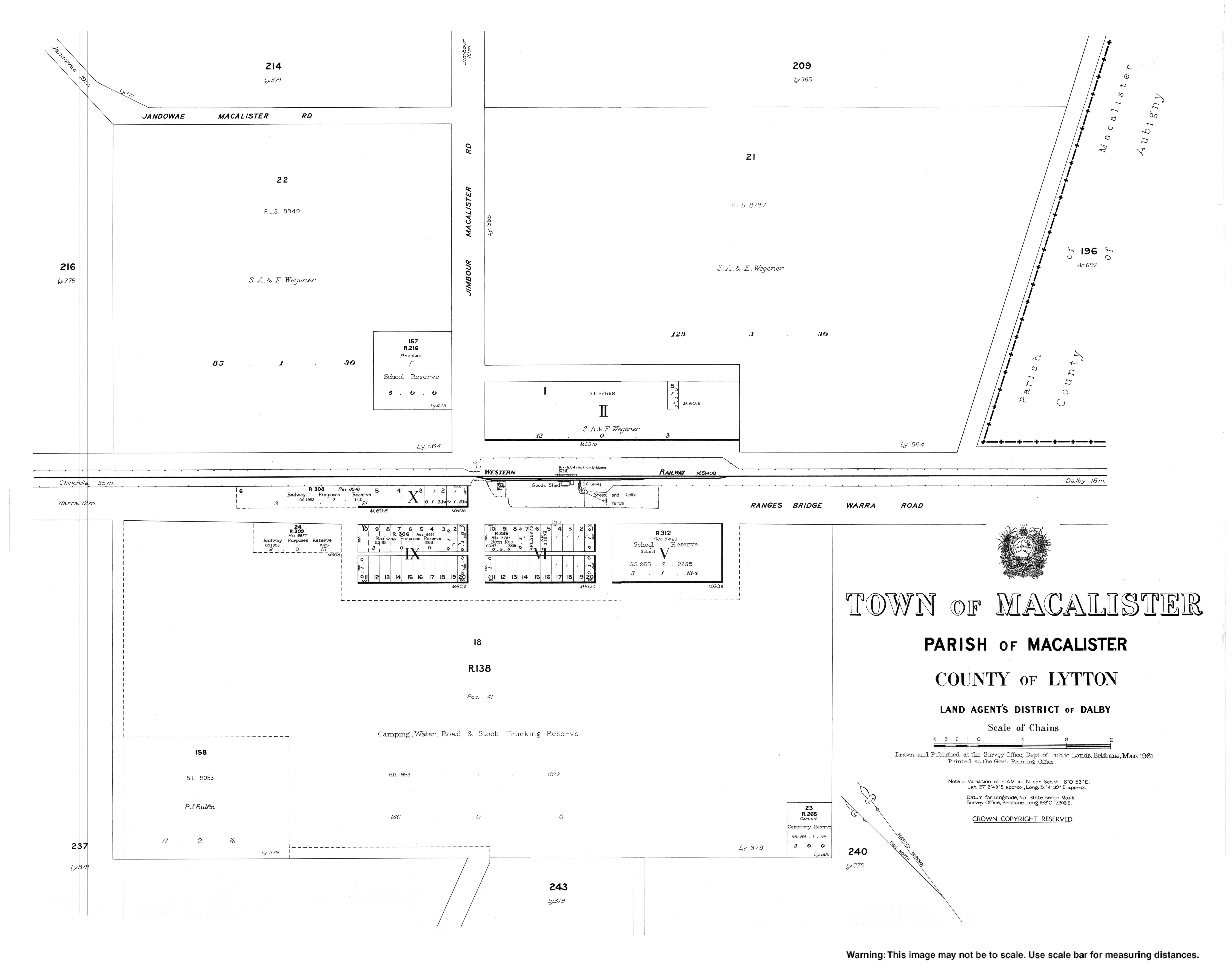
- "Town of Macalister" (Map). Queensland Government. 1961. Archived from the original on 17 September 2017. Retrieved 13 November 2021.
- Australian Bureau of Statistics (25 October 2007). "Macalister (Wambo Shire) (State Suburb)". 2006 Census QuickStats. Retrieved 31 March 2009.
- "Redeemer Lutheran Church". Churches Australia. Archived from the original on 26 October 2020. Retrieved 26 February 2021.
- "Macalister Lutheran Church". South Western Queensland Lutheran Parish. Archived from the original on 29 November 2020. Retrieved 26 February 2021. - "Branch Locations". Queensland Country Women's Association. Archived from the original on 26 December 2018. Retrieved 26 December 2018.
External links
- "Town map of Macalister". Queensland Government. 1961.
Другой контент может иметь иную лицензию. Перед использованием материалов сайта WikiSort.org внимательно изучите правила лицензирования конкретных элементов наполнения сайта.
WikiSort.org - проект по пересортировке и дополнению контента Википедии