world.wikisort.org - Armenia
Tegh (Armenian: Տեղ) is a village and the center of the Tegh Municipality of the Syunik Province in Armenia. Tegh is the last village on the Goris-Stepanakert Highway before passing the border with the Republic of Artsakh.
Tegh
Տեղ | |
|---|---|
 | |
 Tegh  Tegh | |
| Coordinates: 39°33′17″N 46°28′33″E | |
| Country | |
| Province | Syunik |
| Municipality | Tegh |
| Population (2011)[1] | |
| • Total | 2,443 |
| Time zone | UTC+4 (AMT) |
| Tegh at GEOnet Names Server | |
Of significance in the village, are the dozens of visible caves present near Tegh. The village is underlaid by a soft stone layer of porous rock, replete with rows of caves that were once used for human habitation, now largely used for animals. There are also some very large ones facing highway M12. Rows of them are visible from the highway while driving east.
Demographics
Population
The Statistical Committee of Armenia reported its population was 2,520 in 2010,[2] up from 2,333 at the 2001 census.[3]
Gallery
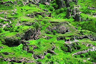 "Cave City" in Tegh
 Residential complex "Amarath" of the Melik-Barkhudaryans (1783)
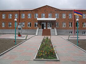 School in Tegh
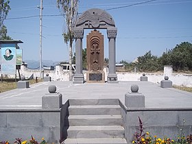 Khachkar monument in memory of the victims of the First Nagorno-Karabakh War
 Saint George's Church in Tegh


References
- Statistical Committee of Armenia. "The results of the 2011 Population Census of Armenia" (PDF).
- "Marzes of Armenia and Yerevan City in Figures, 2010" (PDF). Statistical Committee of Armenia.
- Report of the results of the 2001 Armenian Census, Statistical Committee of Armenia
Capital: Kapan | |||||||
| Urban municipalities |  | ||||||
| Rural municipalities |
| ||||||
This article about a location in Syunik Province, Armenia is a stub. You can help Wikipedia by expanding it. |
На других языках
- [en] Tegh
[ru] Тех
Тех (арм. Տեղ ранее Дыг[1]) — село в восточной части Сюникской области в Армении, в 88 км от города КапанДругой контент может иметь иную лицензию. Перед использованием материалов сайта WikiSort.org внимательно изучите правила лицензирования конкретных элементов наполнения сайта.
WikiSort.org - проект по пересортировке и дополнению контента Википедии