world.wikisort.org - Armenia
Khnatsakh (Armenian: Խնածախ) is a village in the Tegh Municipality of the Syunik Province in Armenia. Khnatsakh is known for being one of the ancient residences of the Kashatagh meliks and contains the partially ruined palace of Melik Hakhnazar I.[3][4]
Khnatsakh
Խնածախ | |
|---|---|
 Saint Hripsime and Khnatsakh skyline | |
 Khnatsakh  Khnatsakh | |
| Coordinates: 39°36′13″N 46°23′34″E | |
| Country | |
| Province | Syunik |
| Municipality | Tegh |
| Area | |
| • Total | 29.41 km2 (11.36 sq mi) |
| Population (2011)[2] | |
| • Total | 998 |
| • Density | 34/km2 (88/sq mi) |
| Time zone | UTC+4 (AMT) |
| Khnatsakh at GEOnet Names Server | |
History

Melikdom of Kashatagh
The Melikdom of Kashatagh was founded at the end of the 15th century by Melik Haykaz I, also the founder of the Melik-Haykazyan dynasty (the youngest branch of the Armenian princely dynasty of Proshyan). Previously, the Kashatagh region was first ruled by the Orbelian family, and then by the Shahurnetsi clan.[5] Haykaz I was succeeded by his son, Hakhnazar I, who died in 1551. Hakhnazar's grave survived until the 1930s.[6]
One of the ancient residences of the Kashatagh meliks is located in Khnatsakh and contains the partially ruined palace of Melik Hakhnazar I.[3][4] Another palace of Melik Haykaz I,[7] built in the late 15th century, is located close to the village of Melikashen (today Hüsülü), near the Tsitsernavank Monastery.[4]
The names of Melik Hakhhnazar and his brother Haykaz (who is also mentioned in the document of 1691/92 as one of the witnesses) are part of the 1682 inscription on the facade of the entrance to the Church of the Holy Virgin in the village of Mirik.[6]
Demographics
Population
The Statistical Committee of Armenia reported its population as 1,073 in 2010,[8] up from 1,021 at the 2001 census.[9]
Gallery
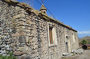 Saint Hripsime Church, Khnatsakh
 WWII memorial in Khnatsakh
 Door of Saint Hripsime Church, Khnatsakh
 Cliff dwellings
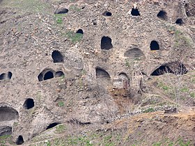 Cliff dwellings
 View of the village


References
- "Syunik regional e-Governance System" (in Armenian). Syunik Province provincial government. Click on link entitled "Համայնքներ" (community) and search for the place by Armenian name.
- Statistical Committee of Armenia. "The results of the 2011 Population Census of Armenia" (PDF).
- Карагезян А. К локализации гавара Кашатаг // Вестн. обществ. наук АН АрмССР. 1987. № 1. С. 44—45.
- Artak Ghulyan. "Castles (Palaces) Of Meliks Of Artsakh And Siunik".
- Hewsen, Robert. "The Meliks of Eastern Armenia: A Preliminary Study." Revue des Études Arméniennes. NS: IX, 1972, pp. 297-308.
- Кристине Костикян «Քաշաթաղի 17-րդ դարի պատմությանը վերաբերող մի փաստաթուղթ» (Документ относящийся к истории Кашатага в 17 веке) из «Страны и народы Ближнего Среднего Востока. Том XX», стр. 168—171. Институт востоковедения Национальной Академии наук Армении; Ереван, 2001.
- Maghalyan A. V., PhD in History (2015). "Falsification Of The History Of The Artsakh Meliqdoms By Azerbaijani Historiography" (PDF).
- "Marzes of Armenia and Yerevan City in Figures, 2010" (PDF). Statistical Committee of Armenia.
- Report of the results of the 2001 Armenian Census, Statistical Committee of Armenia
Capital: Kapan | ||||||||||||
| Urban municipalities |
|  | ||||||||||
| Rural municipalities |
| |||||||||||
На других языках
- [en] Khnatsakh
[ru] Хнацах (Сюник)
Хнацах (арм. Խնածախ) — село в Сюникской области Армении, в 89 км к северо-востоку от областного центра, город Капан. Высота от уровня моря 1380—1460 м, расстояние от города Горис — 31 км.Другой контент может иметь иную лицензию. Перед использованием материалов сайта WikiSort.org внимательно изучите правила лицензирования конкретных элементов наполнения сайта.
WikiSort.org - проект по пересортировке и дополнению контента Википедии