world.wikisort.org - USA
West Pottsgrove Township is a township in Montgomery County, Pennsylvania, United States. The population was 3,874 at the 2010 census.
West Pottsgrove Township | |
|---|---|
Township | |
 High Street in Stowe | |
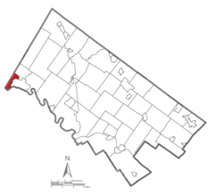 Location of West Pottsgrove Township in Montgomery County | |
 Location of PA in the United States | |
| Coordinates: 40°15′17″N 75°40′42″W | |
| Country | United States |
| State | Pennsylvania |
| County | Montgomery |
| Area | |
| • Total | 2.35 sq mi (6.10 km2) |
| • Land | 2.32 sq mi (6.02 km2) |
| • Water | 0.03 sq mi (0.08 km2) |
| Elevation | 220 ft (70 m) |
| Population (2010) | |
| • Total | 3,874 |
| • Estimate (2016)[2] | 3,882 |
| • Density | 1,670.40/sq mi (644.83/km2) |
| Time zone | UTC-5 (EST) |
| • Summer (DST) | UTC-4 (EDT) |
| Area code(s) | 610 |
| Website | https://westpottsgrove.org/ |
Geography
According to the United States Census Bureau, the township has a total area of 2.4 square miles (6.2 km2), of which 2.3 square miles (6.0 km2) is land and 0.1 square miles (0.26 km2), or 2.08%, is water. It is drained by the Schuylkill River, which separates it from Chester County. Its villages include Stowe and Upper Glasgow.
Neighboring municipalities
- Upper Pottsgrove Township (northeast)
- Pottstown (southeast)
- North Coventry Township, Chester County (south)
- Union Township, Berks County (tangent to the southwest)
- Douglass Township, Berks County (northwest)
Demographics
| Historical population | |||
|---|---|---|---|
| Census | Pop. | %± | |
| 1930 | 2,400 | — | |
| 1940 | 2,605 | 8.5% | |
| 1950 | 3,007 | 15.4% | |
| 1960 | 3,501 | 16.4% | |
| 1970 | 4,038 | 15.3% | |
| 1980 | 4,208 | 4.2% | |
| 1990 | 3,829 | −9.0% | |
| 2000 | 3,815 | −0.4% | |
| 2010 | 3,874 | 1.5% | |
| 2020 | 3,798 | −2.0% | |
| [3] | |||
As of the 2010 census, the township was 83.7% White, 9.5% Black or African American, 0.3% Native American, 0.6% Asian, and 2.9% were two or more races. 3.3% of the population were of Hispanic or Latino ancestry.[4]
At the 2000 census there were 3,815 people, 1,524 households, and 1,010 families living in the township. The population density was 1,622.0 people per square mile (626.8/km2). There were 1,606 housing units at an average density of 682.8/sq mi (263.9/km2). The racial makeup of the township was 89.28% White, 7.21% African American, 0.18% Native American, 0.84% Asian, 0.03% Pacific Islander, 0.81% from other races, and 1.65% from two or more races. Hispanic or Latino of any race were 2.18%.[5]
There were 1,524 households, 29.9% had children under the age of 18 living with them, 52.2% were married couples living together, 10.7% had a female householder with no husband present, and 33.7% were non-families. 27.2% of households were made up of individuals, and 9.6% were one person aged 65 or older. The average household size was 2.50 and the average family size was 3.08.
The age distribution was 24.6% under the age of 18, 7.7% from 18 to 24, 32.3% from 25 to 44, 22.0% from 45 to 64, and 13.5% 65 or older. The median age was 36 years. For every 100 females there were 92.9 males. For every 100 females age 18 and over, there were 91.7 males.
The median household income was $42,759 and the median family income was $52,177. Males had a median income of $32,912 versus $28,949 for females. The per capita income for the township was $18,413. About 5.8% of families and 7.7% of the population were below the poverty line, including 8.7% of those under age 18 and 7.3% of those age 65 or over.
Government and politics

West Pottsgrove Township is governed by a five-member Board of Commissioners. As of 2022, the Board of Commissioners is composed of:[6]
- President Steve Miller
- Vice President Tom Palladino
- Charlie Valentine
- Pete La Rosa
- Mark Green
| Year | Republican | Democratic |
|---|---|---|
| 2020 | 48.0% 858 | 50.0% 888 |
| 2016 | 50.6% 769 | 43.0% 669 |
| 2012 | 43.8% 623 | 53.8% 764 |
| 2008 | 37.2% 555 | 61.2% 912 |
| 2004 | 42.2% 589 | 57.2% 799 |
| 2000 | 42.2% 456 | 54.2% 585 |
| 1996 | 34.1% 324 | 49.3% 468 |
| 1992 | 32.4% 364 | 44.4% 498 |
References
- "2016 U.S. Gazetteer Files". United States Census Bureau. Retrieved Aug 14, 2017.
- "Population and Housing Unit Estimates". Retrieved June 9, 2017.
- "Census 2020".
- Census 2010: Pennsylvania. Usatoday.Com. Retrieved on 2013-07-21.
- "U.S. Census website". United States Census Bureau. Retrieved 2008-01-31.
- "Board of Commissioners". West Pottsgrove Township. Retrieved January 9, 2022.
- "Montco Election Results".
External links
Municipalities and communities of Montgomery County, Pennsylvania, United States | ||
|---|---|---|
County seat: Norristown | ||
| Boroughs |
|  |
| Townships |
| |
| CDPs |
| |
| Other communities |
| |
| Footnotes | ‡This populated place also has portions in an adjacent county or counties | |
| ||
Authority control | |
|---|---|
| General | |
| National libraries | |
Другой контент может иметь иную лицензию. Перед использованием материалов сайта WikiSort.org внимательно изучите правила лицензирования конкретных элементов наполнения сайта.
WikiSort.org - проект по пересортировке и дополнению контента Википедии