world.wikisort.org - USA
Twin Falls is the county seat and largest city of Twin Falls County, Idaho, United States.[7] The city had a population of 51,807 as of the 2020 census.[8] In the Magic Valley region, Twin Falls is the largest city in a one-hundred-mile (160 km) radius, and is the regional commercial center for south-central Idaho and northeastern Nevada.[9] It is the principal city of the Twin Falls Metropolitan Statistical Area, which officially includes the entirety of Twin Falls and Jerome counties.[10] The border town resort community of Jackpot, Nevada, fifty miles (80 km) south at the state line, is unofficially considered part of the greater Twin Falls area.[11] Located on a broad plain at the south rim of the Snake River Canyon, Twin Falls is where daredevil Evel Knievel attempted to jump across the canyon in 1974 on a steam-powered rocket. The jump site is northeast of central Twin Falls, midway between Shoshone Falls and the Perrine Bridge.
Twin Falls, Idaho | |
|---|---|
City | |
 Downtown Twin Falls in 2016 | |
 Seal | |
| Motto: People Serving People | |
 Location of Twin Falls in Twin Falls County, Idaho. | |
 Twin Falls, Idaho Location in the United States | |
| Coordinates: 42°33′20″N 114°28′15″W | |
| Country | United States |
| State | Idaho |
| County | Twin Falls |
| Incorporated | April 12, 1905 |
| Government | |
| • Type | council-manager |
| • Mayor | Ruth Pierce [1] |
| • City Manager | Travis Rothweiler[2] |
| Area | |
| • City | 19.47 sq mi (50.43 km2) |
| • Land | 19.36 sq mi (50.13 km2) |
| • Water | 0.11 sq mi (0.30 km2) |
| Elevation | 3,734 ft (1,138 m) |
| Population (2020)[5] | |
| • City | 51,807 |
| • Estimate (2019)[6] | 50,197 |
| • Density | 2,593.49/sq mi (1,001.34/km2) |
| • Metro | 106,508 |
| Time zone | UTC-7 (MST) |
| • Summer (DST) | UTC-6 (MDT) |
| ZIP Code | 83301 (street addresses) 83303 (PO Boxes) |
| Area code(s) | 208, 986 |
| FIPS code | 16-82810 |
| GNIS feature ID | 0398273[4] |
| Interstate | |
| U.S. Route(s) | |
| Website | http://www.tfid.org |
History
Excavations at Wilson Butte Cave near Twin Falls in 1959 revealed evidence of human activity, including arrowheads, that rank among the oldest dated artifacts in North America.[12] Later Native American tribes predominant in the area included the Northern Shoshone and Bannock.[13]
The first people of European ancestry to visit the Twin Falls area are believed to be members of a group led by American Wilson Price Hunt, which attempted to blaze an all-water trail westward from St. Louis, Missouri, to Astoria, Oregon, in 1811 and 1812. Hunt's expedition met with disaster: much of his expedition was destroyed and one man was killed in rapids on the Snake River known as Caldron Linn near present-day Murtaugh. Hunt and the surviving members of his expedition completed the journey to Astoria by land.[14]
In 1812 and 1813, Robert Stuart successfully led an overland expedition eastward from Astoria to St. Louis, which passed through the Twin Falls area. Stuart's route formed the basis of what became the Oregon Trail.[15] Some 150 years later, Robert Stuart Middle School in Twin Falls was named in his honor.


The first permanent settlement in the area was a stage stop established in 1864 at Rock Creek near the present-day townsite.[16] By 1890 there were a handful of successful agricultural operations in the Snake River Canyon, but the lack of infrastructure and the canyon's geography made irrigating the dry surrounding area improbable at best.
To address this issue, in 1900 I. B. Perrine founded the Twin Falls Land and Water Company, largely to build an irrigation canal system for the area. After an August 1900 area survey of 244,025 acres (98,753 hectares), in October 1900 the company was granted the necessary water rights to begin construction of the irrigation system. Several lots in the surveyed area were set aside specifically for future townsites. These lots eventually became the settlements of Twin Falls, Kimberly, Buhl, Filer, Hansen and Murtaugh. In 1902, the project nearly failed as most of the original investors pulled out, with only Salt Lake businessman Stanley Milner maintaining a stake in the company.[17]
By 1903, Perrine, who had been a successful farmer and rancher in the Snake River Canyon, had obtained private financing from Milner and others under the provisions of the Carey Act of 1894 to build a dam on the Snake River near Caldron Linn. Completed in 1905, Milner Dam and its accompanying canals made commercial irrigation outside the Snake River Canyon practical for the first time.[18] As a result, Perrine is generally credited as the founder of Twin Falls.[19]
A land drawing was held for the future townsite in July 1903 with disappointing results. A much more successful drawing was held in October 1904.[17] Twin Falls city was founded in 1904 as a planned community, designed by celebrated Franco-American architect Emmanuel Louis Masqueray, with proceeds from sales of townsite lots going toward construction of irrigation canals. Twin Falls was incorporated as a village on April 12, 1905.[20] The city is named for a nearby waterfall on the Snake River of the same name. In 1907, Twin Falls became the seat of the newly formed Twin Falls County.
The original townsite follows a unique design. It is laid out on northeast-to-southwest and northwest-to-southeast roads. It is purported that the reason this was done was to allow sunlight to come into every room in the home at some point during the day. The northwest-to-southeast roads were numbered and called avenues, while the northeast-to-southwest roads were numbered and called streets. Only two central streets, the northwest-to-southeast Main Avenue and the northeast-to-southwest Shoshone Street, were named. This system created situations where one side of a street may have an entirely different address than the other, and where the corner of "3rd and 3rd," for example, was in more than one location. In 2003 the numbered northeast-to-southwest streets were renamed to alleviate decades of confusion. Later city roads, such as Blue Lakes Boulevard, Addison Avenue, and Washington Street, are laid out in standard north–south and east–west orientations. Addison Avenue honors Addison T. Smith (1862–1956), a ten-term congressman (1913–33) from Twin Falls.
After Milner Dam was constructed agricultural production in south-central Idaho increased substantially. In 1909, the privately owned Twin Falls Land and Water Company was reorganized as the shareholder-owned Twin Falls Canal Company.[17] Twin Falls became a major regional economic center serving the agriculture industry, a role which it has sustained to the present day. The city became a processing center for several agricultural commodities, notably beans and sugar beets. In later years other food processing operations augmented the local economy. By 1960, Twin Falls had become one of Idaho's largest cities even though its origins were still within living memory for many.
Twin Falls became the center of national attention 48 years ago in September 1974, when daredevil Evel Knievel attempted to jump the Snake River Canyon in a specially modified rocket cycle. Watched by millions on closed-circuit television on a Sunday afternoon, the attempt ultimately failed due to high winds and a premature deployment of Knievel's parachute.[22][23][24][25] The launch ramp's foundation lies on private land on the canyon's south rim. Less than two miles west (3 km) of Shoshone Falls, it is still visible (42.597°N 114.423°W).
During the last quarter of the 20th century, gradual diversification of the agriculture-based economy allowed the city to continue to grow. Major Twin Falls employers in 2006 included computer maker Dell, Inc., Glanbia, and Jayco, a recreational vehicle manufacturer. In September 2009, Dell announced it would close its Twin Falls facility by January 2010.[26] Later in 2010, the call center company C3 opened a facility in the former Dell location.[27]
In recent years, Twin Falls has become quite multicultural. Thanks in large part to a refugee center operated by the College of Southern Idaho, since 1995 significant numbers of people from Bosnia and Herzegovina and the former Soviet Union have settled in Twin Falls. The city also has a sizable Hispanic population.
Government
Twin Falls is one of only three Idaho cities which has a council-manager form of government.[28] The seven-member Twin Falls City Council is directly elected in non-partisan municipal elections to four-year terms. The mayor, who holds little executive power, is periodically selected among current city council members to chair meetings and is "considered the official representative of the city." City council meetings are usually held on Mondays.[29]
The city's day-to-day operations are overseen by a city manager, who is appointed by the city council. The city government through various citizen boards oversees parks and recreation, planning and zoning, sanitation and garbage collection, street maintenance, wastewater collection, and maintains police and fire departments. Twin Falls Public Library, Twin Falls Municipal Golf Course and Joslin Field-Magic Valley Regional Airport are also under the city's jurisdiction.
Higher education
Twin Falls is home to the College of Southern Idaho (CSI), a large community college in the northwestern part of the city. The three state universities (Boise State University, Idaho State University, and the University of Idaho) offer classes on the CSI campus. The nursing program received money from the 2007-2008 state budget to construct a state of the art nursing facility which complements the nursing program.[30] The CSI men's basketball team won its third NJCAA Division I Championship in March 2011.[31]
Primary and secondary schools
Public schools are administered by the Twin Falls School District, including Twin Falls High School, Canyon Ridge High School, the alternative Magic Valley High School, three middle schools and nine elementary schools. The superintendent of these is Brady Dickinson and assistant superintendent Bill Brulotte. Also, Twin Falls is home to Xavier Charter School and the district was awarded best title 1C district in the state.[32]
On March 14, 2006, registered voters approved a bond to build an additional high school. A citywide contest was held to determine the school's nickname. In November 2006, the Twin Falls School Board selected "River Hawks," thus officially giving birth to the Canyon Ridge High School River Hawks. Also on the bond were plans to make general improvements to existing school facilities and to convert the junior high schools to middle schools. These projects were completed for the 2009–10 school year. The addition of Canyon Ridge High School meant that the student population was split nearly in half. Athletics for both schools are designated 4A rather than 5A by IHSAA[33][34]
Elementary schools
- Bickel Elementary School (K-5)
- Harrison Developmental Preschool
- Harrison Elementary School (K-5)
- I.B. Perrine Elementary School (preschool and K-5)
- Lincoln Elementary School (K-5)
- Morningside Elementary School (K-5)
- Oregon Trail Elementary School (K-5)
- Pillar Falls Elementary School (K-5)
- Sawtooth Elementary School (K-5)
- Rock Creek Elementary School (K-5)
Middle schools
- O'Leary Middle School (6-8)
- Robert Stuart Middle School (6-8)
- Bridge Academy (Alternative 6-8)
- South Hills Middle School (6-8)
High schools
- Canyon Ridge High School (9-12)
- Twin Falls High School (9-12)
Alternative high schools
- Magic Valley High School (9-12)
Private schools include Lighthouse Christian School, Xavier Charter School, St. Edward's Catholic School and Twin Falls Christian Academy. [35]
Economy
Twin Falls, the state's 7th largest city, is the fastest growing city in South-Central Idaho.[36] As of April 2011 unemployment in Twin Falls county stood at 9.5%, below Idaho's average of 9.6%. From 1998 to 2007 the unemployment rate was steadily decreasing, to a low of just under 2%. Then, in tandem with the national economy, the unemployment rate increased to nearly 9.5% as of April 2011.[37]
Twin Falls is the home of cheese producer Glanbia Foods, a major American division of the Irish food company Glanbia plc.[38]
Falls Brand, another award-winning food company, is located in the southern part of Twin Falls. In early 2011, Falls Brands' Old Fashioned Basque Chorizo sausage won the "Hold The Mustard" award presented by the National Meat Association (NMA) every year during their annual "NMA Annual Gourmet Sausagefest."[39]
Another mainstay is The College of Southern Idaho (CSI). Boasting a student-population of 3,433 students, this Junior College may be an alternative for students not yet ready to attend a four-year university. Many students are from out-of-state and live in CSI's residential halls.[40]
Other large employers include Amalgamated Sugar Company, makers of White Satin sugar;[41] and Lamb Weston, which has a food processing plant located in west Twin Falls. It employs 500 residents and its annual revenue is about $100 million per annum.[42]
In spite of a troubled national economy, Twin Falls has seen rapid development since 2006. Many major retail outlets have opened stores in Twin Falls between 2006 and 2011.[43]
In November 2009, a new Walmart Supercenter opened, bringing to the region an estimated 100 additional jobs.[44] Less than a year later, in October 2010, C3, a customer call center, opened in the former Dell facility. It was a large boost to an already busy economy, providing close to 1,000 jobs.[45] In July 2011 C3 announced it was filling another 300 C3 jobs in Twin Falls due to brisk business.[46]
Creating 40-50 new jobs, Magic Valley Cinema 13 constructed a new theater equipped with D-BOX seating. The new entertainment center was developed in association with the unprecedented growth in the Magic Valley.[47]
In response to a growing population base, Twin Falls County voters voted to construct a new hospital in the northwest section of Twin Falls to replace the city's existing hospital. In spring 2011 the new 700,000 sq/ft. facility, St. Luke's Magic Valley, was opened. One of the features of the new hospital is that all 186 rooms are private with family accommodations.[48][49]
Other businesses which have recently opened locations in Twin Falls include Five Guys Burgers and Fries,[50] Buffalo Wild Wings,[51] and Coldwater Creek.[47] Wanting to catch some momentum a movement has begun to rebuild downtown in hopes of moving some business back to where it originated.[52]
Twin Falls hosted the 2012 Idaho Republican Party convention, which was expected to create more positive economic activity.[53]
China Mountain Wind, LLC. has proposed and may construct a 300,000 acres (1,200 km2) wind farm after the Environmental Impacts are weighed. Twin Falls County can expect to generate $33.4 million in tax revenues. Local schools and services will receive a portion of the tax revenue. The construction of the wind farm will bring to the area 396-749 full and part-time jobs during construction and 24-46 new jobs to maintain the facility.[54]
Chobani Yogurt Company, in 2012, opened the world's largest yogurt manufacturing plant providing an additional 300 jobs to the Twin Falls community.[55]
Media
The Times-News is a local daily morning newspaper based in Twin Falls.
Over-the-air television stations include:
- KMVT (CBS)
- KSVT-LD (CW) (digital substation)
- KTID (MyNetworkTV and Mexicanal) (digital substation)
- KIPT (PBS)
- KXTF (TCT)
- KTFT (NBC, semi-satellite of KTVB, Boise)
- KSAW-LD (ABC, semi-satellite of KIVI-TV, Boise)
- KYTL
Cable television subscribers also receive stations from Boise and Salt Lake City, Utah.
A number of radio stations broadcast in the Twin Falls area, including (but not limited to):
- 88.1 KTFY - The Bridge (Christian Worship Music)[56]
- 88.9 KEFX - The Effect Radio Network (Modern Christian rock with over 60 stations nationwide)
- 89.9 KAWZ - CSN International (Biblical teaching with over 400 stations nationwide)
- 92.7 KTPZ - The Music Monster (Top 40)
- 95.7 KEZJ - Idaho Country (Country)
- 96.5 KLIX-FM - Kool Oldies (Oldies)
- 98.3 KSNQ - The Snake (Classic Rock)
- 99.1 KXTA - La Perrona (Regional Mexican)
- 99.9 KZDX - Hot 100 FM (Adult contemporary/Top 40)
- 102.1 KIRQ - IRock (Modern rock)
- 103.1 KEDJ - The Edge (Rock)
- 103.7 KSKI (Modern rock)
- 103.9 KDKI-LP - (Adult standards/Big band/Jazz)
- 104.7 KIKX (Adult hits)
- 106.1 KKMV - Kat Kountry (Country)
- 106.7 KYUN - Canyon Country (Country)
- 970 KFTA - Juan 970 (Regional Mexican)
- 1310 KLIX - News and Talk
Twin Falls had the first live call-in radio show in the United States.[citation needed] Called "Party Line," the show was hosted by L. James Koutnik on KLIX. The FCC attempted to time delay the program, but Koutnik and station owner Charlie Tuma thwarted their efforts and continued to allow live callers on the air.[57]
Transportation
Twin Falls is the largest city in Idaho that is not directly on the Interstate Highway System; it is served by several major highways, including U.S. Route 30 and U.S. Route 93. Access to nearby Interstate 84 is across the canyon via the Perrine Bridge (U.S. 93); the junction is approximately five miles (8 km) north, in Jerome County. State Highway 74 provides direct access from downtown Twin Falls to southbound locations on U.S. 93, including Hollister and Rogerson, then crosses into Nevada at Jackpot and continues to a junction with Interstate 80 at Wells.
Trans IV, a small public transportation system operated by the College of Southern Idaho, is also available.[58]
Limited commercial air service is provided at Magic Valley Regional Airport, also known as Joslin Field. As of August 2017, daily flights to Salt Lake City are available from Delta Connection (fulfilled by SkyWest Airlines) using the Canadair CRJ200.[59] Twice-weekly service to Las Vegas was previously operated by Allegiant Air, but the airline discontinued the route in January 2012, citing insufficient ticket prices.[60]
Geography
Twin Falls is located at 42°34'N 114°28'W (42.561,-114.464).
According to the United States Census Bureau, the city has a total area of 18.16 square miles (47.03 km2), of which, 18.10 square miles (46.88 km2) is land and 0.06 square miles (0.16 km2) is water.[61]
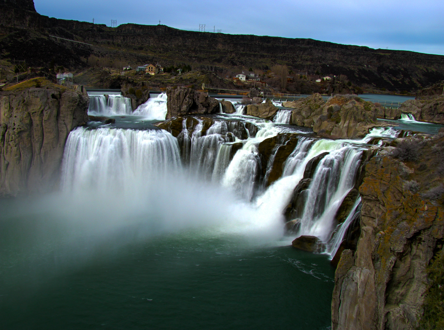
The Snake River Canyon forms the city's northern limits, separating it from Jerome County. There are three waterfalls in the immediate area. Shoshone Falls is located approximately 5 miles (8.0 kilometres) east of Twin Falls city. Pillar Falls is located approximately 1+1⁄2 mi (2+1⁄2 km) upstream from the Perrine Bridge while Twin Falls, the city's namesake, is located upstream of Shoshone Falls.
Shoshone Falls stands at 213 ft (65 m), which is 46 feet (14 m) higher than Niagara Falls.

The Perrine Bridge, which spans the Snake River Canyon immediately north of the city, is one of only a handful of artificial structures worldwide where BASE jumping is legal. In September 2005 Miles Daisher of Twin Falls set a BASE jumping world record by jumping off Perrine Bridge 57 times in a 24-hour period. In July 2006 Dan Schilling jumped off the bridge 201 times in 21 hours to raise money for charity. Unlike Daisher, Schilling was hoisted to the top of the bridge by a crane after every jump.[62]
Climate
Twin Falls experiences a semi-arid climate (Köppen climate classification, BSk).
Monthly temperature averages in Twin Falls range from 27.0 °F (−2.8 °C) in January to 68.9 °F (20.5 °C) in July, with lows below freezing from December through March. Highs reach 90 °F (32 °C) on average 18.8 days per year,[63] but very rarely exceed 100 °F (38 °C). Winter snowfall averages 29.5 inches (74.9 cm) per year,[63] though much heavier amounts have fallen. However, in Twin Falls proper after an average snowfall it is uncommon to see more than six inches of snow on streets and sidewalks. Summer and autumn months are very dry in Twin Falls, with less than 1 inch (2.5 cm) inch of precipitation falling each month between June and October. It is not uncommon to experience fast moving, intense electrical storms common in the deserts of the southwestern U.S..
| Climate data for Twin Falls, Idaho | |||||||||||||
|---|---|---|---|---|---|---|---|---|---|---|---|---|---|
| Month | Jan | Feb | Mar | Apr | May | Jun | Jul | Aug | Sep | Oct | Nov | Dec | Year |
| Record high °F (°C) | 63 (17) |
70 (21) |
78 (26) |
91 (33) |
102 (39) |
103 (39) |
110 (43) |
105 (41) |
103 (39) |
90 (32) |
80 (27) |
67 (19) |
110 (43) |
| Average high °F (°C) | 34.9 (1.6) |
41.4 (5.2) |
50.7 (10.4) |
59.5 (15.3) |
67.7 (19.8) |
77.0 (25.0) |
85.0 (29.4) |
84.1 (28.9) |
74.2 (23.4) |
62.5 (16.9) |
46.2 (7.9) |
36.4 (2.4) |
60.0 (15.6) |
| Average low °F (°C) | 19.2 (−7.1) |
23.4 (−4.8) |
28.8 (−1.8) |
33.7 (0.9) |
41.2 (5.1) |
48.0 (8.9) |
52.8 (11.6) |
51.1 (10.6) |
42.8 (6.0) |
34.2 (1.2) |
26.4 (−3.1) |
19.3 (−7.1) |
35.1 (1.7) |
| Record low °F (°C) | −13 (−25) |
−17 (−27) |
4 (−16) |
18 (−8) |
24 (−4) |
31 (−1) |
38 (3) |
37 (3) |
24 (−4) |
11 (−12) |
−2 (−19) |
−21 (−29) |
−21 (−29) |
| Average precipitation inches (mm) | 1.29 (33) |
0.93 (24) |
1.21 (31) |
0.95 (24) |
1.40 (36) |
0.84 (21) |
0.27 (6.9) |
0.38 (9.7) |
0.65 (17) |
0.78 (20) |
1.17 (30) |
1.12 (28) |
10.99 (279) |
| Average snowfall inches (cm) | 7.4 (19) |
5.4 (14) |
3.5 (8.9) |
1.1 (2.8) |
0.7 (1.8) |
0 (0) |
0 (0) |
0 (0) |
0.1 (0.25) |
0.3 (0.76) |
4.1 (10) |
6.9 (18) |
29.5 (75) |
| Average precipitation days (≥ 0.01 in) | 10.2 | 8.6 | 9.9 | 8.6 | 9.0 | 6.4 | 3.3 | 3.6 | 4.2 | 5.8 | 9.3 | 9.3 | 88.2 |
| Average snowy days (≥ 0.1 in) | 6.8 | 4.3 | 3.4 | 1.4 | 0.5 | 0.2 | 0 | 0 | 0.1 | 0.4 | 3.5 | 5.4 | 26 |
| Source: NOAA[63] | |||||||||||||
Demographics
| Historical population | |||
|---|---|---|---|
| Census | Pop. | %± | |
| 1910 | 5,258 | — | |
| 1920 | 8,324 | 58.3% | |
| 1930 | 8,787 | 5.6% | |
| 1940 | 11,851 | 34.9% | |
| 1950 | 17,600 | 48.5% | |
| 1960 | 20,126 | 14.4% | |
| 1970 | 21,914 | 8.9% | |
| 1980 | 26,209 | 19.6% | |
| 1990 | 27,591 | 5.3% | |
| 2000 | 34,469 | 24.9% | |
| 2010 | 44,125 | 28.0% | |
| 2019 (est.) | 50,197 | [6] | 13.8% |
| U.S. Decennial Census[64] | |||
According to 2009 estimates from the United States Census Bureau,[65] the population swelled to 42,741, an increase of nearly 20% from the 2000 United States Census, with an average household size of 3.20 residents. There were 9,422 owner-occupied homes with an average value, as of 2009, of $136,000.
The population density is 3,743 people per square mile. The racial makeup of the city is 92.0% White, 0.5% Black, 0.9% Native American, 1.0% Asian, 0.1% Pacific Islander, 2.9% from other races, and 2.6% from two or more races. Hispanic or Latino of any race were 12.3% of the population.
There were 15,458 households, out of which 34.1% had children under the age of 18 living with them, 49.0% were married couples living together, 12.7% had a female householder with no husband present, and 34.1% were non-families. 26.8% of all households were made up of individuals, and 10.7% had someone living alone who was 65 years of age or older. The average household size was 2.58 and the average family size was 3.20.
In the city, the population was spread out, with 23.5% under the age of 14, 15.6% from 15 to 24, 27.6% from 25 to 44, 20.2% from 45 to 64, and 13.4% who were 65 years of age or older. The median age was 31.2 years. For every 100 females, there were 95.8 males.
The median income for a household in the city was $40,970 and the mean income for a family was $49,295.
2010 census
As of the census[5] of 2010, there were 44,125 people, 16,744 households, and 11,011 families residing in the city. The population density was 2,437.8 inhabitants per square mile (941.2/km2). There were 18,033 housing units at an average density of 996.3 per square mile (384.7/km2). The racial makeup of the city was 88.5% White, 0.7% African American, 0.8% Native American, 1.8% Asian, 0.1% Pacific Islander, 5.7% from other races, and 2.6% from two or more races. Hispanic or Latino of any race were 13.1% of the population.
There were 16,744 households, of which 35.1% had children under the age of 18 living with them, 48.3% were married couples living together, 12.2% had a female householder with no husband present, 5.2% had a male householder with no wife present, and 34.2% were non-families. 26.6% of all households were made up of individuals, and 10.9% had someone living alone who was 65 years of age or older. The average household size was 2.58 and the average family size was 3.13.
The median age in the city was 31.9 years. 27% of residents were under the age of 18; 11.7% were between the ages of 18 and 24; 26.5% were from 25 to 44; 21.4% were from 45 to 64; and 13.4% were 65 years of age or older. The gender makeup of the city was 48.7% male and 51.3% female.
Rankings
On the Livability.com list of "Best 10 Places to Defy Death",[66] Twin Falls ranked No. 1.
Notable people
- Bruce Bastian (born 1948), computer programmer and co-founder of the WordPerfect Software Company
- Gary L. Bennett (born 1940), former NASA scientist and engineer and science fiction writer
- Jim Boatwright (1951–2013), basketball player
- Dorothy Custer (1911–2015), comedian, harmonicist, and centenarian
- W. Mark Felt (1913–2008), informant in the Watergate scandal known as Deep Throat, graduated from Twin Falls High School in 1931
- Christina Hendricks (born 1975), actress, grew up in Twin Falls
- Damon Jones (born 1994), professional baseball pitcher
- Chuck LaMar (born c. 1956), first general manager of the Tampa Bay Devil Rays
- William J. Lanting (1918–1998), Idaho State Representative (1959–1975) and Speaker of Idaho House (1969–1975)
- Craig Hart Neilsen (1941–2006), founder of the Craig H. Neilsen Foundation to fund scientific research for spinal cord injuries
- Volara Romanza Nelson (1892–1921), first Idaho woman to hold a pilot's license
- Melvin Schwartz (1932–2006), Nobel Prize-winning experimental physicist and co-discoverer of the muon neutrino
- Addison T. Smith (1862–1956), U.S. Congressman (1913–1933)
- Lyda Southard (1892–1958), serial killer
Notable musicians who spent parts of their childhood in the Twin Falls area include Gary Puckett, Paul Durham of Black Lab, Nikki Sixx of Mötley Crüe, and Doug Martsch of Built to Spill.
References
- Brown, Nathan. "Barigar Picked as New Twin Falls Mayor", Times-News, January 5, 2016. (Retrieved January 5, 2016)
- Twin Falls, ID - Official Website - City Manager Archived March 27, 2015, at the Wayback Machine (Retrieved January 17, 2012)
- "2019 U.S. Gazetteer Files". United States Census Bureau. Retrieved July 9, 2020.
- U.S. Geological Survey Geographic Names Information System: Twin Falls, Idaho
- "U.S. Census website". United States Census Bureau. Retrieved December 18, 2012.
- "Population and Housing Unit Estimates". United States Census Bureau. May 24, 2020. Retrieved May 27, 2020.
- "Find a County". National Association of Counties. Archived from the original on July 4, 2012. Retrieved June 7, 2011.
- Twin Falls (city) QuickFacts from the US Census Bureau Archived January 1, 2012, at the Wayback Machine (Retrieved January 17, 2012)
- City of Twin Falls Comprehensive Plan Update Retrieved May 7, 2007 Archived September 12, 2008, at the Wayback Machine
- Twin Falls designated as metropolitan area years earlier than expected Retrieved January 7, 2018
- Twin Falls visitidaho.org Archived August 23, 2010, at the Wayback Machine Retrieved May 7, 2007
- BLM.gov Retrieved January 16, 2010 Archived September 26, 2012, at the Wayback Machine
- Northern Shoshone and Bannock Economy Retrieved May 7, 2007
- The Fur Trade Explorers Retrieved May 7, 2007
- The Astorians Retrieved May 7, 2007 Archived September 1, 2012, at the Wayback Machine
- Rock Creek Station and Stricker Homesite Retrieved May 7, 2007 Archived October 16, 2015, at the Wayback Machine
- Smith, Paul. The History of Twin Falls (Retrieved January 17, 2012)
- Ira Burton Perrine Retrieved May 7, 2007
- Times-News Summer Fun Guide[dead link] Retrieved May 7, 2007
- Welcome to Twin Falls County, Idaho (Retrieved January 17, 2012)
- Jones, Robert F. (September 16, 1974). "We shoulda run one more test". Sports Illustrated: 26.
- Miller, Hack (September 9, 1974). "Evel puzzle: what popped chute?". Deseret News. p. 1C.
- "Jump fails, but Knievel uninjured". Spokesman Review. (New York Times). September 9, 1974. p. 1.
- "Chute system's weakness cited". Spokane Daily Chronicle. Associated Press. September 9, 1974. p. 6.
- Dell to close Twin Falls call center
- C3 to Add 300 Jobs in Twin Falls; Company to Expand into Texas, Arizona Times-News, August 4, 2011. (Retrieved January 17, 2012)
- Wells, Michael. "Lewiston's manager system challenged often, Twin Falls stays quiet", McCall Star-News, July 16, 2009. (Retrieved February 15, 2012)
- Twin Falls, ID - Official Website - City Council (Retrieved February 25, 2014)
- Dream Come True For CSI Nursing Program Archived September 28, 2011, at the Wayback Machine KMVT.com. Retrieved June 10, 2011
- CSI MEN'S BASKETBALL WINS NATIONAL CHAMPIONSHIP (Retrieved January 17, 2012)
- Gallery: Twin Falls Schools Awarded Best Title 1C District in State
- Magicvalley.com
- Canyon Ridge: A new history begins Archived February 27, 2012, at the Wayback Machine
- "Twin Falls School District". Archived from the original on November 17, 2012. Retrieved October 13, 2012.
- Idaho Department of Labor Idaho Department of Labor. Retrieved June 13, 2011
- Google Public Data Retrieved June 13, 2011
- Glanbia Foods Archived October 5, 2011, at the Wayback Machine Glanbia.com. Retrieved June 13, 2011
- NMA Annual Gourmet Sausagefest nmaonline.com. Retrieved June 24, 2011 Archived September 10, 2012, at the Wayback Machine
- Student Housing
- amalgamatedsugar.com Archived October 2, 2011, at the Wayback Machine amalgamatedsugar.com. Retrieved June 13, 2011
- ConAgra-LambWeston manta.com. Retrieved June 24, 2011
- Regional theater chain to build new cinema complex in Magic Valley Mall, Magic Valley website; Retrieved June 13, 2011
- Manta.com Manta.com. Retrieved June 13, 2011
- c3connect.com C3Connect.com. Retrieved June 13, 2011 Archived January 22, 2012, at the Wayback Machine
- C3 to Add 300 Jobs in Twin Falls
- Regional theater chain to build new cinema complex in Magic Valley Mall magicvalley.com Retrieved June 13, 2011
- St. Lukes Online stlukesonline.com. Retrieved June 13, 2011
- MagicValley.com magicvalley.com. Retrieved June 13, 2011
- MagicValley.com magicvalley.com. Retrieved June 13, 2011
- MagicValley.com magicvalley.com. Retrieved June 13, 2011
- MagicValley.com magicvalley.com. Retrieved June 13, 2011
- Twin Falls chosen to be site of 2012 Idaho GOP convention.
- chinamountainwind.com Retrieved 29 June 2011 Archived February 2, 2011, at the Wayback Machine
- Chobani Celebrates Grand Opening of World’s Largest Yogurt Manufacturing Plant in Twin Falls, Idaho | Chobani Foodservice Archived May 29, 2014, at the Wayback Machine
- "Radio Stations in Twin Falls, Idaho". Radio-locator.com. Retrieved January 15, 2016.
- Tuma, Charlie. Personal interview with Debra M. Koutnik. English 102 C20 Freshman Composition 2. March 23, 2004.
- Trans IV Buses
- "Worldwide Timetable" (PDF). delta.com. August 1, 2017. pp. 1458–1459. Retrieved August 12, 2017.
- Botkin, Ben (December 2, 2011). "Allegiant to Terminate Service at Twin Falls Airport". Times-News. Twin Falls, Idaho. Retrieved January 17, 2012.
- "US Gazetteer files 2010". United States Census Bureau. Archived from the original on February 20, 2011. Retrieved December 18, 2012.
- [dead link]
- "Average Weather for Twin Falls, ID - Temperature and Precipitation" (HMTL). The Weather Channel. 2013. Retrieved August 26, 2013.
- "Census of Population and Housing". Census.gov. Retrieved June 4, 2015.
- U.S. census. Retrieved June 10, 2010
- Top Ten Cities to Defy Death Announced by Livability.com newswire.com. Retrieved January 24, 2019
External links
- City of Twin Falls
- Top 10 Things to Do in Twin Falls
- Twin Falls Area Chamber of Commerce
- Twin Falls Idaho Community Site
Municipalities and communities of Twin Falls County, Idaho, United States | ||
|---|---|---|
County seat: Twin Falls | ||
| Cities |  | |
| Unincorporated community | ||
| ||
State of Idaho | |
|---|---|
Boise (capital) | |
| Topics |
|
| Society |
|
| Regions |
|
| Larger cities | |
| Smaller cities | |
| Counties |
|
Authority control | |
|---|---|
| General | |
| Other |
|
На других языках
[de] Twin Falls
Twin Falls ist Sitz der County-Verwaltung (County Seat) und die größte Stadt des Twin Falls County im US-Bundesstaat Idaho. Nach der Volkszählung aus dem Jahr 2020 hat Twin Falls 51.807 Einwohner.- [en] Twin Falls, Idaho
[ru] Туин-Фолс (город, Айдахо)
Туи́н-Фолс[1][2] (англ. Twin Falls) — окружной центр и крупнейший город округа Туин-Фолс штата Айдахо (США).Другой контент может иметь иную лицензию. Перед использованием материалов сайта WikiSort.org внимательно изучите правила лицензирования конкретных элементов наполнения сайта.
WikiSort.org - проект по пересортировке и дополнению контента Википедии