world.wikisort.org - USA
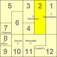
Township 2 is a township in Rooks County, Kansas, United States.
Township 2 | |
|---|---|
Township | |
 Location in Rooks County | |
| Coordinates: 39°26′13″N 99°12′44″W | |
| Country | United States |
| State | Kansas |
| County | Rooks |
| Township 2 | 1971 |
| Elevation | 1,745 ft (532 m) |
| Population (2010) | |
| • Total | 379 |
| Time zone | UTC-6 (CST) |
| GNIS feature ID | 472231[1] |
History
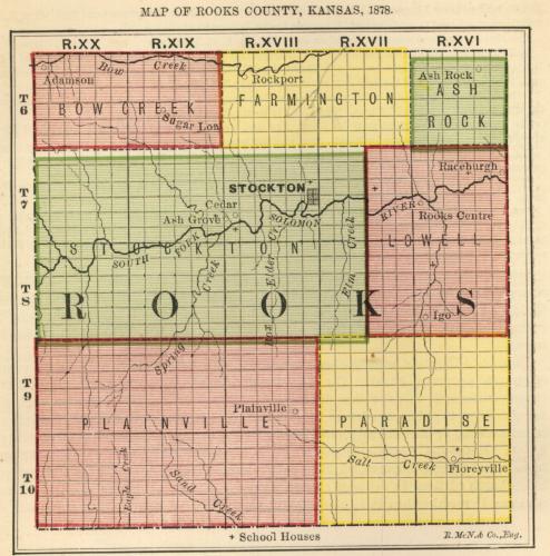
Rooks County was established with four townships: Bow Creek, Lowell, Paradise and Stockton. That number increased to seven by 1878[2] and twenty three in 1925. The twenty three townships were in place until 1971 when the number was reduced to the current twelve townships.[3]
Township 2 was formed from Rooks County townships Greenfield, Iowa and Lanark[4] in 1971 pursuant to Kansas Statute 80-1110.[5] 80-1110 allowed for the disorganization of townships and assigning those territories to contiguous townships.[6]
Elm Creek flows through the southern part of Township 2 into South Fork Solomon River. Jim Creek and Douglas Creek flow through the northern part of Township 2 into South Fork Solomon River.
Greenfield Township
Greenfield Township was created from parts of Lowell and Stockton townships in 1879. The east half from Lowell, the west half from Stockton.[7]
Iowa Township
Iowa Township was created from parts of Lowell and Stockton townships in 1879. The east half from Lowell, the west half from Stockton.[8]
Lanark Township
Lanark Township was created from part of Farmington Township in 1879. Farmington had been created a year earlier from Bow Creek and Lowell townships. Lanark was named for Lanarkshire, Scotland, the birthplace of an early settler in the territory.[9]
References
- "US Board on Geographic Names". United States Geological Survey. 1978-10-13. Retrieved 2018-01-07.
- "MAP OF ROOKS COUNTY, KANSAS, 1878". KS Gen Web. Retrieved February 10, 2018.
- "Rooks County Kansas". Kansas Historical Society. Retrieved February 10, 2018.
- "Kansas Civil Townships and Independent Cities". Kansas Historical Society. Retrieved 2018-01-07.
- BOARD OF COUNTY COMMISSIONERS, ROOKS COUNTY KANSAS (January 7, 1971). "LEGAL ADVERTISING". Plainville Times. p. 10.
- "Chapter 80.:-TOWNSHIPS AND TOWNSHIP OFFICERS". Kansas Office of Revisor of Statutes. Retrieved February 10, 2018.
- Brown, Carl; Wells, L. W. (September 28, 1961). "A History of Greenfield Township". Plainville Times. p. 13.
- Casad, Mrs. Bassell (February 9, 1961). "A History of Iowa Township". Plainville Times. p. 8.
- Bartlett, Mabel (February 16, 1961). "A History of Lanark Township". Plainville Times. p. 5.
Municipalities and communities of Rooks County, Kansas, United States | ||
|---|---|---|
County seat: Stockton | ||
| Cities | 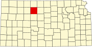 | |
| Unincorporated community | ||
| Ghost towns | ||
| Townships | ||
| Footnotes | †This community is designated a Census-Designated Place (CDP) by the United States Census Bureau. | |
| ||
Другой контент может иметь иную лицензию. Перед использованием материалов сайта WikiSort.org внимательно изучите правила лицензирования конкретных элементов наполнения сайта.
WikiSort.org - проект по пересортировке и дополнению контента Википедии