world.wikisort.org - USA
Summit County is a county in the U.S. state of Utah, occupying a rugged and mountainous area. As of the 2010 United States Census, the population was 36,324.[1] Its county seat is Coalville,[2] and the largest city is Park City.
Summit County | |
|---|---|
U.S. county | |
 Summit County Courthouse in Coalville | |
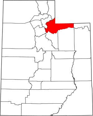 Location within the U.S. state of Utah | |
 Utah's location within the U.S. | |
| Coordinates: 40.88°N 110.97°W | |
| Country | |
| State | |
| Founded | 1854 (created) 1861 (organized) |
| Named for | The summits of the mountains |
| Seat | Coalville |
| Largest city | Park City |
| Area | |
| • Total | 1,882 sq mi (4,870 km2) |
| • Land | 1,872 sq mi (4,850 km2) |
| • Water | 10 sq mi (30 km2) 0.5% |
| Population (2020) | |
| • Total | 42,357 |
| • Density | 23/sq mi (8.7/km2) |
| Time zone | UTC−7 (Mountain) |
| • Summer (DST) | UTC−6 (MDT) |
| Congressional district | 1st |
| Website | www |
History
The county was created by the Utah Territory legislature on January 13, 1854, with its description containing a portion of the future state of Wyoming. It was not organized then but was attached to Great Salt Lake County for administrative and judicial purposes. The county government was completed by March 4, 1861, so its attachment to the other county was terminated. The county boundaries were altered in 1856 and in 1862. In 1868 the Wyoming Territory was created by the US government, effectively de-annexing all Summit County areas falling within the new territory. The boundaries were further altered in 1872 and 1880. Its final alteration occurred on January 7, 1918, when Daggett's creation took a portion of its eastern territory. Its boundary has remained unchanged since that creation.[3] It is so named because it includes 39 of the highest mountain peaks in Utah.
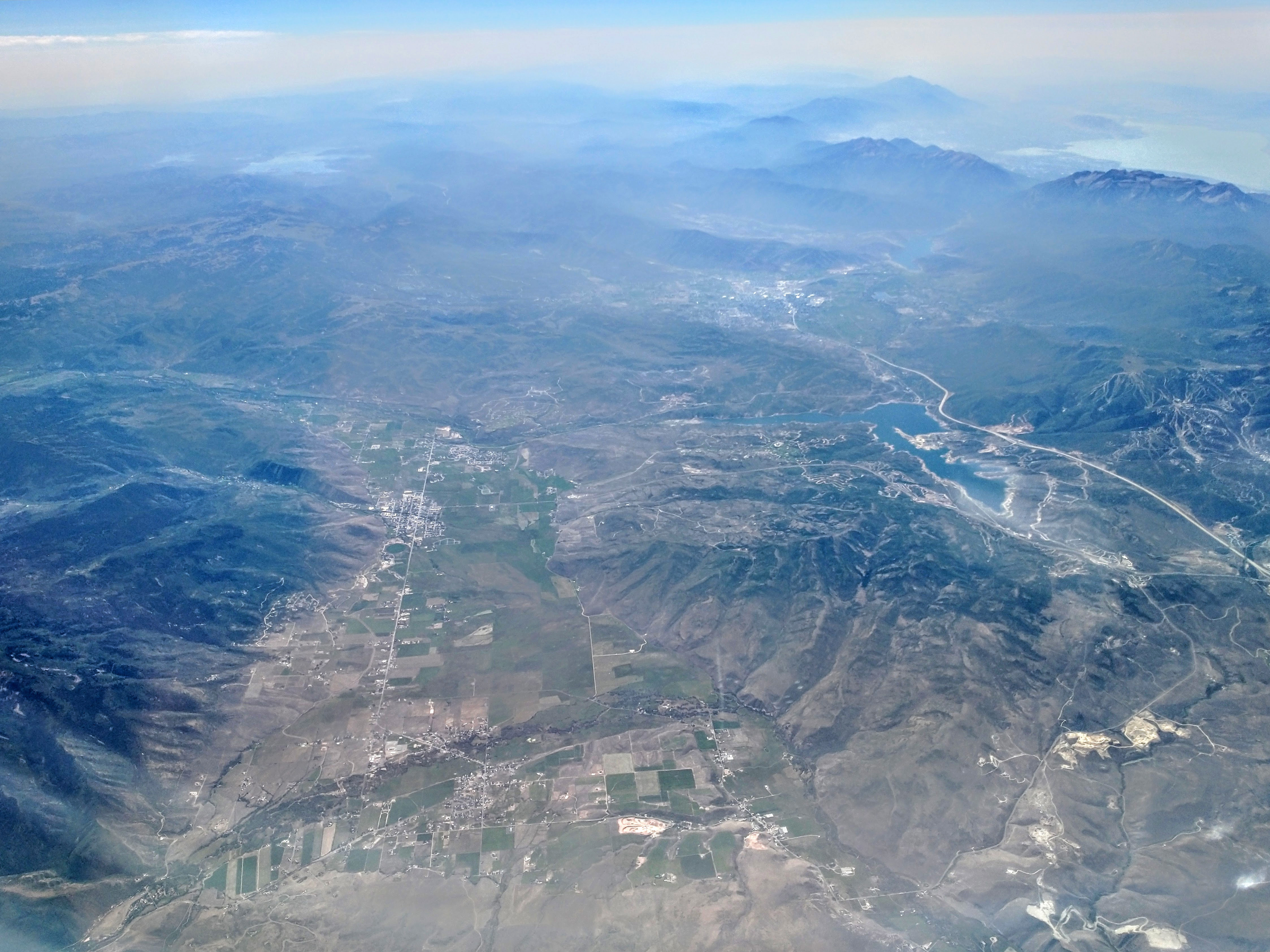
The county's mean elevation is 8,388 feet (2,557 m) above sea level, which is the second-highest (after Taos County, New Mexico) of any county outside Colorado.[4] Owing to its proximity to Salt Lake City, Park City has acquired a reputation as an upscale getaway, bringing new development to the area.
Summit County is part of the Heber, UT Micropolitan Statistical Area, which is also included in the Salt Lake City-Provo-Orem, UT Combined Statistical Area.
Geography
Summit County lies on the upper east side of Utah. Its northeast borders abut the south and west borders of the state of Wyoming. Its central and eastern portion consists largely of the east-west oriented Uinta Mountains, while its western portion runs to the east slopes of the north-south oriented Wasatch Mountains.[5] The county's highest point is Gilbert Peak, on the border with Duchesne County, at 13,448' (4099m) ASL.[6] The county has a total area of 1,882 square miles (4,870 km2), of which 1,872 square miles (4,850 km2) is land and 10 square miles (26 km2) (0.5%) is water.[7]
Major highways[5]
- Interstate 80
- Interstate 84
- U.S. Route 40
- U.S. Route 189
- Utah State Route 32
- Utah State Route 150
- Utah State Route 224
- Utah State Route 248
Adjacent counties
- Rich County - north
- Uinta County, Wyoming - northeast
- Sweetwater County, Wyoming - northeast
- Daggett County - east
- Duchesne County - southeast
- Wasatch County - south
- Salt Lake County - southwest
- Morgan County - northwest
- Salt Lake County - west
Protected areas[5]
- Ashley National Forest (part)
- Henefer-Echo Wildlife Management Area
- Rockport State Park
- Wasatch National Forest (part)
Lakes[5]
- Abes Lake
- Adax Lake
- Alexander Lake
- Alligator Lake
- Allsop Lake
- Amethyst Lake
- Anchor Lake
- Azure Lake
- Baker Lake
- Bald Lake
- Ball and Moore Reservoir
- Barker Reservoir
- Bear Lake
- Beaver Lake (near Coffin Lake)
- Beaver Lake (near Duck Lake)
- Beaver Lake (near Whitney Reservoir)
- Beaver Meadow Reservoir
- Bench Lake
- Bennion Lake
- Beth Lake
- Big Elk Lake
- Blue Lake (near Boyer Lake)
- Blue Lake (near Haystack Lake)
- Bobs Lake
- Bourbon Lake
- Boyer Lake
- Bridger Lake
- Buckeye Lake
- Burnt Fork Lake
- Castle Lake (near Lake Blanchard)
- Castle Lake (near Shingle Creek Lakes)
- Chappell Lake
- China Lake
- Clegg Lake
- Cliff Lake (near Lake Blanchard)
- Cliff Lake (near Trial Lake)
- Clyde Lake
- Coffin Lake
- Crystal Lake
- Cuberant Lake
- Cutthroat Lake (near Island Lake)
- Cutthroat Lake (near Teal Lake)
- Dead Horse Lake
- Dean Lake
- Diamond Lake
- Dine Lake
- Dollar Lake
- Duck Lake (near Bald Lake)
- Duck Lake (near Fire Lake)
- East Red Castle Lake
- Echo Reservoir
- Elizabeth Lake
- Elkhorn Reservoir
- Erickson Lakes
- North Erickson Lake
- South Erickson Lake
- Fir Lake
- Fire Lake
- Fish Lake (near Burnt Fork Lake)
- Fish Lake (near Lyman Lake)
- Fish Lake (near Sand Lake)
- Gendy Lake
- Gilbert Lake
- Grahams Reservoir (part)
- Grass Lake
- Grassy Lakes
- Hayden Lake
- Haystack Lake
- Hell Hole Lake
- Henrys Fork Lake
- Hidden Lake (near Dine Lake)
- Hidden Lake (near Peter Lake)
- Hidden Lake (near Pot Reservoir)
- Hidden Lake (near Spirit Lake)
- Hidden Lake (near Tamarack Lake)
- Hidden Lake (near Smith and Morehouse Reservoir)
- Hoop Lake
- Hope Lake
- Hourglass Lake
- Ibantik Lake
- Island Lake (near Bennion Lake)
- Island Lake (near Grass Lake)
- Island Lake (near Ramona Lake)
- James Lake
- Jean Lake
- Jerry Lake
- Jessen Lake
- Jewel Lake
- John Lake
- Joyce Lake
- Kabell Lakes
- Kamas Lake
- Kermsuh Lake
- Lake Blanchard
- Lake Ejod
- Lake Hessie
- Lake Lorena
- Lake Marion
- Liberty Lake
- Lilly Lake
- Lily Lake
- Lily Lakes (aka Montgomery Lakes)
- Lily Pad Lake
- Linear Lake
- Little Elk Lake
- Little Lyman Lake
- Lofty Lake
- Long Lake
- Lost Lake (near Lilly Lake)
- Lost Lake (near Tamarack Lake)
- Lovenia Lake
- Lower Red Castle Lake
- Lower Yellow Pine Lake
- Lym Lake
- Lyman Lake
- Marjorie Lake
- Marsh Lake
- McPheters Lake
- Meadow Lake
- Meeks Cabin Reservoir (part)
- Moslander Reservoir
- Naomi Lake
- Norice Lake
- Notch Lake (Cliff Lake)
- Olsen Lake
- Ostler Lake
- Peter Lake
- Petit Lake
- Picturesque Lake
- Ponds Lake
- Porcupine Reservoir
- Pot Reservoir
- Priord Lake
- Quarter Corner Lake
- Ramona Lake
- Red Castle Lake
- Red Pine Lake
- Reids Lake
- Rhoads Lake
- Rock Lake
- Rockport Reservoir
- Round Lake
- Ruth Lake
- Ryder Lake
- Salamander Lake
- Salt Fish Lake
- Sand Lake
- Sargent Lake
- Sargent Lakes
- Sargent Number One Reservoir
- Sawmill Lake
- Scow Lake
- Shadow Lake (near Park City)
- Shadow Lake (near Tail Lake)
- Shallow Lake
- Shingle Creek Lakes
- East Shingle Creek Lake
- Lower Shingle Creek Lake
- West Shingle Creek Lake
- Shingle Mill Lake
- Shoestring Lake
- Smith and Morehouse Reservoir
- Smiths Fork Pass Lake
- Spectacle Lake
- Spirit Lake (part)
- Star Lake
- Stateline Reservoir
- Tail Lake
- Tamarack Lake
- Teal Lake
- Teapot Lake (aka Lost Lake Number 2)
- Three Divide Lakes
- Booker Lake
- Divide Lake 1
- Divide Lake 2
- Toomset Lake
- Trial Lake
- Trident Lake
- Twin Lakes
- North Twin Lake
- South Twin Lake
- Upper Red Castle Lake
- Upper Yellow Pine Lake
- Wall Lake
- Washington Lake
- Watson Lake
- Weir Reservoir
- Whiskey Island Lake
- White Pine Lake
- Whitney Reservoir
Demographics
| Historical population | |||
|---|---|---|---|
| Census | Pop. | %± | |
| 1860 | 198 | — | |
| 1870 | 2,512 | 1,168.7% | |
| 1880 | 4,921 | 95.9% | |
| 1890 | 7,733 | 57.1% | |
| 1900 | 9,439 | 22.1% | |
| 1910 | 8,200 | −13.1% | |
| 1920 | 7,862 | −4.1% | |
| 1930 | 9,527 | 21.2% | |
| 1940 | 8,714 | −8.5% | |
| 1950 | 6,745 | −22.6% | |
| 1960 | 5,673 | −15.9% | |
| 1970 | 5,879 | 3.6% | |
| 1980 | 10,198 | 73.5% | |
| 1990 | 15,518 | 52.2% | |
| 2000 | 29,736 | 91.6% | |
| 2010 | 36,324 | 22.2% | |
| 2020 | 42,357 | 16.6% | |
| US Decennial Census[8] 1790–1960[9] 1900–1990[10] 1990–2000[11] 2010–2018[1] 2019[12] 2020[13] | |||
2000 census
As of the 2000 United States Census, there were 29,736 people, 10,332 households, and 7,501 families in the county. The population density was 15.9/sqmi (6.13/km2). There were 17,489 housing units at an average density of 9.34/sqmi (3.61/km2). The racial makeup of the county was 91.80% White, 0.24% Black or African American, 0.31% Native American, 0.96% Asian, 0.04% Pacific Islander, 5.43% from other races, and 1.21% from two or more races. 8.09% of the population were Hispanic or Latino of any race.
There were 10,332 households, of which 40.80% had children under 18 living with them, 63.50% were married couples living together, 6.20% had a female householder with no husband present, and 27.40% were non-families. 18.40% of all households were made up of individuals, and 3.20% had someone living alone who was 65 years of age or older. The average household size was 2.87, and the average family size was 3.30.
The median income for a household in the county was $64,962, and the median income for a family was $72,510. Males had a median income of $47,236 versus $28,621 for females. The per capita income for the county was $33,767. Only 42.9% are natives of Utah. 5.40% of the population and 3.00% of families were below the poverty line.
According to a 2000 survey by the Association of Statisticians of American Religious Bodies, Summit County is much more diverse in religious belief than Utah. Fully two in five people (44.2%) of the population claim no religion at all, while among those that do, The Church of Jesus Christ of Latter-day Saints (LDS Church) is the largest group at 36.8% (compared with some 66% statewide), followed by Roman Catholics at 10.6%.
Politics and government
Summit County has traditionally been a Republican stronghold. Since the 1990s, it has become more competitive due to the influence of Democrat-leaning Park City Since then; Democrats have at times won a plurality or even a majority of the countywide votes. In 1996, Bill Clinton became the first Democrat to win the county since Lyndon Johnson's 44-state landslide in 1964 and only the second Democrat to carry it since Franklin D. Roosevelt. Although George W. Bush carried the county in 2000 and 2004, his performance there was worst in the state. In a 2006 US Senate race, Summit County was the only county carried by Democrat Pete Ashdown even as the Republican incumbent Orrin Hatch carried the state as a whole by a 2 to 1 margin. Likewise, in the 2008 U.S. presidential election, Barack Obama carried the county by a 15.3% margin over John McCain, while McCain carried Utah by 28.1% over Obama.[14] However, in the 2012 presidential election, Republican Mitt Romney defeated Obama in the county, 51% to 46%.[15] In 2016, Democrat Hillary Clinton defeated Republican Donald Trump, 50% to 35%.[14] The county is no more Republican in gubernatorial politics. In both the 2012 and 2016 elections it was the only county to support the Democratic candidate over Gary Herbert.
| Position | District | Name | Affiliation | First Elected | |
|---|---|---|---|---|---|
| Senate | 19 | John D. Johnson | Republican | 2020[16] | |
| Senate | 26 | Ronald Winterton | Republican | 2018[17] | |
| House of Representatives | 28 | Brian King | Democrat | 2008[18] | |
| House of Representatives | 53 | Kera Birkeland | Republican | 2020[19] | |
| House of Representatives | 54 | Mike Kohler | Republican | 2020[20] | |
| Board of Education | 7 | Carol Lear | Democrat | 2016[21] | |
| Board of Education | 12 | James Moss Jr. | Republican | 2020[22] | |
| Year | Republican | Democratic | Third party | |||
|---|---|---|---|---|---|---|
| No. | % | No. | % | No. | % | |
| 2020 | 10,252 | 39.00% | 15,244 | 57.99% | 793 | 3.02% |
| 2016 | 7,333 | 35.11% | 10,503 | 50.29% | 3,049 | 14.60% |
| 2012 | 8,884 | 50.49% | 8,072 | 45.87% | 641 | 3.64% |
| 2008 | 6,956 | 41.11% | 9,532 | 56.34% | 432 | 2.55% |
| 2004 | 7,936 | 51.83% | 6,977 | 45.57% | 399 | 2.61% |
| 2000 | 6,168 | 50.89% | 4,601 | 37.96% | 1,352 | 11.15% |
| 1996 | 3,867 | 41.50% | 4,177 | 44.82% | 1,275 | 13.68% |
| 1992 | 3,133 | 33.33% | 3,013 | 32.06% | 3,253 | 34.61% |
| 1988 | 3,881 | 59.68% | 2,536 | 39.00% | 86 | 1.32% |
| 1984 | 4,093 | 71.79% | 1,539 | 27.00% | 69 | 1.21% |
| 1980 | 3,330 | 65.38% | 1,184 | 23.25% | 579 | 11.37% |
| 1976 | 2,316 | 61.55% | 1,282 | 34.07% | 165 | 4.38% |
| 1972 | 2,209 | 69.95% | 836 | 26.47% | 113 | 3.58% |
| 1968 | 1,782 | 62.37% | 961 | 33.64% | 114 | 3.99% |
| 1964 | 1,335 | 47.14% | 1,497 | 52.86% | 0 | 0.00% |
| 1960 | 1,607 | 56.91% | 1,217 | 43.09% | 0 | 0.00% |
| 1956 | 2,031 | 69.77% | 880 | 30.23% | 0 | 0.00% |
| 1952 | 1,955 | 60.75% | 1,263 | 39.25% | 0 | 0.00% |
| 1948 | 1,617 | 50.44% | 1,556 | 48.53% | 33 | 1.03% |
| 1944 | 1,479 | 45.62% | 1,761 | 54.32% | 2 | 0.06% |
| 1940 | 1,730 | 43.82% | 2,215 | 56.10% | 3 | 0.08% |
| 1936 | 1,422 | 37.58% | 2,344 | 61.95% | 18 | 0.48% |
| 1932 | 1,434 | 40.55% | 2,028 | 57.35% | 74 | 2.09% |
| 1928 | 1,748 | 57.65% | 1,260 | 41.56% | 24 | 0.79% |
| 1924 | 1,597 | 57.16% | 825 | 29.53% | 372 | 13.31% |
| 1920 | 1,503 | 59.79% | 874 | 34.77% | 137 | 5.45% |
| 1916 | 1,195 | 40.69% | 1,495 | 50.90% | 247 | 8.41% |
| 1912 | 1,290 | 44.06% | 983 | 33.57% | 655 | 22.37% |
| 1908 | 1,614 | 50.87% | 1,402 | 44.19% | 157 | 4.95% |
| 1904 | 2,232 | 57.87% | 1,358 | 35.21% | 267 | 6.92% |
| 1900 | 1,555 | 46.64% | 1,763 | 52.88% | 16 | 0.48% |
| 1896 | 245 | 6.72% | 3,402 | 93.28% | 0 | 0.00% |
In the 2016 Senate race, Summit County was the only county in Utah where a plurality voted for Democratic nominee Misty Snow against Republican incumbent Mike Lee. Snow was the first major-party transgender Senate candidate in United States history, making the county the first in the nation to vote for a transgender candidate for the Senate.
On the county level, most of the elected offices are held by Democrats, including four of the five seats on the newly created Summit County Council.[24] -John Hanrahan, D; Claudia McMullin, D; Sally Elliott, D; Chris Robinson, D; David Ure, R
Summit County was one of only two counties (along with Grand County) to vote against Utah's same-sex marriage ban in 2004. In June 2010, Summit County became the sixth local government of Utah to prohibit discrimination in employment or housing based on a person's sexual orientation or gender identity.[25]
Communities
Cities
Towns
Census-designated places
Unincorporated communities
- Alpine Acres
- Bountiful Peak Summer Home Area
- Castle Rock
- Christmas Meadows Summer Home Area
- Emory
- Grass Creek
- Holiday Park
- Monviso
- Rockport
- Uintalands
- Upton
- Weber Canyon
Former communities
- Atkinson
- Blacks Fork
- Mill City
- Wahsatch
Education
There are three school districts covering sections of the county:[26]
- North Summit School District
- Park City School District
- South Summit School District
See also
- List of counties in Utah
- National Register of Historic Places listings in Summit County, Utah
- Utah Transfer of Public Lands Act
References
- "State & County QuickFacts". United States Census Bureau. Retrieved December 29, 2013.
- "Find a County". National Association of Counties. Archived from the original on May 31, 2011. Retrieved June 7, 2011.
- "Utah: Individual County Chronologies". Utah Atlas of Historical County Boundaries. Newberry Library. 2008. Archived from the original on March 6, 2016. Retrieved June 26, 2015.
- Mean County Elevation Lists
- Summit County UT Google Maps (accessed 26 March 2019)
- Utah Counties Highest Elevations (accessed 26 March 2019). Note that this source lists Gilbert Peak elevation as 13,442, not 13,448.
- "2010 Census Gazetteer Files". US Census Bureau. August 22, 2012. Retrieved June 25, 2015.
- "US Decennial Census". US Census Bureau. Archived from the original on April 26, 2015. Retrieved June 25, 2015.
- "Historical Census Browser". University of Virginia Library. Retrieved June 25, 2015.
- Forstall, Richard L., ed. (June 25, 1995). "Population of Counties by Decennial Census: 1900 to 1990". US Census Bureau. Retrieved March 27, 2015.
- "Census 2000 PHC-T-4. Ranking Tables for Counties: 1990 and 2000" (PDF). US Census Bureau. April 2, 2001. Retrieved June 25, 2015.
- "QuickFacts. Utah counties". Retrieved May 17, 2020.
- 2020 Population and Housing State Data | Utah
- US Election Atlas
- "President - Live Election Results - NYTimes.com". The New York Times. Retrieved March 31, 2018.
- "Senator Johnson Utah Senate". senate.utah.gov. Retrieved November 16, 2021.
- "Senator Winterton Utah Senate". senate.utah.gov. Retrieved November 16, 2021.
- "Rep. King, Brian S." Utah House of Representatives. Retrieved November 17, 2021.
- "Rep. Birekeland, Kera". Utah House of Representatives. Retrieved November 17, 2021.
- "Rep. Kohler, Mike L." Utah House of Representatives. Retrieved November 17, 2021.
- "Carol Lear". www.schools.utah.gov. Retrieved November 16, 2021.
- "James Moss Jr". www.schools.utah.gov. Retrieved November 16, 2021.
- Leip, David. "Atlas of US Presidential Elections". uselectionatlas.org. Retrieved March 31, 2018.
- Summit County Democrats Archived April 6, 2009, at the Wayback Machine
- Winters, Rosemary (June 17, 2010), "Summit County bans anti-gay discrimination", Salt Lake Tribune, archived from the original on October 15, 2011, retrieved June 18, 2010
- "2020 CENSUS - SCHOOL DISTRICT REFERENCE MAP: Summit County, UT" (PDF). U.S. Census Bureau. Retrieved November 2, 2022. - Text list
External links
Places adjacent to Summit County, Utah | |
|---|---|
Municipalities and communities of Summit County, Utah, United States | ||
|---|---|---|
County seat: Coalville | ||
| Cities |  | |
| Towns | ||
| CDPs | ||
| Unincorporated communities | ||
| Ghost towns | ||
| Footnotes | ‡This populated place also has portions in an adjacent county or counties | |
| ||
State of Utah | |||||||||||||
|---|---|---|---|---|---|---|---|---|---|---|---|---|---|
Salt Lake City (capital) | |||||||||||||
| Topics | |||||||||||||
| Society |
| ||||||||||||
| Regions |
| ||||||||||||
| Largest cities |
| ||||||||||||
| Counties | |||||||||||||
| Attractions |
| ||||||||||||
| Flora and fauna | |||||||||||||
На других языках
[de] Summit County (Utah)
Summit County[3] ist ein County im Bundesstaat Utah der Vereinigten Staaten. Der Sitz der Countyverwaltung (County Seat) ist Coalville. Der größte Ort im County ist Park City.- [en] Summit County, Utah
[es] Condado de Summit (Utah)
El condado de Summit (en inglés: Summit County), fundado en 1854, es uno de 29 condados del estado estadounidense de Utah. En el año 2000, el condado tenía una población de 29,736 habitantes y una densidad poblacional de 6 personas por km². La sede del condado es Coalville.[1][ru] Саммит (округ, Юта)
Округ Саммит (англ. Summit County) располагается в штате Юта, США. Официально образован в 1854 году. По состоянию на 2010 год, численность населения составляла 36 324 человек.Другой контент может иметь иную лицензию. Перед использованием материалов сайта WikiSort.org внимательно изучите правила лицензирования конкретных элементов наполнения сайта.
WikiSort.org - проект по пересортировке и дополнению контента Википедии