world.wikisort.org - USA
Stewartsville is an unincorporated community and census-designated place (CDP) located within Greenwich Township in Warren County, New Jersey, United States,[9] that was created as part of the 2010 United States Census.[10][11][12] As of the 2010 Census, the CDP's population was 349.[13]
Stewartsville, New Jersey | |
|---|---|
Census-designated place | |
 Hulshizer/Brill farm on North main street built in 1833 | |
 Stewartsville Location of Stewartsville in Warren County (Inset: Location of Warren County in New Jersey).  Stewartsville Stewartsville (New Jersey)  Stewartsville Stewartsville (the United States) | |
| Coordinates: 40°41′38″N 75°6′41″W[1][2] | |
| Country | |
| State | |
| County | Warren |
| Township | Greenwich |
| Named for | Thomas Stewart |
| Area | |
| • Total | 1.08 sq mi (2.80 km2) |
| • Land | 1.08 sq mi (2.80 km2) |
| • Water | 0.00 sq mi (0.00 km2) 0.00% |
| Elevation | 315 ft (96 m) |
| Population (2020)[4] | |
| • Total | 636 |
| • Density | 587.80/sq mi (226.98/km2) |
| Time zone | UTC-5 (Eastern (EST)) |
| • Summer (DST) | UTC-4 (EDT) |
| ZIP code | 08886[5] |
| Area code | 908 |
| FIPS code | 3470800[6][7][8] |
| GNIS feature ID | 2584031[1] |
The area is served as United States Postal Service ZIP code 08886.[5]
The community of Stewartsville was named after Thomas Stewart, a secretary to George Washington, who purchased property in the area in 1793.[14]
Geography
According to the United States Census Bureau, the CDP had a total area of 0.129 square miles (0.333 km2), all of which was land.[6][2]
Demographics
| Historical population | |||
|---|---|---|---|
| Census | Pop. | %± | |
| 2020 | 636 | — | |
| U.S. Decennial Census[15][4] | |||
Census 2010
The 2010 United States census counted 349 people, 134 households, and 96 families in the CDP. The population density was 2,714.4 per square mile (1,048.0/km2). There were 144 housing units at an average density of 1,120.0 per square mile (432.4/km2). The racial makeup was 93.98% (328) White, 4.58% (16) Black or African American, 0.00% (0) Native American, 0.57% (2) Asian, 0.00% (0) Pacific Islander, 0.00% (0) from other races, and 0.86% (3) from two or more races. Hispanic or Latino of any race were 6.30% (22) of the population.[13]
Of the 134 households, 36.6% had children under the age of 18; 52.2% were married couples living together; 14.2% had a female householder with no husband present and 28.4% were non-families. Of all households, 21.6% were made up of individuals and 8.2% had someone living alone who was 65 years of age or older. The average household size was 2.60 and the average family size was 3.05.[13]
26.4% of the population were under the age of 18, 7.4% from 18 to 24, 26.4% from 25 to 44, 27.8% from 45 to 64, and 12.0% who were 65 years of age or older. The median age was 40.3 years. For every 100 females, the population had 97.2 males. For every 100 females ages 18 and older there were 90.4 males.[13]
Census 2000
As of the 2000 United States Census, the population for ZIP Code Tabulation Area 08886 was 4,854.[16]
Transportation
The area is accessible via exit 4 and exit 3 on Interstate 78.
Stewartsville had a station on the Morris and Essex Railroad, located 80 miles (130 km) from New York City.[17]
Points of interest
The nearby Kennedy House and Mill, located on Route 173 in Kennedy Mills, was listed on the National Register of Historic Places in 1996.[18]
The town features two churches, the First Lutheran Church and the Stewartsville Presbyterian Church.[19]
 First Lutheran
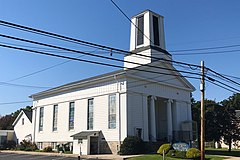 Stewartsville Presbyterian


References
- "Stewartsville Census Designated Place". Geographic Names Information System. United States Geological Survey, United States Department of the Interior.
- US Gazetteer files: 2010, 2000, and 1990, United States Census Bureau. Accessed September 4, 2014.
- "ArcGIS REST Services Directory". United States Census Bureau. Retrieved October 11, 2022.
- "Census Population API". United States Census Bureau. Retrieved October 11, 2022.
- Look Up a ZIP Code for Stewartsville, NJ, United States Postal Service. Accessed June 3, 2013.
- Gazetteer of New Jersey Places, United States Census Bureau. Accessed July 21, 2016.
- U.S. Census website, United States Census Bureau. Accessed September 4, 2014.
- A Cure for the Common Codes: New Jersey, Missouri Census Data Center. Accessed June 3, 2013.
- Locality Search, State of New Jersey. Accessed April 19, 2015.
- GCT-PH1 - Population, Housing Units, Area, and Density: 2010 - County -- County Subdivision and Place from the 2010 Census Summary File 1 for Warren County, New Jersey Archived 2020-02-12 at archive.today, United States Census Bureau. Accessed June 4, 2013.
- 2006-2010 American Community Survey Geography for New Jersey, United States Census Bureau. Accessed June 4, 2013.
- New Jersey: 2010 - Population and Housing Unit Counts - 2010 Census of Population and Housing (CPH-2-32), United States Census Bureau, p. III-5, August 2012. Accessed June 4, 2013. "Warren County—Name Changes: Beattystown CDP name corrected from Beatyestown; New CDPs: Allamuchy (formed from part of deleted Allamuchy-Panther Valley CDP), Anderson, Asbury, Blairstown, Brainards, Bridgeville, Broadway, Brookfield, Buttzville, Columbia, Delaware, Delaware Park, Finesville, Great Meadows (formed from part of deleted Great Meadows-Vienna CDP and additional area), Greenwich, Hainesburg, Harmony, Hope, Hutchinson, Johnsonburg, Lopatcong Overlook, Marksboro, Mountain Lake, Mount Hermon, New Village, Panther Valley (formed from part of deleted Allamuchy-Panther Valley CDP), Port Colden, Port Murray, Silver Lake, Stewartsville, Upper Pohatcong, Upper Stewartsville, and Vienna (formed from part of deleted Great Meadows-Vienna and additional area)"
- DP-1 - Profile of General Population and Housing Characteristics: 2010 Demographic Profile Data for Stewartsville CDP, New Jersey, United States Census Bureau. Accessed June 3, 2013.
- Home Page, Greenwich Township. Accessed February 25, 2013. "Our town was named after Thomas Stewart, a secretary to George Washington. Thomas Stewart purchased 360 acres and began to reside in Greenwich in 1793. The original Stewart home still stands along with many other farm houses and mills."
- "Census of Population and Housing". Census.gov. Retrieved June 4, 2016.
- DP-1 Profile of General Demographic Characteristics: 2000 from the Census 2000 Summary File 1 (SF 1) 100-Percent Data for ZCTA 08886 Archived 2020-02-12 at archive.today, United States Census Bureau. Accessed June 3, 2013.
- Travelers' official Guide of the Railways; June 1, 1870: National Railway Publication Company.
- "National Register Information System – (#96000552)". National Register of Historic Places. National Park Service. November 2, 2013.
- "Churches". Greenwich Township. January 30, 2014.
External links
Municipalities and communities of Warren County, New Jersey, United States | ||
|---|---|---|
County seat: Belvidere | ||
| Boroughs |  | |
| Towns | ||
| Townships | ||
| CDPs |
| |
| Other unincorporated communities | ||
| ||
Authority control | |
|---|---|
| General | |
| National libraries | |
Другой контент может иметь иную лицензию. Перед использованием материалов сайта WikiSort.org внимательно изучите правила лицензирования конкретных элементов наполнения сайта.
WikiSort.org - проект по пересортировке и дополнению контента Википедии