world.wikisort.org - USA
Finesville is an unincorporated community and census-designated place (CDP) located within Pohatcong Township in Warren County, New Jersey, United States,[9] that was defined as part of the 2010 United States Census.[10][11][12] As of the 2010 Census, the CDP's population was 175.[13]
Finesville, New Jersey | |
|---|---|
Census-designated place | |
 Stone houses on Mount Joy Road | |
 Finesville  Finesville  Finesville  Finesville | |
| Coordinates: 40°36′30″N 75°10′16″W[1] | |
| Country | |
| State | |
| County | Warren |
| Township | Pohatcong |
| Named for | Philip and John Fein |
| Area | |
| • Total | 2.19 sq mi (5.68 km2) |
| • Land | 2.12 sq mi (5.48 km2) |
| • Water | 0.08 sq mi (0.20 km2) 0.00% |
| Elevation | 262 ft (80 m) |
| Population (2020)[4] | |
| • Total | 364 |
| • Density | 171.94/sq mi (66.39/km2) |
| Time zone | UTC-5 (Eastern (EST)) |
| • Summer (DST) | UTC-4 (EDT) |
| Area code | 908 |
| FIPS code | 3423340[5][6][7] |
| GNIS feature ID | 876338[1] 2583989[5][8] |
History
The community is located along the Musconetcong River between Pohatcong Mountain and Musconetcong Mountain, about a mile east of the Delaware River in a section of the Musconetcong Valley called the Musconetcong Gorge. The settlement was named for Philip and John Fein (often misspelled Fine by locals) who settled in the area from Germany. They built a dam and ran an oil mill, gristmill, sawmill, hotel and a store.[14]
The area was first built up as a permanent settlement due to the construction of Chelsea Forge, built in 1751,[15] a charcoal-iron forge on the Musconetcong.[16] The forge helped to provide the Continental Army with weapons to defend Valley Forge. The Shank Brothers ran a ferry across the Delaware River from the point where the Musconetcong empties into it prior to 1800.[17] The Fein gristmill burned and was later rebuilt as the Riegel Paper Corporation's paper mill[18] and became the Taylor Stiles and Company knife factory.
Historic district
Finesville–Seigletown Historic District | |
U.S. National Register of Historic Places | |
U.S. Historic district | |
New Jersey Register of Historic Places
| |
 Finesville Hotel on County Route 627 | |
| Location | County Route 627; Mountain, Musconetcong, Mount Joy and Bellis Roads |
|---|---|
| Area | 195 acres (79 ha) |
| Architectural style | Early Republic, Late Victorian, multiple styles |
| NRHP reference No. | 10000892[19] |
| NJRHP No. | 4398[20][21] |
| Significant dates | |
| Added to NRHP | November 10, 2010 |
| Designated NJRHP | March 4, 2010 |
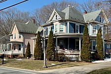
The Finesville–Seigletown Historic District is a 195-acre (79 ha) historic district encompassing the community along County Route 627 (Riegelsville-Warren Glen Road); Mountain, Musconetcong, Mount Joy and Bellis roads, and extending into Holland Township, Hunterdon County. It was added to the National Register of Historic Places on November 10, 2010, for its significance in architecture, industry, engineering, and exploration/settlement. The district includes 97 contributing buildings, 6 contributing structures, and 5 contributing sites.[22]
The district includes the Seigle Homestead, listed individually on the NRHP in 1977 and located in the Seigletown section of community. There are over twenty early stone houses in the community. Many architectural styles are represented, including Colonial Revival, Gothic Revival, Victorian, and Queen Anne.[22]
 Queen Anne and Colonial Revival houses on County Route 627
 Stone house on Mount Joy Road in Holland Township
 Stone house with Victorian embellishment
 House with Gothic Revival influences


Geography
According to the United States Census Bureau, Finesville had a total area of 0.325 square miles (0.841 km2), all of which was land.[5][23]
Demographics
| Historical population | |||
|---|---|---|---|
| Census | Pop. | %± | |
| 2020 | 364 | — | |
| U.S. Decennial Census[24][4] | |||
Census 2010
The 2010 United States census counted 175 people, 72 households, and 49 families in the CDP. The population density was 538.8 per square mile (208.0/km2). There were 87 housing units at an average density of 267.9 per square mile (103.4/km2). The racial makeup was 97.14% (170) White, 0.00% (0) Black or African American, 0.00% (0) Native American, 1.14% (2) Asian, 0.00% (0) Pacific Islander, 0.57% (1) from other races, and 1.14% (2) from two or more races. Hispanic or Latino of any race were 2.86% (5) of the population.[13]
Of the 72 households, 31.9% had children under the age of 18; 59.7% were married couples living together; 5.6% had a female householder with no husband present and 31.9% were non-families. Of all households, 23.6% were made up of individuals and 5.6% had someone living alone who was 65 years of age or older. The average household size was 2.43 and the average family size was 2.88.[13]
22.9% of the population were under the age of 18, 4.0% from 18 to 24, 25.1% from 25 to 44, 38.3% from 45 to 64, and 9.7% who were 65 years of age or older. The median age was 43.5 years. For every 100 females, the population had 110.8 males. For every 100 females ages 18 and older there were 110.9 males.[13]
Places of worship
The Finesville Church was built in 1877.[25][26] The Finesville United Methodist Church was built in 1879 and displays Greek Revival influences.[27] Both are contributing properties of the historic district.[22]
 Finesville Church
 Finesville United Methodist Church


Transportation

The Mount Joy Road Bridge crosses the Musconetcong River and connects Pohatcong and Holland Townships. This Pratt truss bridge, a contributing structure of the historic district, was built c. 1890 and is the only known example made by G. M. Russling of Hackettstown.[22] County Route 627 (Riegelsville-Warren Glen Road) runs northeast-southwest through the community and intersects with Mountain and Mount Joy Roads.[28]
Points of interest
- Hunts Meadow – named for patriot Edward Hunt who dug the millrace here and wintered sixty cavalry horses for the Continental Army in 1778.[29]
- Seigletown – named for Benjamin Seigle, a Revolutionary militia captain, who lived here and made red clay pottery called Seigleware. The family owned a farm, a gristmill, clovermill, blacksmith shop and hematite mine.
Wineries
- Alba Vineyard
- Villa Milagro Vineyards
See also
- National Register of Historic Places listings in Warren County, New Jersey
References
- "Finesville". Geographic Names Information System. United States Geological Survey, United States Department of the Interior.
- "ArcGIS REST Services Directory". United States Census Bureau. Retrieved October 11, 2022.
- U.S. Geological Survey Geographic Names Information System: Finesville Census Designated Place, Geographic Names Information System. Accessed June 3, 2013
- "Census Population API". United States Census Bureau. Retrieved October 11, 2022.
- Gazetteer of New Jersey Places, United States Census Bureau. Accessed July 21, 2016.
- U.S. Census website, United States Census Bureau. Accessed September 4, 2014.
- A Cure for the Common Codes: New Jersey, Missouri Census Data Center. Accessed June 3, 2013.
- US Board on Geographic Names, United States Geological Survey. Accessed September 4, 2014.
- Locality Search, State of New Jersey. Accessed April 18, 2015.
- GCT-PH1 – Population, Housing Units, Area, and Density: 2010 – County – County Subdivision and Place from the 2010 Census Summary File 1 for Warren County, New Jersey Archived February 12, 2020, at archive.today, United States Census Bureau. Accessed June 4, 2013.
- 2006–2010 American Community Survey Geography for New Jersey, United States Census Bureau. Accessed June 4, 2013.
- New Jersey: 2010 – Population and Housing Unit Counts – 2010 Census of Population and Housing (CPH-2-32), United States Census Bureau, p. III-5, August 2012. Accessed June 4, 2013. "Warren County—Name Changes: Beattystown CDP name corrected from Beatyestown; New CDPs: Allamuchy (formed from part of deleted Allamuchy-Panther Valley CDP), Anderson, Asbury, Blairstown, Brainards, Bridgeville, Broadway, Brookfield, Buttzville, Columbia, Delaware, Delaware Park, Finesville, Great Meadows (formed from part of deleted Great Meadows-Vienna CDP and additional area), Greenwich, Hainesburg, Harmony, Hope, Hutchinson, Johnsonburg, Lopatcong Overlook, Marksboro, Mountain Lake, Mount Hermon, New Village, Panther Valley (formed from part of deleted Allamuchy-Panther Valley CDP), Port Colden, Port Murray, Silver Lake, Stewartsville, Upper Pohatcong, Upper Stewartsville, and Vienna (formed from part of deleted Great Meadows-Vienna and additional area)"
- DP-1 – Profile of General Population and Housing Characteristics: 2010 Demographic Profile Data for Finesville CDP, New Jersey Archived February 12, 2020, at archive.today, United States Census Bureau. Accessed June 3, 2013.
- Dale, Frank. "Lower Musconetcong Valley; A Drive in the Country", Skylands Visitor. Accessed July 10, 2015.
- Wacker, Peter O. The Musconetcong Valley of New Jersey: A Historical Geography, p. 152. New Brunswick, Rutgers University Press, 1968. Accessed July 10, 2015.
- Finesvile Marker
- Musconetcong River
- Cummins, George Wyckoff. "History of Pohatcong, NJ", from 'History of Warren County, NJ, Lewis Historical Publishing Company, 1911. Accessed July 10, 2015.
- "National Register Information System – (#10000892)". National Register of Historic Places. National Park Service. November 2, 2013.
- "New Jersey and National Registers of Historic Places - Warren County" (PDF). New Jersey Department of Environmental Protection - Historic Preservation Office. September 28, 2021. p. 10.
- "New Jersey and National Registers of Historic Places - Hunterdon County" (PDF). New Jersey Department of Environmental Protection - Historic Preservation Office. September 28, 2021. p. 8.
- Bertland, Dennis; Armstrong, Janice (July 2009). "National Register of Historic Places Inventory/Nomination: Finesville–Seigletown Historic District". National Park Service – via National Archives Catalog for New Jersey.
{{cite web}}: External link in|via= - US Gazetteer files: 2010, 2000, and 1990, United States Census Bureau. Accessed September 4, 2014.
- "Census of Population and Housing". Census.gov. Retrieved June 4, 2016.
- Greenagel, Frank L. "Finesville Christian Church". The New Jersey Churchscape. Rutgers University Press. ISBN 9-780-8135-2990-5.
- "Finesville Church". Finesville Church.
- Greenagel, Frank L. "Finesville Methodist Episcopal Church". The New Jersey Churchscape. Rutgers University Press. ISBN 9-780-8135-2990-5.
- "Warren County Route 627 straight line diagram" (PDF). New Jersey Department of Transportation. p. 1.
- Finesville Historical Markers
External links
 Media related to Finesville, New Jersey at Wikimedia Commons
Municipalities and communities of Warren County, New Jersey, United States | ||
|---|---|---|
County seat: Belvidere | ||
| Boroughs |  | |
| Towns | ||
| Townships | ||
| CDPs |
| |
| Other unincorporated communities | ||
| ||
National Register of Historic Places in Warren County, New Jersey | ||
|---|---|---|
| Districts |
| |
| Places of worship |
| |
| Houses |
| |
| Buildings |
| |
| Sites |
| |
| Structures |
| |
See also: National Register of Historic Places listings in Warren County, New Jersey and List of National Historic Landmarks in New Jersey | ||
Другой контент может иметь иную лицензию. Перед использованием материалов сайта WikiSort.org внимательно изучите правила лицензирования конкретных элементов наполнения сайта.
WikiSort.org - проект по пересортировке и дополнению контента Википедии