world.wikisort.org - USA
Staten Island Community Board 2 is a local government unit of the city of New York, encompassing the Staten Island neighborhoods of Arrochar, Bloomfield, Bulls Head, Chelsea, southern Castleton Corners, Dongan Hills, Egbertville, Emerson Hill, southern Graniteville, Grant City, Grasmere, Heartland Village, Midland Beach, New Dorp, New Springville, Oakwood, Ocean Breeze, Old Town, South Beach, Todt Hill, Travis, and southern Willowbrook.[4]
Staten Island Community District 2
Staten Island Community Board 2 Mid-Island | |
|---|---|
Community District | |
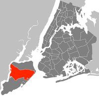 Location in Staten Island | |
| Country | |
| State | |
| City | |
| Borough | |
| Neighborhoods | list
|
| Government | |
| • Type | Community board |
| • Body | Staten Island Community Board 2 |
| • Chairperson | Robert J. Collegio |
| • District Manager | Debra Derrico |
| Area | |
| • Total | 21.3 sq mi (55 km2) |
| Population (2010) | |
| • Total | 132,003 |
| • Density | 6,200/sq mi (2,400/km2) |
| Ethnicity | |
| • Hispanic and Latino Americans | 13.9% |
| • African-American | 4.1% |
| • White | 66.1% |
| • Asian | 13.8% |
| • Others | 2.1% |
| Time zone | UTC−5 (Eastern) |
| • Summer (DST) | UTC−4 (EDT) |
| ZIP codes | 10301, 10304, 10305, 10306, and 10314 |
| Area codes | 718, 347, and 929, and 917 |
| Police Precincts | |
| Website | www |
| [1][2][3] | |
Its current chairman is Robert J. Collegio, and its district manager Debra Derrico.[3]
References
- "NYC Community District Profiles". communityprofiles.planning.nyc.gov. Retrieved October 16, 2021.
- "si02_profile.pdf" (PDF). docs.google.com. Retrieved October 16, 2021.
- "Staten Island Boards". Retrieved October 16, 2021.
- Community Boards, Mayor's Community Affairs Unit (CAU), New York City. Archived 2008-07-06 at the Wayback Machine
Uniform Land Use Review Procedure of New York City | ||||||||
|---|---|---|---|---|---|---|---|---|
|  | |||||||
Neighborhoods in the New York City borough of Staten Island | ||
|---|---|---|
| North Shore (Community District 1) |
|  |
| Mid-Island (Community District 2) |
| |
| South Shore (Community District 3) |
| |
| Related areas |
| |
This New York City–related article is a stub. You can help Wikipedia by expanding it. |
Текст в блоке "Читать" взят с сайта "Википедия" и доступен по лицензии Creative Commons Attribution-ShareAlike; в отдельных случаях могут действовать дополнительные условия.
Другой контент может иметь иную лицензию. Перед использованием материалов сайта WikiSort.org внимательно изучите правила лицензирования конкретных элементов наполнения сайта.
Другой контент может иметь иную лицензию. Перед использованием материалов сайта WikiSort.org внимательно изучите правила лицензирования конкретных элементов наполнения сайта.
2019-2026
WikiSort.org - проект по пересортировке и дополнению контента Википедии
WikiSort.org - проект по пересортировке и дополнению контента Википедии