world.wikisort.org - USA
Bronx Community Board 10 is a local government unit of the New York City borough of the Bronx, encompassing the neighborhoods of City Island, Co-op City, Pelham Bay, Throggs Neck and Westchester Square. It is delimited by the Hutchinson River and Pelham Bay Park to the east, New England Thruway, Hutchinson River Parkway, and Westchester Creek to the west, the Bronx/Westchester County Line to the north and the East River to the south.
Bronx Community District 10
Bronx Community Board 10 | |
|---|---|
Community District | |
 | |
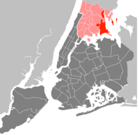 Location in The Bronx | |
| Country | |
| State | |
| City | |
| Borough | |
| Neighborhoods | list
|
| Government | |
| • Type | Community board |
| • Body | Bronx Community Board 10 |
| • Chairperson | Joseph Russo |
| • District Manager | Matthew Cruz |
| Area | |
| • Total | 6.7 sq mi (17 km2) |
| Population (2000) | |
| • Total | 115,948 |
| • Density | 17,000/sq mi (6,700/km2) |
| Ethnicity | |
| • Hispanic and Latino Americans | 36.2% |
| • African-American | 27.2% |
| • White | 48.9% |
| • Asian | 3% |
| • Others | 0.5% |
| • American Indian or Alaska Native | 0.1% |
| Time zone | UTC−5 (Eastern) |
| • Summer (DST) | UTC−4 (EDT) |
| ZIP codes | 10461, 10465, 10467, and 10475 |
| Area codes | 718, 347, and 929, and 917 |
| Police Precincts | 45th (website) |
| Website | www1 |
| [1] [2] | |
Community board staff and membership
The current chairperson of the Bronx Community Board 10 is Joseph Russo. Its District Manager is Matthew Cruz. Cruz is the 4th District Manager in the Board's history and the first of Latino descent.
The City Council members representing the community district are non-voting, ex officio board members.[3] The council members and their council districts are:[4]
- 12th NYC Council District - Kevin Riley (politician)
- 13th NYC Council District - Marjorie Velazquez
- 18th NYC Council District - Amanda Farias
Demographics
As of the United States 2000 Census, the Community Board has a population of 115,948, up from 108,093 in 1990 and 106,516 in 1980. Of them, 22,754 (19.6%) are Black, 56,063 (48.4%) are White, non-Hispanic, 3,462 (3%) are Asian or Pacific Islander, 164 (0.1%) American Indian or Alaska Native, 525 (0.5%) are some other race, and 2,172 (1.9%) of two or more races. 30,808 (26.6%) are of Hispanic origin.
References
- "NYC Planning | Community Profiles". communityprofiles.planning.nyc.gov. Retrieved March 31, 2018.
- "bx10_profile.pdf" (PDF). docs.google.com. NYC Department of Planning. Retrieved March 31, 2018.
- New York City Charter § 2800(a)
- "Bronx Community Board 10 Elected Officials" (PDF). Retrieved 11 April 2018.
External links
Uniform Land Use Review Procedure of New York City | ||||||||
|---|---|---|---|---|---|---|---|---|
|  | |||||||
Neighborhoods in the New York City borough of the Bronx | ||
|---|---|---|
| South Bronx |
|  |
| West Bronx |
| |
| East Bronx |
| |
| Related areas |
| |
This New York City–related article is a stub. You can help Wikipedia by expanding it. |
- "CAU - Find Your Community Board - Bronx Community Boards". www.nyc.gov. Archived from the original on 18 May 2017. Retrieved 31 March 2018.
Другой контент может иметь иную лицензию. Перед использованием материалов сайта WikiSort.org внимательно изучите правила лицензирования конкретных элементов наполнения сайта.
WikiSort.org - проект по пересортировке и дополнению контента Википедии