world.wikisort.org - USA
Spring Valley is a census-designated place (CDP) in the East County region of San Diego County, California. The population was 28,205 at the 2010 census.
Spring Valley | |
|---|---|
census-designated place | |
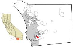 Location in San Diego County and the state of California | |
 Spring Valley Location in the United States | |
| Coordinates: 32°44′4″N 116°58′53″W | |
| Country | |
| State | |
| County | San Diego |
| Area | |
| • Total | 7.374 sq mi (19.099 km2) |
| • Land | 7.165 sq mi (18.558 km2) |
| • Water | 0.209 sq mi (0.541 km2) 2.83% |
| Elevation | 390 ft (119 m) |
| Population (2010) | |
| • Total | 28,205 |
| • Density | 3,800/sq mi (1,500/km2) |
| Time zone | UTC-8 (PST) |
| • Summer (DST) | UTC-7 (PDT) |
| ZIP codes | 91976-91979 |
| Area code | 619 |
| FIPS code | 06-73696 |
| GNIS feature ID | 1661495 |
From 1970 through 1990, Spring Valley included what is now the La Presa CDP to the south; La Presa is still popularly considered to be a part of Spring Valley. Extended definitions of Spring Valley may also include the Casa de Oro neighborhood to the north, which belongs to the Casa de Oro-Mount Helix CDP. Locations in both La Presa and Casa de Oro use Spring Valley addresses.
Spring Valley is served by the 91977 and 91978 ZIP codes.
History
Spring Valley is named for the natural spring located there. It was long the home of the Kumeyaay people, who called it Neti or Meti. Spanish conquerors drove off the natives and used the area for cattle, calling it El aguaje de San Jorge (St. George's Spring).
In 1863 Judge Augustus S. Ensworth of San Diego filed a claim for a 160-acre (65 ha) ranch that included the spring. The ranch, and the small adobe house he built there, were sold to Rufus King Porter and later to historian Hubert Howe Bancroft. The adobe is now a National Historic Landmark.
Geography
The United States Geological Survey (USGS) places Spring Valley at 32°44′41″N 116°59′56″W (32.7447740, -116.9989160).[2] This is near the intersection of Kenwood Drive and Helix Street. Most maps place Spring Valley at this location.
The United States Census Bureau places Spring Valley at 32°44′4″N 116°58′53″W (32.734318, -116.981372),[2] which is approximately two miles southeast of where the USGS places it. According to the United States Census Bureau, the CDP has a total area of 7.4 square miles (19 km2). 7.2 square miles (19 km2) of it is land and 0.2 square miles (0.52 km2) of it (2.83%) is water.
Demographics
| Historical population | |||
|---|---|---|---|
| Census | Pop. | %± | |
| 1970 | 29,742 | — | |
| 1980 | 40,191 | 35.1% | |
| 1990 | 55,331 | 37.7% | |
| 2000 | 26,663 | −51.8% | |
| 2010 | 28,205 | 5.8% | |
| source:[3][4] | |||
2010
At the 2010 census Spring Valley had a population of 28,205. The population density was 3,824.9 inhabitants per square mile (1,476.8/km2). The racial makeup of Spring Valley was 10,915 (38.7%) White, 3,449 (11.1%) African American, 237 (0.8%) Native American, 1,766 (5.7%) Asian, 616 (2.0%) Pacific Islander, 5,172 (17.4%) from other races, and 1,828 (6.5%) from two or more races. Hispanic or Latino of any race were 11,201 persons (36.0%).[5]
The census reported that 28,040 people (99.4% of the population) lived in households, 51 (0.2%) lived in non-institutionalized group quarters, and 114 (0.4%) were institutionalized.
There were 9,305 households, 3,854 (41.4%) had children under the age of 18 living in them, 4,940 (53.1%) were opposite-sex married couples living together, 1,514 (16.3%) had a female householder with no husband present, 636 (6.8%) had a male householder with no wife present. There were 560 (6.0%) unmarried opposite-sex partnerships, and 96 (1.0%) same-sex married couples or partnerships. 1,612 households (17.3%) were one person and 560 (6.0%) had someone living alone who was 65 or older. The average household size was 3.01. There were 7,090 families (76.2% of households); the average family size was 3.39.
The age distribution was 7,481 people (26.5%) under the age of 18, 2,819 people (10.0%) aged 18 to 24, 7,496 people (26.6%) aged 25 to 44, 7,461 people (26.5%) aged 45 to 64, and 2,948 people (10.5%) who were 65 or older. The median age was 35.0 years. For every 100 females, there were 95.2 males. For every 100 females age 18 and over, there were 90.6 males.
There were 9,741 housing units at an average density of 1,321.0 per square mile, of the occupied units 5,916 (63.6%) were owner-occupied and 3,389 (36.4%) were rented. The homeowner vacancy rate was 1.9%; the rental vacancy rate was 4.9%. 17,130 people (60.7% of the population) lived in owner-occupied housing units and 10,910 people (38.7%) lived in rental housing units.
2000
The United States Census Bureau has split Spring Valley (in its greater sense) into two Census-Designated Places (CDPs). The statistics below cover only the Spring Valley CDP. For the demographics of the complete community of Spring Valley also see La Presa, California.
At the 2000 census there were 26,663 people, 9,129 households, and 6,901 families in the CDP. The population density was 3,685.4 inhabitants per square mile (1,423.9/km2). There were 9,291 housing units at an average density of 1,284.2 per square mile (495.8/km2). The racial makeup of the CDP was 45.6% White, 10.7% African American, 0.8% Native American, 4.8% Asian, 1.2% Pacific Islander, 12.4% from other races, and 6.2% from two or more races. Hispanic or Latino of any race were 30.1%.[6]
Of the 9,129 households 40.5% had children under the age of 18 living with them, 54.8% were married couples living together, 15.6% had a female householder with no husband present, and 24.4% were non-families. 17.5% of households were one person and 6.0% were one person aged 65 or older. The average household size was 2.90 and the average family size was 3.27.
The age distribution was 29.1% under the age of 18, 9.1% from 18 to 24, 31.4% from 25 to 44, 20.9% from 45 to 64, and 9.5% 65 or older. The median age was 33 years. For every 100 females, there were 94.8 males. For every 100 females age 18 and over, there were 91.6 males.
The median household income was $48,271 and the median family income was $51,217. Males had a median income of $36,338 versus $30,297 for females. The per capita income for the CDP was $19,504. About 6.5% of families and 8.6% of the population were below the poverty line, including 11.3% of those under age 18 and 3.2% of those age 65 or over.
Education
Public high school education is provided by the Grossmont Union High School District. Elementary and middle schools are run by the La Mesa-Spring Valley School District.
Government
In the California State Legislature, Spring Valley is in the 38th Senate District, represented by Republican Brian Jones, and in the 71st Assembly District, represented by Republican Randy Voepel.[7]
In the United States House of Representatives, Spring Valley is in California's 53rd congressional district, represented by Democrat Sara Jacobs.[8]
Notable people
- Khalif Barnes - football player
- Reggie Bush - football player
- Nick Cannon - comedian/actor
- Brooks Conrad - baseball player
- Robert Griffith - football player
- Cory Littleton - football player
- Ogemdi Nwagbuo - NFL Athlete
- Cal Rayborn - professional motorcycle racer
- Michael Wiley - football player
- Doug Wilkerson - football player
References
- "2010 Census U.S. Gazetteer Files – Places – California". United States Census Bureau.
- "US Gazetteer files: 2010, 2000, and 1990". United States Census Bureau. 2011-02-12. Retrieved 2011-04-23.
- "Census of Population and Housing (1790-2000)". U.S. Census Bureau. Retrieved 2010-07-17.
- Part of 1990 census area was lost to La Presa
- "2010 Census Interactive Population Search: CA - Spring Valley CDP". U.S. Census Bureau. Archived from the original on July 15, 2014. Retrieved July 12, 2014.
- "U.S. Census website". United States Census Bureau. Retrieved 2008-01-31.
- "Statewide Database". UC Regents. Retrieved December 8, 2014.
- "California's 53rd Congressional District - Representatives & District Map". Civic Impulse, LLC.
External links
Municipalities and communities of San Diego County, California, United States | ||
|---|---|---|
County seat: San Diego | ||
| Cities |  | |
| CDPs |
| |
| Unincorporated communities |
| |
| Indian reservations |
| |
| Ghost towns |
| |
| ||
Authority control | |
|---|---|
| General |
|
| National libraries | |
| Other |
|
На других языках
[de] Spring Valley (Kalifornien)
Spring Valley ist eine Stadt im San Diego County im US-Bundesstaat Kalifornien, Vereinigte Staaten, mit 27.800 Einwohnern (Stand: 2004). Das Stadtgebiet hat eine Größe von 19,3 km² und befindet sich an der California State Route 94. Im Großraum um Spring Valley leben etwa 100.000 Menschen.- [en] Spring Valley, San Diego County, California
[es] Spring Valley (condado de San Diego, California)
Spring Valley es un área no incorporada en el condado de San Diego, California, Estados Unidos. La comunidad incluye a los barrios de La Presa y parte del barrio de Casa de Oro (en la cual se extiende hacia La Mesa). La Oficina del Censo de los Estados Unidos ha dividido Spring Valley en dos lugares designados por el censos (CDPs), Spring Valley y La Presa. La población de Spring Valley fue de 59,384 en el censo de 2000. Esta cifra combina la población del lugar designado de Spring Valley (26,633) y el lugar designado de La Presa (32,721). Se afirma que el área del Gran Spring Valley tiene un total de 100,000 residentes aunque esta afirmación son en realidad áreas no incorporadas de El Cajón y La Mesa.Другой контент может иметь иную лицензию. Перед использованием материалов сайта WikiSort.org внимательно изучите правила лицензирования конкретных элементов наполнения сайта.
WikiSort.org - проект по пересортировке и дополнению контента Википедии