world.wikisort.org - USA
Salyer (Hupa: Miy-me’) is an unincorporated community in Trinity County, California. Salyer is located on State Highway 299, 52 miles (84 km) east of Eureka and 93 miles (150 km) west of Redding. Its population is 389 as of the 2020 census. For statistical purposes, the United States Census Bureau has defined Salyer as a census-designated place (CDP). The census definition of the area may not precisely correspond to local understanding of the area with the same name.
Salyer, California | |
|---|---|
Unincorporated community | |
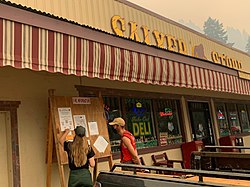
 Salyer Store in Salyer, California. | |
 Salyer, California | |
| Coordinates: 40°53′24″N 123°35′04″W | |
| Country | United States |
| State | California |
| County | Trinity |
| Elevation | 620 ft (190 m) |
| Population (2020) | |
| • Total | 389 |
| Time zone | UTC-8 (Pacific (PST)) |
| • Summer (DST) | UTC-7 (PDT) |
| ZIP code | 95563 |
| Area code | 530 |
| GNIS feature ID | 232346[1] |
History
Salyer was established on April 16, 1918, and named for Charles Marshall Salyer, a prominent miner.[2] Salyer is located in the ancestral territory of the Tsnungwe Tribe and is next to the Tsnungwe village of miy-me'. Prior to being named Salyer, a Tsnungwe Indian Dickson Dartt proposed the area be named after the village of miy-me.[3]
The ZIP Code is 95563. The community is inside area code 530.
Government
In the California State Legislature, Salyer is in the 2nd Senate District, represented by Democrat Mike McGuire, and in the 2nd Assembly District, represented by Democrat Jim Wood.[4]
In the United States House of Representatives, Salyer is in California's 2nd congressional district, represented by Democrat Jared Huffman.[5]
Climate
This region experiences warm (but not hot) and dry summers, with no average monthly temperatures above 71.6 °F. According to the Köppen Climate Classification system, Salyer has a warm-summer Mediterranean climate, abbreviated "Csb" on climate maps.[6]
See also
References
- "Salyer". Geographic Names Information System. United States Geological Survey, United States Department of the Interior.
- Capace, Nancy (1999). Encyclopedia of California. North American Book Dist LLC. Page 399. ISBN 9780403093182.
- Tsnungwe Place Names, by Tsnungwe Tribal Elders, 1994
- "Statewide Database". UC Regents. Retrieved December 6, 2014.
- "California's 2nd Congressional District - Representatives & District Map". Civic Impulse, LLC. Retrieved March 1, 2013.
- Climate Summary for Salyer, California
Другой контент может иметь иную лицензию. Перед использованием материалов сайта WikiSort.org внимательно изучите правила лицензирования конкретных элементов наполнения сайта.
WikiSort.org - проект по пересортировке и дополнению контента Википедии
