world.wikisort.org - USA
Salem Heights is a census-designated place (CDP) in Anderson Township, Hamilton County, Ohio, United States, adjacent to the city of Cincinnati. The population of Salem Heights was 3,839 at the 2010 census.[4]
Salem Heights, Ohio | |
|---|---|
Census-designated place | |
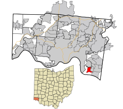 Location in Hamilton County and the state of Ohio | |
| Coordinates: 39°4′29″N 84°22′58″W | |
| Country | United States |
| State | Ohio |
| County | Hamilton |
| Area | |
| • Total | 1.63 sq mi (4.21 km2) |
| • Land | 1.63 sq mi (4.21 km2) |
| • Water | 0.00 sq mi (0.00 km2) |
| Elevation | 725 ft (221 m) |
| Population (2020) | |
| • Total | 3,862 |
| • Density | 2,375.15/sq mi (916.95/km2) |
| Time zone | UTC-5 (Eastern (EST)) |
| • Summer (DST) | UTC-4 (EDT) |
| FIPS code | 39-70050[3] |
| GNIS feature ID | 1056507[2] |
Geography
Salem Heights is located at 39°4′29″N 84°22′58″W,[5] 10 miles (16 km) east of downtown Cincinnati. The Cincinnati neighborhood of Mount Washington is directly to the north. The census-designated place of Fruit Hill lies to the east, and to the south are Interstate 275 and the Ohio River.
According to the United States Census Bureau, the Salem Heights CDP has a total area of 1.7 square miles (4.3 km2), all land.[4]
Demographics
| Historical population | |||
|---|---|---|---|
| Census | Pop. | %± | |
| 2020 | 3,862 | — | |
| U.S. Decennial Census[6] | |||
References
- "ArcGIS REST Services Directory". United States Census Bureau. Retrieved September 20, 2022.
- "US Board on Geographic Names". United States Geological Survey. 2007-10-25. Retrieved 2008-01-31.
- "U.S. Census website". United States Census Bureau. Retrieved 2008-01-31.
- "Geographic Identifiers: 2010 Demographic Profile Data (G001): Salem Heights CDP, Ohio". U.S. Census Bureau, American Factfinder. Archived from the original on February 12, 2020. Retrieved November 15, 2012.
- "US Gazetteer files: 2010, 2000, and 1990". United States Census Bureau. 2011-02-12. Retrieved 2011-04-23.
- "Census of Population and Housing". Census.gov. Retrieved June 4, 2016.
Municipalities and communities of Hamilton County, Ohio, United States | ||
|---|---|---|
County seat: Cincinnati | ||
| Cities |  | |
| Villages | ||
| Townships | ||
| CDPs |
| |
| Other communities |
| |
| Footnotes | ‡This populated place also has portions in an adjacent county or counties | |
| ||
This Hamilton County, Ohio state location article is a stub. You can help Wikipedia by expanding it. |
Текст в блоке "Читать" взят с сайта "Википедия" и доступен по лицензии Creative Commons Attribution-ShareAlike; в отдельных случаях могут действовать дополнительные условия.
Другой контент может иметь иную лицензию. Перед использованием материалов сайта WikiSort.org внимательно изучите правила лицензирования конкретных элементов наполнения сайта.
Другой контент может иметь иную лицензию. Перед использованием материалов сайта WikiSort.org внимательно изучите правила лицензирования конкретных элементов наполнения сайта.
2019-2025
WikiSort.org - проект по пересортировке и дополнению контента Википедии
WikiSort.org - проект по пересортировке и дополнению контента Википедии