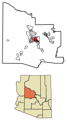
Prescott Valley is a town located in Yavapai County, Arizona, United States, approximately 8 miles (13km) east of Prescott, which it has surpassed in population. Prescott Valley was the seventh fastest-growing place among all cities and towns in Arizona between 1990 and 2000, with a current population in 2019 of about 46,515 residents.[2]
Prescott Valley's Fitzmaurice Ruins contain artifacts from the early Mountain Patayan people who inhabited the area some 1,400 years ago.[3]
The Walker Party discovered gold along Lynx Creek[4] in 1863. The Lynx Creek placers went on to produce a recorded 29,000 troy ounces (900kg) of gold. Estimates of actual production range up to 80,000 troy ounces (2,500kg), which would be worth about $138 million at 2020 prices.[5]
Prescott Valley, formerly known as Lonesome Valley, was settled by ranchers in the 1880s, raising beef to supply the miners and new settlers. The Fain family, pioneer ranchers, still ranch in the valley.[6]
Thomas Gibson Barlow-Massicks arrived in the area in the early 1890s and built the historic "castle" that still stands in Fain Park. Massicks had a hydraulic gold mining operation in Lynx Creek Canyon and built the company mining camp of Massicks, Arizona just east of his Victorian home, the castle. The fireplace with chimney just inside the castle's fence is all that remains of the Massicks store. Massicks accidentally shot himself and died in April 1899 at the age of 37. In the 1930s, there was a gold dredging operation, the Doodle Bug Diggings, farther east in Lynx Creek Canyon.[7]
In the mid-1960s, Prescott Valley Incorporated, a real-estate company from Phoenix, purchased land in an area 10 miles east of Prescott known as Lonesome Valley. In 1966, representatives from Prescott Valley Inc. began traveling to the Midwest to sell home lots. By 1978, more than 1,500 residents were living in the unincorporated area now known as Prescott Valley. In 1978, 80 percent of the voters of Prescott Valley voted for incorporation as a town.[6] The Town celebrated its 40th anniversary during 2018.
In 1985, Prescott Valley got its first licensed radio station. The station was the first solar powered FM station in the United States. Today, Arizona's Hometown Radio Group has grown to seven stations throughout Arizona.[8]
Geography
Prescott Valley (locally, PV) is located in central Arizona approximately 85 miles (137km) north of Phoenix at 5,100 feet (1,600m). elevation. PV has good access to Arizona State Route 89, SR-89A and SR-69, connecting to Interstates 17 and 40. Air service is available at Ernest A. Love Field, approximately 8 miles (13km) northwest.
One of PV's landmarks, Glassford Hill (elevation 6,177 feet (1,883m)) was an active volcano between 10 and 14 million years ago.[9] Colonel William A. Glassford traveled the area in the 1880s and helped build a system of 27 heliograph stations to monitor the movements of Apache Indians, U.S. military troops and civilians. Glassford Hill was a part of that early communications system.[10]
Prescott Valley is part of the West region of Arizona, including the Mohave, La Paz, and Yuma counties, which collectively increased their population by 25 percent between 2000 and 2010.[12]
According to 2017 census estimates,[13] there were 44,466 people and 16,705 households residing in the town. The racial makeup of the town was 76.8% non-Hispanic White, 0.7% Black or African American, 0.5% Native American, 1.2% Asian, 0% Pacific Islander and 2.1% from two or more races. 18.9% of the population were Hispanic or Latino of any race.
According to the census of 2000, there were 8,964 households, out of which 33.3% had children under the age of 18 living with them, 59.5% were married couples living together, 10.3% had a female householder with no husband present, and 26.0% were non-families. 19.8% of all households were made up of individuals, and 8.9% had someone living alone who was 65 years of age or older. The average household size was 2.60 and the average family size was 2.96.
In the town the population was spread out, with 26.8% under the age of 18, 7.3% from 18 to 24, 27.4% from 25 to 44, 21.3% from 45 to 64, and 17.2% who were 65 years of age or older. The median age was 37 years. For every 100 females there were 96.4 males. For every 100 females age 18 and over, there were 92.9 males.
The median income for a household in the town was $34,341, and the median income for a family was $37,257. Males had a median income of $30,097 versus $21,049 for females. The per capita income for the town was $16,248. About 7.8% of families and 10.9% of the population were below the poverty line, including 13.9% of those under age 18 and 6.7% of those age 65 or over.
Economy
Prescott Valley's economy consists of industrial, manufacturing, retail and service businesses. Many retirees live there due to relatively inexpensive housing and the mild climate.
Top employers
According to the Prescott Valley Economic Development Foundation,[14] the top employers in the town as of September 2019 are:
#
Employer
# of Employees
1
Humboldt Unified School District
804
2
Yavapai Regional Medical Center East
733
3
MI Windows and Doors
350
4
Walmart
329
5
Town of Prescott Valley
318
6
Ace Hardware Retail Support Center
255
7
Fry's Food and Drug
230
8
Mountain Valley Regional Rehabilitation Hospital
225
9
Home Depot
138
10
PrintPak Inc.
128
11
Superior Industries
125
12
Yavapai College – Prescott Valley Campus
123
13
Safeway, Inc.
122
14
Leidos
115
15
Yampa Precision
95
Culture
Prescott was the location of Arizona's first Elks Lodge (BPOE). In December 1895 a group of enterprising businessmen in Prescott, sturdy products of the early west, chartered the original petition for a dispensation and later established the Prescott Elks Lodge #330. "Mother Lodge of Arizona" The Prescott Elks Opera House was built by the lodge in 1905. The Prescott Elks Lodge is now located in Prescott Valley and has served the community for more than 116 years.
Attractions
Prescott Valley is located within 10 minutes of the Prescott National Forest, with lakes, fishing, hiking and camping. The Entertainment District is located downtown and offers a variety of restaurants, a 6,000-seat events center,[15] a multi-screen movie theater, and retail shops. There are 27 parks. Fain Park preserves remnants of early 20th century gold mining along Lynx Creek.[16][17]
Sports
The Northern Arizona Suns, a minor league basketball team in the NBA G League, played out of the Findlay Toyota Center from 2016 to 2020.
The Arizona Sundogs minor professional ice hockey team called Prescott Valley its home from 2006 to 2014. The team won the Central Hockey League championship in 2008.
The Arizona Adrenaline indoor football team also played two seasons in the Tim's Toyota Center (now the Findlay Toyota Center.) A new team, the Northern Arizona Wranglers of the Indoor Football League, began play in 2021 and won the league's National Championship in 2022.
Prescott Valley's Mountain Valley Splash is an outdoor community pool that seasonally offers children's swim lessons, water aerobics, school swim team practices, and recreational swim. The pool features a splash pad, fountains and a water slide.
Fain Park
Part of a series of the
Cities, towns and CDPs in Arizona with lists and images of historic properties, forts, cemeteries or historic districts
The Fain family, who were one of the original pioneer families to settle in Prescott Valley, donated the land in which Fain Park is located to the citizens of Prescott Valley. The Fain Lake is located within the park. Also located in the park is the Victorian British Manor known as “The Castle”. The structure was built in 1891, by English entrepreneur Thomas Gibson Barlow-Massicks. Barlow-Massicks established a gold mining operation and some of the equipment which he used is on display there. The Chapel of the Valley opened in 2002. The stained glass windows of the chapel, made in 1906 in Germany, once belonged to the Mercy Hospital which burned to the ground in 1940. Henry Lovell Brooks (1912–2006), an educator and organist for the First Congregational Church in Prescott, helped build the Chapel of the Valley and donated the windows and a 1877 Estey Reed Pipe Organ. Fain Park was listed in the National Register of Historic Places, as part of the Lynx Creek District, on August 31, 1978, reference # 78000571. Fain Park is located at south of Arizona State Route 69 and east of Stoneridge Drive.[18]
Pictured are the following:
The Lynx Creek District National Register of Historic Places marker.
The Fain Park waterfall
The Fain Park Bridge over Fain Lake.
The Lynx Creek Dam.
A 30” diameter pipe constructed from individual tubes, riveted together to control the flow of water during the hydraulic gold mining process.
A refurbished Gold Stamp Mill and other mining equipment.
The Barlow-Massicks Victorian British Manor "The Castle" and the manor's storage shack and tool shed.
The ruins of what was once the Massicks Stage Stop and Post Office and, plus that of a wagon.
A 1906 Stained Glass window and dedication in the Chapel of the Valley.
The 1877, Estey Reed Pipe Organ which Henry Lovell Brooks donated to the Chapel of the Valley.
Chapel of the Valley marker.
Fain Park Lynx Creek District
National Register of Historic Places Marker
Fain Park-Lynx Creek District Marker
Fain Lake waterfall
People on the historic Fain Lake Bridge
The Lynx Creek Dam
30” diameter pipe
Refurbished Gold Stamp Mill
Gold mining equipment
Barlow-Massicks Victorian British Manor "The Castle"
Barlow-Massicks Victorian British Manor storage shack
Barlow-Massicks Victorian British Manor tool shed
Ruins of the 1890 Massicks Stage Stop and Post Office
Close-up view of the Massicks Stage Stop and Post Office ruins
Abandoned wagon by the ruins of the Massicks Stage Stop and Post Office
Chapel of the Valley
1906 Stained Glass window
Stained Glass Windows dedication
1877 Estey Reed Pipe Organ
Chapel of the Valley Marker
Transportation
There are three main thoroughfares in and around Prescott Valley which include Arizona State Route 89A, Arizona State Route 69 and Fain Road. Arizona State Route 89A is a four lane divided highway that connects Prescott Valley to northern Prescott and Ernest A. Love Field Airport to the west and to the east Jerome, Cottonwood and Sedona. Arizona State Route 69 is a six lane roadway that connects Prescott Valley to downtown Prescott and Interstate 17. Fain Road is a four lane limited access freeway that links Arizona State Route 89A and Arizona State Route 69 in the east. In 2006 the town of Prescott Valley proposed the Great western Corridor from Arizona State Route 89A to Outer Loop road in Chino Valley, Arizona.[19]
Notable people
Sharlot Hall's family had a ranch between present-day Prescott Valley and Dewey. She lived there from 1890 to about 1925.[20]
Teixeira, Ruy (2012). America's New Swing Region: Changing Politics and Demographics in the Mountain West. Brookings Institution Press. ISBN9780815722861.
Другой контент может иметь иную лицензию. Перед использованием материалов сайта WikiSort.org внимательно изучите правила лицензирования конкретных элементов наполнения сайта.
2019-2025 WikiSort.org - проект по пересортировке и дополнению контента Википедии
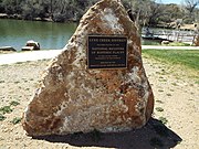 Fain Park-Lynx Creek District Marker
 Fain Lake waterfall
 People on the historic Fain Lake Bridge
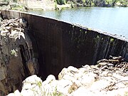 The Lynx Creek Dam
 30” diameter pipe
 Refurbished Gold Stamp Mill
 Gold mining equipment
 Barlow-Massicks Victorian British Manor "The Castle"
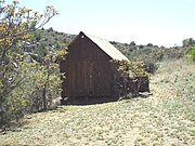 Barlow-Massicks Victorian British Manor storage shack
 Barlow-Massicks Victorian British Manor tool shed
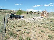 Ruins of the 1890 Massicks Stage Stop and Post Office
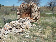 Close-up view of the Massicks Stage Stop and Post Office ruins
 Abandoned wagon by the ruins of the Massicks Stage Stop and Post Office
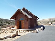 Chapel of the Valley
 1906 Stained Glass window
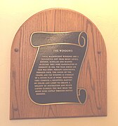 Stained Glass Windows dedication
 1877 Estey Reed Pipe Organ
 Chapel of the Valley Marker