 Ash Fork Maintenance Camp No.1
 Ashfork-Bainbridge Steel Dam in 1922
 1903 Bar and Brothel
 1903 General Store
 Remains of the 1907 Escalante Harvey House and Hotel
 Route 66 Copper State Motel – 1930
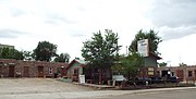 Different view of the Route 66 Copper State Motel – 1930
 Route 66 Stagecoach 66 Motel – 1930
 1958 Texaco Station (now De Soto's Salon) on Route 66
 1933 Yavapai Trading Post on Route 66
world.wikisort.org - USA
Ash Fork is a census-designated place in Yavapai County, Arizona, United States. Its population was 396 at the 2010 U.S. Census, down from 457 in 2000.
Ash Fork, Arizona | |
|---|---|
CDP | |
 Ash Fork Centennial Marker | |
 Location in Yavapai County and the state of Arizona | |
 Ash Fork, Arizona Location in the United States | |
| Coordinates: 35°13′16″N 112°29′14″W | |
| Country | United States |
| State | Arizona |
| County | Yavapai |
| Area | |
| • Total | 2.31 sq mi (5.98 km2) |
| • Land | 2.31 sq mi (5.98 km2) |
| • Water | 0.00 sq mi (0.00 km2) |
| Elevation | 5,160 ft (1,573 m) |
| Population (2020) | |
| • Total | 361 |
| • Density | 156.48/sq mi (60.41/km2) |
| Time zone | UTC-7 (MST) |
| ZIP code | 86320 |
| Area code | 928 |
| FIPS code | 04-04440 |
| GNIS feature ID | 25794 |
| Part of a series of the |
| Cities, towns and CDPs in Arizona with lists and images of historic properties, forts, cemeteries or historic districts |
|---|
 |
Geography
Ash Fork is located at 35°13′16″N 112°29′14″W (35.221236, -112.487100).[2] According to the United States Census Bureau, the CDP has a total area of 2.3 sq mi (6.0 km2), all land.
Geologic places of interest include the Cathedral Caves, which are about 10 miles (16 km) west of town off Arizona Road, and Dante's Descent, a 275-foot (84 m) -deep sinkhole also known as "Devil's Hole", which is around 5 miles northwest of Ash Fork, off Crookton Road. After its closing by the state, however, Dante's Descent cannot legally be visited by the public. Pictorial and historic documentation of the natural attraction may be found at the Ash Fork Library.
Ash Fork lies near Kaibab National Forest and Coconino National Forest, and international attractions such as the Grand Canyon are roughly an hour's drive away using major roads. Service roads allow swifter access to back areas of Grand Canyon National Park, but may not be open to public thoroughfare.
Approximately 15 miles (24 km) to the north of Ash Fork is Beale Road, which has the distinction of being the first federally funded highway. The internationally renowned U.S. Route 66 also runs directly through the town. Notably, the longest original, uninterrupted stretch of Route 66 still in existence (about 9.6 miles (15.4 km) long) can be found between Ash Fork and Seligman, Arizona, beginning just beyond Ash Fork at Crookton Road. The surrounding geographical area and settlements served as inspiration for the 2006 Pixar film Cars.[3]
History
Ash Fork has proclaimed itself "The Flagstone Capital of the World", due to the large number of stone quarries and stone yards in and around the town.[4] The title of "Flagstone Capital of the World," was bestowed upon Ash Fork by the Ash Fork Development Association and Ash Fork Historical Society. The title was officially bestowed upon the town in 2014 by the Arizona House of Representatives with the passage of H.R. 2001.[5]
The community was established as a siding of the Atlantic and Pacific Railroad, later known as the Santa Fe Railroad, in October 1882. It was purportedly named in 1883 by F.W. Smith, general superintendent of the railroad, in reference to a thicket of ash trees at the site.[4] The first official post office was established on April 12, 1883, with one Henry W. Kline serving as the first Postmaster.[6] Following an uncontrollable fire in 1885, the entire town of Ash Fork burned in 1893, and was rebuilt on the opposite side of the railroad tracks from its original location, where it remains today.
In later years, Ash Fork was the location of the Escalante, a large hotel and "Harvey House" built in 1907 and closed in 1948, operated by the Fred Harvey Company. Ash Fork's convenient location along the railway and later famous U.S. Route 66 made it recognizable to many cross-country travelers, as evidenced by its fleeting mention in several films from the era of classical Hollywood cinema such as 1947's Dark Passage, starring Humphrey Bogart and Lauren Bacall.
U.S. Route 66 provided a slight boost to the town's economy in the 1950s, but construction of the divided highway through the town resulted in the destruction of many of the storefronts, sidewalks, and residential streets, forever altering the aesthetic qualities of the downtown area.[4] When the Santa Fe Railroad moved its main line north and away from the town in 1960, Ash Fork lost nearly half its population, as most families employed by the railway were forced to leave the area.[4]
Another large fire, known locally as the "Big Fire", devastated the community on November 20, 1977, destroying most of the downtown businesses. When I-40 bypassed the town soon after, drastically reducing traffic on Route 66, the local economy never fully recovered. The community's last major fire occurred on October 7, 1987, destroying nearly all the remaining buildings along the two-block business district located on the south side of Route 66.[4]
Part of what was once Route 66 still runs directly through Ash Fork, though as a divided highway, with Park Avenue running east and Lewis Avenue running west, both serving as a main thoroughfare. Historic buildings, including a false-front structure and old railroad company houses can be seen along these streets. The majority of the town's limited commercial establishments, including the Oasis Lounge and the Ranch House Cafe, can be found along Park Avenue. The Ash Fork Post Office is also located on this street.[7]
Certain areas of the town were selected to be used as sets in the filming of 1992's Universal Soldier, supposedly due to the extremely low purchase price and poor condition of several buildings, including an old motel, which were blown up for cinematic effect.[4]
Demographics
| Historical population | |||
|---|---|---|---|
| Census | Pop. | %± | |
| 1910 | 517 | — | |
| 1920 | 571 | 10.4% | |
| 1930 | 894 | 56.6% | |
| 1960 | 681 | — | |
| 2000 | 457 | — | |
| 2010 | 396 | −13.3% | |
| 2020 | 361 | −8.8% | |
| U.S. Decennial Census[8] | |||
Ash Fork (or Ashfork) first appeared on the 1910 U.S. Census as an unincorporated village with 517 residents, the fourth-largest community in Yavapai County (behind Prescott, Jerome, and Humboldt).[9] Although it did not report a separate population for the village, it did report as the Ash Fork precinct in 1920[10] and 1930 (reporting a majority White population in the latter).[11] The population of Ash Fork was 681in the 1960 census.[12] In 2000, it was made a census-designated place (CDP).
As of the census[13] of 2000, 457 people, 149 households, and 109 families were residing in the CDP. The population density was 199.1 people.sq mi (76.7/km2). The 189 housing units had an average density of 82.3/sq mi (31.7/km2). The racial makeup of the CDP was 96.3% White, 1.3% Native American, 1.5% from other races, and 0.9% from two or more races. Hispanics or Latinos of any race were 51.4% of the population.
Of the 149 households, 35.6% had children under 18 living with them, 54.4% were married couples living together, 6.7% had a female householder with no husband present, and 26.2% were not families. About 22.1% of all households were made up of individuals, and 10.1% had someone living alone who was 65 or older. The average household size was 3.07, and the average family size was 3.45.
In the CDP, the age distribution was 28.7% under 18, 13.6% from 18 to 24, 25.2% from 25 to 44, 21.4% from 45 to 64, and 11.2% who were 65 or older. The median age was 34 years. For every 100 females, there were 161.1 males. For every 100 females age 18 and over, there were 143.3 males.
The median income for a household in the CDP was $30,893, and for a family was $36,875. Males had a median income of $23,854 versus $21,094 for females. The per capita income for the CDP was $11,802. About 16.5% of families and 20.4% of the population were below the poverty line, including 27.1% of those under age 18 and 18.4% of those age 65 or over.
The numerous flagstone quarries and companies are often cited as the largest employers in the area, as is the local school district, to which most teachers commute from nearby cities.
Historic Ash Fork and Route 66
| Part of a series of the |
| Cities, towns and CDPs in Arizona with lists and images of historic properties, forts, cemeteries or historic districts |
|---|
|
Pictured are some of the historic structures in the Town of Ash Fork; some of these structures or ruins are listed in the National Register of Historic Places, while others were significant during the years that the historic Route 66 was commonly used by motorists.
- The Ash Fork Maintenance Camp #1, built circa 1926–27 by the Arizona Department of Transportation, this building constructed of Moenkopi Sandstone, has been listed on the National Register of Historic Places.
- The Ashfork Bainbridge Steel Dam was constructed in 1898 by the Atchison, Topeka and Santa Fe Railway (ATSF) to supply water for railway operations near Ash Fork. It is the first large steel dam in the world, and one of only three ever built in the United States.[14] The dam was listed on the National Register of Historic Places in 1976.
- Bar and Brothel, built in 1903, the first floor of this structure served as a bar, while the second floor served as a house of prostitution.
- General Store – an old abandoned building, built c. 1903, which once served as the community general grocery store.
- “The Famous Esclante Hotel, according to the historical marker by the Ash Fork Historical Society, opened March 1, 1907, and was built of steel and concrete in the Mission Style of Spanish architecture. The hotel covered a space of 420 X 200 ft. Its cost was approximately $115,000.[15]
- Copper State Motel, built in 1930, is located at 101 Lewis Ave. on Route 66; it was originally opened by Zelma and Ezell Nelson as the "Copper State Modern Cottages".
- The Stage Coach Motel, built in 1939, is located at 823 W. Park Ave. on Route 66.
- The DeSoto's Salon, built in 1957, is located at 314 W Lewis Ave. and was originally a Texaco service station. It has a Chrysler DeSoto car (an early 1960s model) on its roof, which was once driven by Elvis Presley. The building now serves as a beauty parlor and barber shop.[16]
- The Yavapai Trading Post, built in 1933, is also located on Route 66.
Historic Ash Fork and Route 66


Education
It is in the Ash Fork School District.[17]
Climate
This region experiences warm (but not hot) and dry summers, with no average monthly temperatures above 89 °F. According to the Köppen climate classification, Ash Fork has a warm-summer Mediterranean climate, Csb on climate maps.[18]
Notable person
- Adam Kokesh, libertarian political activist
References
- "2020 U.S. Gazetteer Files". United States Census Bureau. Retrieved October 29, 2021.
- "US Gazetteer files: 2010, 2000, and 1990". United States Census Bureau. 2011-02-12. Retrieved 2011-04-23.
- Internet Movie Database. The Inspiration for 'Cars. (2006), with Angel Delgadillo, barber and John Lasseter, director.
- Trimble, Marshall. Ash Fork. Arcadia, 2008.
- http://legiscan.com/AZ/bill/HR2001/2014/ House Resolution 2001 of 2014, Designation of Ash Fork as "Flagstone Capital"
- Barnes, Will C.; Granger, Byrd (ed.) Arizona Place Names University of Arizona Press, 1997. p. 30
- Kaszynski, William. Route 66: Images of America's Main Street. McFarland, 2003.
- "Census of Population and Housing". Census.gov. Retrieved June 4, 2016.
- https://www2.census.gov/prod2/decennial/documents/41033935v1-8ch2.pdf [bare URL PDF]
- http://www2.census.gov/prod2/decennial/documents/06229686v1-7ch02.pdf [bare URL PDF]
- https://www2.census.gov/prod2/decennial/documents/10612963v3p1ch02.pdf [bare URL PDF]
- "Arizona". World Book Encyclopedia. Vol. A. Chicago: Field Enterprises Educational Corporation. 1960. p. 557.
- "U.S. Census website". United States Census Bureau. Retrieved 2008-01-31.
- Arizona Society of Civil Engineers 150th anniversary booklet
- "The Famous Esclante Hotel”
- Ash Fork Route 66
- "2020 CENSUS - SCHOOL DISTRICT REFERENCE MAP: Yavapai County, AZ" (PDF). U.S. Census Bureau. Retrieved 2022-01-24.
- Climate Summary for Ash Fork, Arizona
External links
Wikimedia Commons has media related to Ash Fork, Arizona.
Wikivoyage has a travel guide for Ash Fork.
- Ash Fork Community Profile (Arizona Dept. of Commerce)
- Ashfork – Flagstone Capital of the World
- Ash Fork Local History
- Ash Fork Historical Marker
Municipalities and communities of Yavapai County, Arizona, United States | ||
|---|---|---|
County seat: Prescott | ||
| Cities |  | |
| Towns |
| |
| CDPs | ||
| Populated places |
| |
| Indian reservations |
| |
| Ghost towns | ||
| Footnotes | ‡This populated place also has portions in an adjacent county or counties | |
| ||
Authority control | |
|---|---|
| General |
|
| National libraries | |
На других языках
[de] Ash Fork
Ash Fork ist ein Census-designated place im Yavapai County im US-Bundesstaat Arizona.- [en] Ash Fork, Arizona
Текст в блоке "Читать" взят с сайта "Википедия" и доступен по лицензии Creative Commons Attribution-ShareAlike; в отдельных случаях могут действовать дополнительные условия.
Другой контент может иметь иную лицензию. Перед использованием материалов сайта WikiSort.org внимательно изучите правила лицензирования конкретных элементов наполнения сайта.
Другой контент может иметь иную лицензию. Перед использованием материалов сайта WikiSort.org внимательно изучите правила лицензирования конкретных элементов наполнения сайта.
2019-2026
WikiSort.org - проект по пересортировке и дополнению контента Википедии
WikiSort.org - проект по пересортировке и дополнению контента Википедии