world.wikisort.org - USA
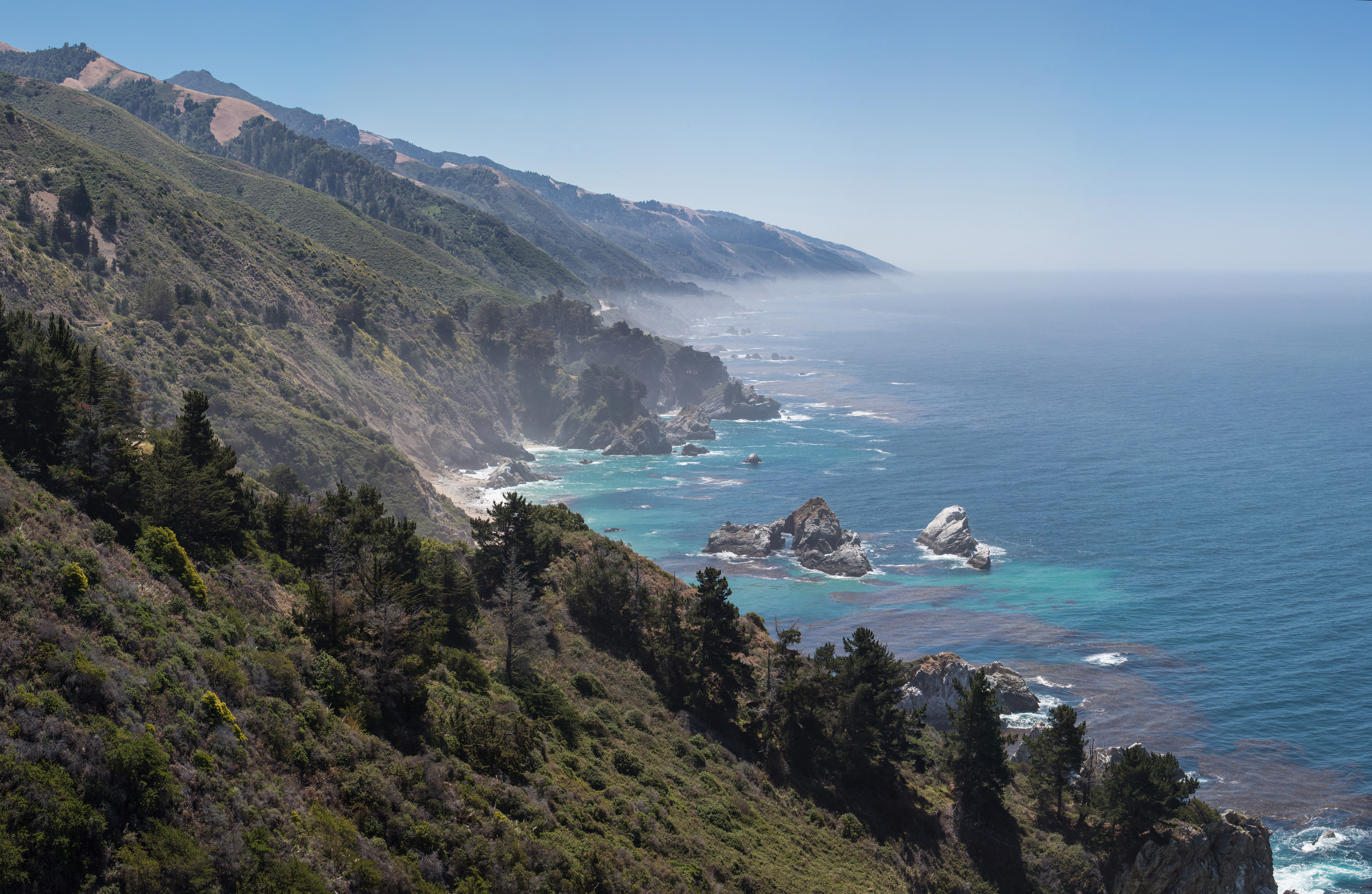
Plaskett is a thinly populated oceanside hamlet alongside the Big Sur Coast Highway in the southern Big Sur region of Monterey County, California.[1] It lies at an elevation of 203 feet (62 m).[1] It consists of a USFS campground and station, two small resorts, a small school, and a few dozen families spread over the general region.
Plaskett | |
|---|---|
Unincorporated community | |
 Plaskett Location in California | |
| Coordinates: 35°55′00″N 121°28′08″W | |
| Country | United States |
| State | California |
| County | Monterey County |
| Elevation | 203 ft (62 m) |
Attractions and services
Camping and hiking
The USFS Plaskett Creek Campground has 44 campsites. The campground is on the east side of Highway 1 in a forest of Monterey Pine, Cypress, and Cedar trees. There are three group campsites for tent and RV camping. There are no hookups or a dump station. Each site is equipped with a table and campfire ring with grill. Flush toilets, sinks and drinking water are provided throughout the campground.[2][3] Camping alongside Highway 1 or other local roads is illegal. Due to high fire danger, campfires and BBQ usage are only permitted in designated campgrounds.[4]
The campground is walking distance to Sand Dollar Beach, the longest publicly accessible strand of sandy beach along the Big Sur coast.[5][6] A quarter mile south of the Plaskett Creek Campground, there is a 1.5 miles (2.4 km) coastal trail from Jade Cove to Plaskett Rock Point.
The 1.1 miles (1.8 km) Pacific Valley Bluff Trail is across Highway 1 from the Pacific Valley Ranger Station, and 1 mile (1.6 km) north of the Plaskett Creek Campground offers a short walk to the sea side bluffs with views of the Santa Lucia Range to the north and Sand Dollar Beach to the south.[7]
The Pacific Valley Ranger Station is 1.3 miles (2.1 km) north of Plaskett. There are restrooms and a public telephone. There is no cell coverage or wifi service in the area. The nearest services are in Gorda 3.9 miles (6.3 km) south and in Lucia, 9.5 miles (15.3 km) to the north.[5] The Treebones Resort 3.4 miles (5.5 km) to the south offers high-end accommodations in yurts and meals at the Wild Coast Restaurant.[8]
Junge Cabin
The Junge Cabin, a one-room redwood cabin built in 1920 by homesteader John Junge, is found in Pacific Valley.[9]
Jade Cove
There is a steep 0.1 miles (0.16 km) trail from the Plaskett Campground to Jade Cove that ends in a rope-assisted drop to the beach. The beach can be dangerous during high tides and storms.[10] The Monterey Bay National Marine Sanctuary permits individuals to collect loose jade from an area south of Sand Dollar Beach to Cape San Martin and up to 90 feet (27 m) deep offshore. Individuals may remove only what they can individually carry. Only hand tools are permitted.[11]
Education
The Pacific Valley School offers K-12 education to south coast residents. In 2017–18, the school had 22 students and a student/teacher ratio of 3:1.[12][13]
Etymology
William and Sarah (Barnes) Plaskett, after whom the place is named, claimed a homestead in the area now known as Gorda 3.9 miles (6.3 km) south of Plaskett in 1869 and established a saw mill.[14]: 38 [15][16] The family name is connected to Plaskett Creek, Plaskett Creek Campground, Plaskett Rock, Plaskett Ridge, and Plaskett Ridge Road. Two plant specimens were also named for the family: Nemophila plaskettii and Linanthus plaskettii, which today are recognized as synonyms for Nemophila parviflora, also known as Baby Blue Eyes.[17][18]
Government
At the county level, Plaskett is represented on the Monterey County Board of Supervisors by Supervisor Dave Potter.[19]
In the California State Legislature, Plaskett is in the 17th Senate District, represented by Democrat John Laird, and in the 30th Assembly District, represented by Democrat Robert Rivas.[20]
In the United States House of Representatives, Plaskett is in California's 20th congressional district, represented by Democrat Jimmy Panetta[21]
References
- U.S. Geological Survey Geographic Names Information System: Plaskett, California
- "Best Campgrounds In Big Sur With Incredible Views". ROAD TRIP USA. Retrieved 8 December 2020.
- "Plaskett Creek - Campsite Photos, Campsite Availability Alerts". Campsite Photos. Retrieved 8 December 2020.
- "Big Sur Camping Guide, Big Sur California". www.bigsurcalifornia.org. Retrieved 11 December 2020.
- "Plaskett Creek Campground". Los Padres National Forest. United States Department of Agriculture. Retrieved 8 December 2020.
- "Big Sur Beach Guide, Big Sur California". www.bigsurcalifornia.org. Retrieved 8 December 2020.
- Smigelski, Seth. "Pacific Valley Bluff Trail | Big Sur | Hikespeak.com". www.hikespeak.com. Retrieved 8 December 2020.
- "Wild Coast Restaurant & The Sushi Bar". Treebones Resort. Retrieved 8 December 2020.
- JRP Historical Consulting Services (November 2001). "Big Sur Highway Management Plan" (PDF). Corridor Intrinsic Qualities Inventory Historic Qualities Summary Report. Caltrans. p. 38. Archived (PDF) from the original on September 5, 2008. Retrieved November 14, 2009.
- Smigelski, Seth Copyright. "Jade Cove and Plaskett Rock Point Trail | Big Sur | Hikespeak.com". www.hikespeak.com. Retrieved 8 December 2020.
- "MBNMS: Jade Collection Areas". montereybay.noaa.gov. Retrieved 10 December 2020.
- "Pacific Valley School - Pacific Valley School (Big Sur)". www.bigsurunified.org. Retrieved 8 December 2020.
- "School Accountability Report Card" (PDF). bigsurunified.org. Big Sur Unified School District. p. 4. Retrieved 8 December 2020.
- "Los Padres National Forest (N.F.), Big Sur Coastal Unit Plan: Environmental Impact Statement". United States. Forest Service. 1977. Retrieved 9 March 2018.
- Alderson, Bill "Bull Plaskett" (3 October 2020). "Links to Coast history | Plaskett.family". Retrieved 8 December 2020.
- Rogers, David. "DCQ Fall Equinox 1999 -- Ribes (Gooseberries and Currants)". www.ventanawild.org. Retrieved 8 December 2020.
- "Nemophila | plant genus". Encyclopedia Britannica. Retrieved 8 December 2020.
- "Nemophila parviflora Douglas ex Benth. | Plants of the World Online | Kew Science". Plants of the World Online. Retrieved 8 December 2020.
- "Monterey County Supervisorial District 5 Map (North District 5)" (PDF). County of Monterey. Archived from the original (PDF) on 1 July 2012. Retrieved 21 September 2012.
- "Statewide Database". UC Regents. Archived from the original on February 1, 2015. Retrieved February 11, 2015.
- "California's 20th Congressional District - Representatives & District Map". Civic Impulse, LLC. Retrieved September 24, 2014.
Municipalities and communities of Monterey County, California, United States | ||
|---|---|---|
County seat: Salinas | ||
| Cities |  | |
| CDPs | ||
| Unincorporated communities |
| |
| CCDs |
| |
| Ghost towns |
| |
| Footnotes | ‡This populated place also has portions in an adjacent county | |
| ||
| Populated Places |
|  | |||||||||||
|---|---|---|---|---|---|---|---|---|---|---|---|---|---|
| Land Use |
| ||||||||||||
| Geographical Features |
| ||||||||||||
| Attractions |
| ||||||||||||
| Events |
| ||||||||||||
| Community |
| ||||||||||||
| Trails and Roads |
| ||||||||||||
| Famous Individuals |
| ||||||||||||
| History |
| ||||||||||||
| Flora and Fauna |
| ||||||||||||
The exact boundaries of Big Sur are loosely defined. | |||||||||||||
Другой контент может иметь иную лицензию. Перед использованием материалов сайта WikiSort.org внимательно изучите правила лицензирования конкретных элементов наполнения сайта.
WikiSort.org - проект по пересортировке и дополнению контента Википедии