world.wikisort.org - USA
Pilesgrove Township is a township in Salem County, New Jersey, United States. As of the 2010 United States Census, the township's population was 4,016,[8][9][10] reflecting an increase of 93 (+2.4%) from the 3,923 counted in the 2000 Census, which had in turn increased by 673 (+20.7%) from the 3,250 counted in the 1990 Census.[18]
Pilesgrove Township, New Jersey | |
|---|---|
Township | |
| Township of Pilesgrove | |
 Municipal Building | |
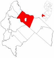 Pilesgrove Township highlighted in Salem County. Inset map: Salem County highlighted in the State of New Jersey. | |
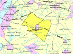 Census Bureau map of Pilesgrove Township, New Jersey | |
| Coordinates: 39.664363°N 75.395772°W[1][2] | |
| Country | |
| State | |
| County | |
| Earliest mention | April 15, 1701 |
| Incorporated | February 21, 1798 |
| Government | |
| • Type | Township |
| • Body | Township Committee |
| • Mayor | Kevin Eachus (R, term ends December 31, 2020)[4][5] |
| • Administrator / Municipal clerk | Melissa Fackler[6] |
| Area | |
| • Total | 35.17 sq mi (91.09 km2) |
| • Land | 34.94 sq mi (90.48 km2) |
| • Water | 0.23 sq mi (0.61 km2) 0.67% |
| • Rank | 69th of 565 in state 5th of 15 in county[1] |
| Elevation | 62 ft (19 m) |
| Population | |
| • Total | 4,016 |
| • Estimate (2019)[11] | 3,981 |
| • Rank | 412th of 566 in state 6th of 15 in county[12] |
| • Density | 115.3/sq mi (44.5/km2) |
| • Rank | 534th of 566 in state 8th of 15 in county[12] |
| Time zone | UTC−05:00 (Eastern (EST)) |
| • Summer (DST) | UTC−04:00 (Eastern (EDT)) |
| ZIP Code | 08098[13] |
| Area code | 856 exchange: 769[14] |
| FIPS code | 3403358530[1][15][16] |
| GNIS feature ID | 0882132[1][17] |
| Website | www |
Pile's Grove was first mentioned in a deed dated April 15, 1701, through the date of the township's original corporation is unknown. Pilesgrove was incorporated as one of New Jersey's original group of 104 townships that were established on February 21, 1798. Portions of the township were taken on December 6, 1769, to form Pittsgrove Township and on July 26, 1882, to create Woodstown.[19] The township was named for Thomas Pyle.[20][21]
In 1979, Pilesgrove Township enacted the state's first right-to-farm law, protecting farming as a "natural right hereby ordained to exist as a permitted use everywhere in the Township of Pilesgrove."[22]
Geography
According to the United States Census Bureau, the township had a total area of 35.17 square miles (91.09 km2), including 34.94 square miles (90.48 km2) of land and 0.23 square miles (0.61 km2) of water (0.67%).[1][2] The Salem River flows through the township.[23]
The township borders the Salem County municipalities of Alloway Township, Carneys Point Township, Mannington Township, Oldmans Township and Upper Pittsgrove Township. Pilesgrove Township also borders Gloucester County.[24][25] The Borough of Woodstown is an independent municipality completely surrounded by Pilesgrove Township, making it part of 21 pairs of "doughnut towns" in the state, where one municipality entirely surrounds another.[26] Woodstown serves as the more densely settled commercial core of the paired communities, while Pilesgrove is more agricultural.[27]
Unincorporated communities in the township include Avis Mills, Courees Landing, East Lake, Eldridges Hill, Fenwick, Friendship, Milltown, Paulding, Point Airy, Richmanville, Sharptown, Union Grove and Yorktown.[28] The census-designated place of Auburn is in the northwest part of the township, extending into Oldmans Township.
The Pilesgrove Solar Farm is one of the largest in the state, covering 100 acres (40 ha) with 71,000 solar panels that generate 20 megawatts of electricity, enough to provide power for more than 5,000 homes.[29]
Demographics
| Historical population | |||
|---|---|---|---|
| Census | Pop. | %± | |
| 1810 | 1,756 | — | |
| 1820 | 2,012 | 14.6% | |
| 1830 | 2,150 | 6.9% | |
| 1840 | 2,477 | 15.2% | |
| 1850 | 2,962 | 19.6% | |
| 1860 | 3,359 | 13.4% | |
| 1870 | 3,385 | 0.8% | |
| 1880 | 3,007 | −11.2% | |
| 1890 | 1,796 | * | −40.3% |
| 1900 | 1,744 | −2.9% | |
| 1910 | 1,606 | −7.9% | |
| 1920 | 1,770 | 10.2% | |
| 1930 | 1,815 | 2.5% | |
| 1940 | 1,614 | −11.1% | |
| 1950 | 1,942 | 20.3% | |
| 1960 | 2,519 | 29.7% | |
| 1970 | 2,706 | 7.4% | |
| 1980 | 2,810 | 3.8% | |
| 1990 | 3,250 | 15.7% | |
| 2000 | 3,923 | 20.7% | |
| 2010 | 4,016 | 2.4% | |
| 2019 (est.) | 3,981 | [11][30] | −0.9% |
| Population sources: 1810–2000[31] 1810–1920[32] 1840[33] 1850–1870[34] 1850[35] 1870[36] 1880–1890[37] 1890–1910[38] 1910–1930[39] 1930–1990[40] 2000[41][42] 2010[8][9][10] * = Lost territory in previous decade.[19] | |||
Census 2010
The 2010 United States census counted 4,016 people, 1,488 households, and 1,091 families in the township. The population density was 115.3 per square mile (44.5/km2). There were 1,594 housing units at an average density of 45.7 per square mile (17.6/km2). The racial makeup was 90.81% (3,647) White, 5.93% (238) Black or African American, 0.12% (5) Native American, 0.92% (37) Asian, 0.12% (5) Pacific Islander, 0.72% (29) from other races, and 1.37% (55) from two or more races. Hispanic or Latino of any race were 2.59% (104) of the population.[8]
Of the 1,488 households, 27.5% had children under the age of 18; 63.9% were married couples living together; 6.1% had a female householder with no husband present and 26.7% were non-families. Of all households, 21.5% were made up of individuals and 14.8% had someone living alone who was 65 years of age or older. The average household size was 2.62 and the average family size was 3.08.[8]
20.4% of the population were under the age of 18, 7.4% from 18 to 24, 18.8% from 25 to 44, 32.4% from 45 to 64, and 21.0% who were 65 years of age or older. The median age was 47.3 years. For every 100 females, the population had 93.7 males. For every 100 females ages 18 and older there were 93.5 males.[8]
The Census Bureau's 2006–2010 American Community Survey showed that (in 2010 inflation-adjusted dollars) median household income was $87,083 (with a margin of error of +/− $12,552) and the median family income was $102,870 (+/− $13,121). Males had a median income of $63,352 (+/− $12,197) versus $59,700 (+/− $6,558) for females. The per capita income for the borough was $34,966 (+/− $3,754). About 0.8% of families and 4.4% of the population were below the poverty line, including 9.5% of those under age 18 and 4.2% of those age 65 or over.[43]
Census 2000
As of the 2000 United States Census[15] there were 3,923 people, 1,216 households, and 994 families residing in the township. The population density was 112.4 inhabitants per square mile (43.4/km2). There were 1,261 housing units at an average density of 36.1 per square mile (13.9/km2). The racial makeup of the township was 84.63% White, 12.18% African American, 0.28% Native American, 0.92% Asian, 0.05% Pacific Islander, 1.07% from other races, and 0.87% from two or more races. Hispanic or Latino of any race were 2.98% of the population.[41][42]
There were 1,216 households, out of which 35.4% had children under the age of 18 living with them, 71.1% were married couples living together, 7.0% had a female householder with no husband present, and 18.2% were non-families. 14.9% of all households were made up of individuals, and 6.8% had someone living alone who was 65 years of age or older. The average household size was 2.91 and the average family size was 3.24.[41][42]
In the township the population was spread out, with 23.8% under the age of 18, 8.4% from 18 to 24, 27.2% from 25 to 44, 26.2% from 45 to 64, and 14.4% who were 65 years of age or older. The median age was 40 years. For every 100 females, there were 107.1 males. For every 100 females age 18 and over, there were 107.9 males.[41][42]
The median income for a household in the township was $66,042, and the median income for a family was $71,629. Males had a median income of $50,833 versus $31,806 for females. The per capita income for the township was $27,400. About 2.3% of families and 3.4% of the population were below the poverty line, including 2.8% of those under age 18 and 2.8% of those age 65 or over.[41][42]
Government
Local government
Pilesgrove is governed under the Township form of New Jersey municipal government, one of 141 municipalities (of the 564) statewide that use this form, the second-most commonly used form of government in the state.[44] The Township Committee consists of three members elected at-large in partisan elections to serve three-year terms on a staggered basis, with one seat coming up for election each year as part of the November general election in a three-year cycle.[3][45] At an annual reorganization meeting, the council selects one of its members to serves as mayor and another as deputy mayor.
As of 2022[update], members of the Pilesgrove Township Committee are Mayor Kevin Eachus (R, term on committee ends December 31, 2024; term as mayor ends 2022), Deputy Mayor David R. Bonowski (R, term on committee ends 2023; term as deputy mayor ends 2022) and Joseph Crevino (R, 2022).[4][46][47][48][49]
In August 2014, the Township Council selected Joseph Crevino to fill the vacant seat of Jessie B. Smith, who had resigned the previous month from a term expiring in December 2016.[50]
In 2018, the township had an average property tax bill of $8,387, the highest in the county, compared to an average bill of $8,767 statewide.[51]
Federal, state and county representation
Pilesgrove Township is located in the 2nd Congressional District[52] and is part of New Jersey's 3rd state legislative district.[9][53][54]
For the 117th United States Congress, New Jersey's Second Congressional District is represented by Jeff Van Drew (R, Dennis Township).[55] New Jersey is represented in the United States Senate by Democrats Cory Booker (Newark, term ends 2027)[56] and Bob Menendez (Harrison, term ends 2025).[57][58]
For the 2022–2023 session, the 3rd Legislative District of the New Jersey Legislature is represented in the State Senate by Edward Durr (R, Logan Township) and in the General Assembly by Bethanne McCarthy-Patrick (R, Mannington Township) and Beth Sawyer (R, Woolwich Township).[59]
Salem County is governed by a five-member Board of County Commissioners who are elected at-large to serve three-year terms of office on a staggered basis, with either one or two seats coming up for election each year. At an annual reorganization meeting held in the beginning of January, the board selects a Director and a Deputy Director from among its members.[60] As of 2022[update], Salem County's Commissioners (with party, residence and term-end year listed in parentheses) are Director Benjamin H. Laury (R, Elmer, term as commissioner ends December 31, 2024; term as director ends 2022), Deputy Director Gordon J. "Mickey" Ostrum, Jr. (R, Pilesgrove Township, term as commissioner ends 2024; term as deputy director ends 2022), R. Scott Griscom (R, Mannington Township, 2022), Edward A. Ramsay (R, Pittsgrove Township, 2023) and Lee R. Ware (D, Elsinboro Township, 2022).[60][61] Constitutional officers elected on a countywide basis are County Clerk Dale A. Cross (R, 2024),[62][63] Sheriff Charles M. Miller (R, 2024)[64][65] and Surrogate Nicki A. Burke (D, 2023).[66][67]
Politics
As of March 23, 2011, there were a total of 2,908 registered voters in Pilesgrove Township, of which 678 (23.3% vs. 30.6% countywide) were registered as Democrats, 873 (30.0% vs. 21.0%) were registered as Republicans and 1,354 (46.6% vs. 48.4%) were registered as Unaffiliated. There were 3 voters registered as Libertarians or Greens.[68] Among the township's 2010 Census population, 72.4% (vs. 64.6% in Salem County) were registered to vote, including 90.9% of those ages 18 and over (vs. 84.4% countywide).[68][69]
In the 2012 presidential election, Republican Mitt Romney received 56.5% of the vote (1,273 cast), ahead of Democrat Barack Obama with 42.1% (950 votes), and other candidates with 1.4% (31 votes), among the 2,278 ballots cast by the township's 2,990 registered voters (24 ballots were spoiled), for a turnout of 76.2%.[70][71] In the 2008 presidential election, Republican John McCain received 1,255 votes (53.2% vs. 46.6% countywide), ahead of Democrat Barack Obama with 1,051 votes (44.6% vs. 50.4%) and other candidates with 26 votes (1.1% vs. 1.6%), among the 2,358 ballots cast by the township's 2,911 registered voters, for a turnout of 81.0% (vs. 71.8% in Salem County).[72] In the 2004 presidential election, Republican George W. Bush received 1,246 votes (58.8% vs. 52.5% countywide), ahead of Democrat John Kerry with 845 votes (39.9% vs. 45.9%) and other candidates with 22 votes (1.0% vs. 1.0%), among the 2,120 ballots cast by the township's 2,695 registered voters, for a turnout of 78.7% (vs. 71.0% in the whole county).[73]
In the 2013 gubernatorial election, Republican Chris Christie received 70.8% of the vote (1,035 cast), ahead of Democrat Barbara Buono with 26.7% (390 votes), and other candidates with 2.5% (36 votes), among the 1,478 ballots cast by the township's 3,003 registered voters (17 ballots were spoiled), for a turnout of 49.2%.[74][75] In the 2009 gubernatorial election, Republican Chris Christie received 869 votes (50.4% vs. 46.1% countywide), ahead of Democrat Jon Corzine with 629 votes (36.5% vs. 39.9%), Independent Chris Daggett with 187 votes (10.8% vs. 9.7%) and other candidates with 18 votes (1.0% vs. 2.0%), among the 1,724 ballots cast by the township's 2,919 registered voters, yielding a 59.1% turnout (vs. 47.3% in the county).[76]
Education
The Woodstown-Pilesgrove Regional School District serves public school students in pre-kindergarten through twelfth grade from Woodstown and Pilesgrove Township.[77] As of the 2020–21 school year, the district, comprised of four schools, had an enrollment of 1,425 students and 126.5 classroom teachers (on an FTE basis), for a student–teacher ratio of 11.3:1.[78] Schools in the district (with 2020–21 enrollment data from the National Center for Education Statistics[79]) are William Roper Early Childhood Learning Center[80] with 83 students in grades PreK-K, Mary S. Shoemaker Elementary School[81] with 470 students in grades 1-5, Woodstown Middle School[82] with 278 students in grades 6-8 and Woodstown High School[83] with 579 students in grades 9-12.[84][85][86] Students from neighboring Alloway Township, Oldmans Township and Upper Pittsgrove Township attend the high school as part of sending/receiving relationships.[87][88] A majority of public school students in grades 9–12 from Oldmans Township attend Penns Grove High School as part of a sending/receiving relationship with the Penns Grove-Carneys Point Regional School District, with the balance attending Woodstown High School.[89]
Transportation

Roads and highways
As of May 2010[update], the township had a total of 85.39 miles (137.42 km) of roadways, of which 43.86 miles (70.59 km) were maintained by the municipality, 29.94 miles (48.18 km) by Salem County, 10.79 miles (17.36 km) by the New Jersey Department of Transportation and 0.80 miles (1.29 km) by the New Jersey Turnpike Authority.[90]
The New Jersey Turnpike crosses the northwest corner of Pilesgrove Township.[91] U.S. Route 40 traverses the township roughly east to west[92] and Route 45 crosses the township roughly south to north,[93] with the two roadways meeting in Woodstown, the donut hole at the center. County Route 581 cuts through the southeast corner.[94]
Public transportation
NJ Transit provides bus service between Salem and Philadelphia on the 401 route.[95][96]
The 18.6-mile (29.9 km) southern portion of the freight rail Salem Branch, operated under contract by Southern Railroad of New Jersey, runs through the township.[97]
Wineries
- Auburn Road Vineyard
- Chestnut Run Farm
Notable people
People who were born in, residents of, or otherwise closely associated with Pilesgrove Township include:
- Jim Cook Jr. (born 1987), former journalist for the South Jersey Times[98]
- Nathan Dunn (1782–1844), businessman and philanthropist[99]
- Nathan T. Stratton (1813–1887), represented New Jersey's 1st congressional district in the United States House of Representatives from 1851 to 1855[100]
References
- 2019 Census Gazetteer Files: New Jersey Places, United States Census Bureau. Accessed July 1, 2020.
- US Gazetteer files: 2010, 2000, and 1990, United States Census Bureau. Accessed September 4, 2014.
- 2012 New Jersey Legislative District Data Book, Rutgers University Edward J. Bloustein School of Planning and Public Policy, March 2013, p. 19.
- Township Committee, Pilesgrove Township. Accessed August 14, 2022.
- 2022 New Jersey Mayors Directory, New Jersey Department of Community Affairs. Accessed March 1, 2022.
- Township Clerk's Office, Pilesgrove Township. Accessed August 14, 2022.
- U.S. Geological Survey Geographic Names Information System: Township of Pilesgrove, Geographic Names Information System. Accessed March 11, 2013.
- DP-1 - Profile of General Population and Housing Characteristics: 2010 for Pilesgrove township, Salem County, New Jersey Archived February 12, 2020, at archive.today, United States Census Bureau. Accessed January 18, 2013.
- Municipalities Sorted by 2011-2020 Legislative District, New Jersey Department of State. Accessed February 1, 2020.
- Profile of General Demographic Characteristics: 2010 for Pilesgrove township[permanent dead link], New Jersey Department of Labor and Workforce Development. Accessed January 18, 2013.
- Annual Estimates of the Resident Population for Minor Civil Divisions in New Jersey: April 1, 2010 to July 1, 2019, United States Census Bureau. Accessed May 21, 2020.
- GCT-PH1 Population, Housing Units, Area, and Density: 2010 - State -- County Subdivision from the 2010 Census Summary File 1 for New Jersey Archived February 12, 2020, at archive.today, United States Census Bureau. Accessed January 18, 2013.
- Look Up a ZIP Code for Pilesgrove, NJ, United States Postal Service. Accessed January 18, 2013.
- Area Code Lookup - NPA NXX for Pilesgrove, NJ, Area-Codes.com. Accessed October 31, 2013.
- U.S. Census website , United States Census Bureau. Accessed September 4, 2014.
- Geographic Codes Lookup for New Jersey, Missouri Census Data Center. Accessed April 1, 2022.
- US Board on Geographic Names, United States Geological Survey. Accessed September 4, 2014.
- Table 7. Population for the Counties and Municipalities in New Jersey: 1990, 2000 and 2010, New Jersey Department of Labor and Workforce Development, February 2011. Accessed January 18, 2013.
- Snyder, John P. The Story of New Jersey's Civil Boundaries: 1606–1968, Bureau of Geology and Topography; Trenton, New Jersey; 1969. p. 216. Accessed October 23, 2012.
- Hutchinson, Viola L. The Origin of New Jersey Place Names, New Jersey Public Library Commission, May 1945. Accessed September 16, 2015.
- Town and County Names, Visit Salem County. Accessed September 17, 2015. "Pilesgrove: In one record it is written that the name came from Thomas Pile (or Pyle) another James Pile who purchased 10,000 acres in 1682."
- DePalma, Anthony. "Right-to-Farm Gains Backing", The New York Times, November 16, 1980. Accessed March 2, 2020. "Last April, the Pilesgrove Township Council passed New Jersey's first right-to-farm ordinance. It recognizes the farmers' right to go about their daily business as a 'natural right hereby ordained to exist as a permitted use everywhere in the Township of Pilesgrove.'"
- DeLorme (2005). New Jersey Atlas & Gazetteer. Yarmouth, Maine: DeLorme. ISBN 0-89933-324-9.
- Salem County Map, Coalition for a Healthy NJ. Accessed March 2, 2020.
- New Jersey Municipal Boundaries, New Jersey Department of Transportation. Accessed November 15, 2019.
- DeMarco, Megan. "Voters to decide whether to merge two Princetons into one", The Star-Ledger, November 3, 2011. Accessed January 8, 2017. "There are 22 sets of 'doughnut towns' in New Jersey, those where one town wraps around the other town". Note that following voter approval of the Princeton merger, 21 pairs of "doughnut towns" remain.
- Environmental Resource Inventory for the Borough of Woodstown and the Township of Pilesgrove, Salem County, New Jersey, Delaware Valley Regional Planning Commission, September 2005. Accessed November 8, 2015. "Woodstown is representative of a 19th century commercial center, which supported its agricultural hinterlands and linked to other commercial centers of varying size from Salem City in the south to Camden City in the north.... Since Woodstown is surrounded by Pilesgrove and is considerably denser, the borough's population has remained stable over the last decade."
- Locality Search, State of New Jersey. Accessed November 26, 2014.
- Dunn, Phil. "Ground broken in Pilesgrove for what may be largest solar farm in the Northeast", Today's Sunbeam, October 20, 2010. Accessed June 3, 2015. "A groundbreaking ceremony was held here near Robbins Road Wednesday morning to mark the beginning construction phase of the largest solar farm in the Northeast.The 20-megawatt solar electric generating station is expected to house 71,000 panels and produce enough electricity to power 5,100 homes with clean, renewable energy."
- Census Estimates for New Jersey April 1, 2010 to July 1, 2019, United States Census Bureau. Accessed May 21, 2020.
- Barnett, Bob. Population Data for Salem County Municipalities, 1810 - 2000, WestJersey.org, January 6, 2011. Accessed January 18, 2013.
- Compendium of censuses 1726-1905: together with the tabulated returns of 1905, New Jersey Department of State, 1906. Accessed October 31, 2013.
- Bowen, Francis. American Almanac and Repository of Useful Knowledge for the Year 1843, p. 232, David H. Williams, 1842. Accessed October 31, 2013.
- Raum, John O. The History of New Jersey: From Its Earliest Settlement to the Present Time, Volume 1, p. 255, J. E. Potter and company, 1877. Accessed January 18, 2013. "Pilesgrove township was named from James Piles who was in early settlement a large landholder there... The population of the township in 1850 was 2,962; in 1860, 2,024; in 1870, 3,385."
- Debow, James Dunwoody Brownson. The Seventh Census of the United States: 1850, p. 140. R. Armstrong, 1853. Accessed January 18, 2013.
- Staff. A compendium of the ninth census, 1870, p. 260. United States Census Bureau, 1872. Accessed January 18, 2013.
- Porter, Robert Percival. Preliminary Results as Contained in the Eleventh Census Bulletins: Volume III - 51 to 75, p. 99. United States Census Bureau, 1890. Accessed January 18, 2013.
- Thirteenth Census of the United States, 1910: Population by Counties and Minor Civil Divisions, 1910, 1900, 1890, United States Census Bureau, p. 338. Accessed January 18, 2013.
- Fifteenth Census of the United States : 1930 - Population Volume I, United States Census Bureau, p. 718. Accessed January 18, 2013.
- Table 6. New Jersey Resident Population by Municipality: 1930 - 1990 Archived March 19, 2018, at the Wayback Machine, New Jersey Department of Labor and Workforce Development. Accessed June 28, 2015.
- Census 2000 Profiles of Demographic / Social / Economic / Housing Characteristics for Pilesgrove township, New Jersey Archived October 31, 2016, at the Wayback Machine, United States Census Bureau. Accessed October 31, 2016.
- DP-1: Profile of General Demographic Characteristics: 2000 - Census 2000 Summary File 1 (SF 1) 100-Percent Data for Pilesgrove township, Salem County, New Jersey Archived February 12, 2020, at archive.today, United States Census Bureau. Accessed January 18, 2013.
- DP03: Selected Economic Characteristics from the 2006-2010 American Community Survey 5-Year Estimates for Pilesgrove township, Salem County, New Jersey Archived February 12, 2020, at archive.today, United States Census Bureau. Accessed January 18, 2013.
- Inventory of Municipal Forms of Government in New Jersey, Rutgers University Center for Government Studies, July 1, 2011. Accessed November 18, 2019.
- "Forms of Municipal Government in New Jersey", p. 7. Rutgers University Center for Government Studies. Accessed June 3, 2015.
- 2021 Municipal Data Sheet, Pilesgrove Township. Accessed August 14, 2022.
- Election Summary Report General Election Salem County November 2, 2021 Official Results Report, Salem County, New Jersey, updated November 15, 2021. Accessed January 1, 2022.
- Election Summary Report Salem County NJ General Election November 3, 2020 Official Report, Salem County, New Jersey, updated November 25, 2020. Accessed January 1, 2021.
- November 5, 2019 Summary Report Salem County, NJ Official Results, Salem County, New Jersey Clerk, updated November 18, 2019. Accessed January 1, 2020.
- Kent, Spencer. "Pilesgrove fills vacant seat on committee; appoints deputy mayor", South Jersey Times, August 14, 2014. Accessed August 17, 2015. "Republican Joseph Crevino was sworn in to fill the vacant township committee seat of former committeeman Jesse Smith, who resigned late last month.... Just seven months into his term, Smith, who served as the township's deputy mayor, resigned from office on July 31 saying that due to health and personal reasons, he would be unable to continue his position."
- Marcus, Samantha. "These are the towns with the highest property taxes in each of N.J.’s 21 counties", NJ Advance Media for NJ.com, April 22, 2019. Accessed November 5, 2019. "The average property tax bill in New Jersey was $8,767 last year. But there can be big swings from town to town and county to county.... The average property tax bill in Pilesgrove Township was $8,387 in 2018, the highest in Salem County."
- Plan Components Report, New Jersey Redistricting Commission, December 23, 2011. Accessed February 1, 2020.
- 2019 New Jersey Citizen's Guide to Government, New Jersey League of Women Voters. Accessed October 30, 2019.
- Districts by Number for 2011-2020, New Jersey Legislature. Accessed January 6, 2013.
- Directory of Representatives: New Jersey, United States House of Representatives. Accessed January 3, 2019.
- U.S. Sen. Cory Booker cruises past Republican challenger Rik Mehta in New Jersey, PhillyVoice. Accessed April 30, 2021. "He now owns a home and lives in Newark's Central Ward community."
- Biography of Bob Menendez, United States Senate, January 26, 2015. "Menendez, who started his political career in Union City, moved in September from Paramus to one of Harrison's new apartment buildings near the town's PATH station.."
- Home, sweet home: Bob Menendez back in Hudson County. nj.com. Accessed April 30, 2021. "Booker, Cory A. - (D - NJ) Class II; Menendez, Robert - (D - NJ) Class I"
- Legislative Roster for District 3, New Jersey Legislature. Accessed January 11, 2022.
- County Commissioners, Salem County, New Jersey. Accessed May 1, 2022.
- 2021 County Data Sheet, Salem County, New Jersey. Accessed May 1, 2022.
- About, Salem County Clerk's Office. Accessed May 1, 2022.
- Clerks, Constitutional Officers Association of New Jersey. Accessed June 20, 2022.
- Home Page, Salem County Sheriff's Office. Accessed May 1, 2022.
- Sheriffs, Constitutional Officers Association of New Jersey. Accessed June 20, 2022.
- Surrogate's Court, Salem County, New Jersey. Accessed May 1, 2022.
- Surrogates, Constitutional Officers Association of New Jersey. Accessed June 20, 2022.
- Voter Registration Summary - Salem, New Jersey Department of State Division of Elections, March 23, 2011. Accessed January 18, 2013.
- GCT-P7: Selected Age Groups: 2010 - State -- County Subdivision; 2010 Census Summary File 1 for New Jersey Archived February 12, 2020, at archive.today, United States Census Bureau. Accessed January 18, 2013.
- "Presidential General Election Results - November 6, 2012 - Salem County" (PDF). New Jersey Department of Elections. March 15, 2013. Retrieved December 24, 2014.
- "Number of Registered Voters and Ballots Cast - November 6, 2012 - General Election Results - Salem County" (PDF). New Jersey Department of Elections. March 15, 2013. Retrieved December 24, 2014.
- 2008 Presidential General Election Results: Salem County, New Jersey Department of State Division of Elections, December 23, 2008. Accessed January 18, 2013.
- 2004 Presidential Election: Salem County, New Jersey Department of State Division of Elections, December 13, 2004. Accessed January 18, 2013.
- "Governor - Salem County" (PDF). New Jersey Department of Elections. January 29, 2014. Retrieved December 24, 2014.
- "Number of Registered Voters and Ballots Cast - November 5, 2013 - General Election Results - Salem County" (PDF). New Jersey Department of Elections. January 29, 2014. Retrieved December 24, 2014.
- 2009 Governor: Salem County Archived October 17, 2012, at the Wayback Machine, New Jersey Department of State Division of Elections, December 31, 2009. Accessed January 18, 2013.
- Woodstown-Pilesgrove Regional Board of Education District Policy 0110 - Identification, Woodstown-Pilesgrove Regional School District. Accessed February 11, 2021. "Purpose The Board of Education exists for the purpose of providing a thorough and efficient system of free public education in grades Pre-Kindergarten through twelve in the Woodstown-Pilesgrove Regional School District. Composition The Woodstown-Pilesgrove Regional School District is comprised of all the area within the municipal boundaries of the Borough of Woodstown, Township of Pilesgrove, Alloway Township and Upper Pittsgrove Township."
- District information for Woodstown-Pilesgrove Regional School District, National Center for Education Statistics. Accessed February 15, 2022.
- School Data for the Woodstown-Pilesgrove Regional School District, National Center for Education Statistics. Accessed February 15, 2022.
- William Roper Early Childhood Learning Center, Woodstown-Pilesgrove Regional School District. Accessed August 14, 2022.
- Mary S. Shoemaker Elementary School, Woodstown-Pilesgrove Regional School District. Accessed August 14, 2022.
- Woodstown Middle School, Woodstown-Pilesgrove Regional School District. Accessed August 14, 2022.
- Woodstown High School, Woodstown-Pilesgrove Regional School District. Accessed August 14, 2022.
- About Us, Woodstown-Pilesgrove Regional School District. Accessed August 14, 2022. "Located in Salem County, the Woodstown-Pilesgrove Regional School District consists of four schools: Early Childhood Learning Center (grades Pre-Kindergarten and Kindergarten), Mary S. Shoemaker Elementary School (grades 1 through 5), Woodstown Middle School (grades 6 through 8), and Woodstown High School (grades 9 through 12). All four schools serve the residents of the Borough of Woodstown and Township of Pilesgrove. In addition, the high school receives students from Alloway and Upper Pittsgrove Townships as well as a portion of Oldmans Township."
- School Performance Reports for the Woodstown-Pilesgrove Regional School District, New Jersey Department of Education. Accessed August 14, 2022.
- New Jersey School Directory for the Woodstown-Pilesgrove Regional School District, New Jersey Department of Education. Accessed December 29, 2016.
- Woodstown-Pilesgrove Regional School District 2016 Report Card Narrative, New Jersey Department of Education. Accessed March 12, 2020. "It is my pleasure to present to you the 2015-2016 New Jersey School Report Card for the Woodstown-Pilesgrove Regional School District. This School Report Card provides the school district’s constituents with information concerning the district’s programs, including test scores, attendance data of students and staff, financial details, and other specifics which together form a comprehensive review of our school district’s offerings to the Woodstown-Pilesgrove community as well as the high school sending districts of Alloway, Oldmans, and Upper Pittsgrove. Leadership and oversight of the Woodstown-Pilesgrove Regional School District begins with the Board of Education."
- About Us, Woodstown-Pilesgrove Regional School District. Accessed March 12, 2020. "All four schools serve the residents of the Borough of Woodstown and Township of Pilesgrove. In addition, the high school receives students from Alloway and Upper Pittsgrove Townships as well as a portion of Oldmans Township."
- Bumpus, Robert L. "Salem County Report on Consolidation and Regionalization", Office of the Executive County Superintendent of Salem County, March 15, 2010, available at the website of the Asbury Park Press. Accessed July 5, 2011. "A contiguous elementary district, Oldmans Township, sends its students primarily to Penns Grove High School and a smaller number of students to Woodstown High School."
- Salem County Mileage by Municipality and Jurisdiction, New Jersey Department of Transportation, May 2010. Accessed October 31, 2013.
- New Jersey Turnpike Straight Line Diagram, New Jersey Department of Transportation, January 1997. Accessed October 31, 2013.
- U.S. Route 40 Straight Line Diagram, New Jersey Department of Transportation, May 2009. Accessed October 31, 2013.
- Route 45 Straight Line Diagram, New Jersey Department of Transportation, January 2010. Accessed October 31, 2013.
- County Route 581 Straight Line Diagram, New Jersey Department of Transportation, October 2006. Accessed October 31, 2013.
- Salem County Bus / Rail Connections, NJ Transit, backed up by the Internet Archive as of January 28, 2010. Accessed January 16, 2013.
- South Jersey Transit Guide Archived September 29, 2018, at the Wayback Machine, Cross County Connection, as of April 1, 2010. Accessed September 21, 2014.
- Young, Alex. "Salem County awards contract to replace Oldman's Trestle railroad bridge", NJ.com, April 3, 2015. Accessed October 31, 2016. "The work is all part of the long-term plan to upgrade the Salem County short line railroad in order to bring the dated track back up to standard and benefit local industry. The rail line starts at the port of Salem and travels north through Mannington, Woodstown and Pilesgrove before crossing the Gloucester County line and going on to Swedesboro."
- Cook Jr., Jim. "How I won an election by only using Facebook", South Jersey Times, November 22, 2012. Accessed April 8, 2016. "When the count came in that night to our editorial desk, 261 write-in votes were reported in Pilesgrove Township for the vacant seat."
- Van Dyke, Paul A.; Schopp, Susan E. The Private Side of the Canton Trade, 1700–1840: Beyond the Companies, p. 96. Hong Kong University Press, 2018. ISBN 9789888390939. Accessed August 14, 2022. "Nathan Dunn Jr. (hereafter Nathan Dunn) was born on 11 November 1782, in Piles Grove Township, Salem County, New Jersey. He was the fifth child of Quaker farmers Nathan Dunn Sr. and Rhoda Silvers."
- Nathan Taylor Stratton. Biographical Directory of the United States Congress. Accessed August 25, 2007.
External links
- Pilesgrove Township's website
- Pilesgrove Township page on Salem County website
- Woodstown-Pilesgrove Regional School District
- School Performance Reports for the Woodstown-Pilesgrove Regional School District, New Jersey Department of Education
- School Data for the Woodstown-Pilesgrove Regional School District, National Center for Education Statistics
Municipalities and communities of Salem County, New Jersey, United States | ||
|---|---|---|
County seat: Salem | ||
| City |  | |
| Boroughs | ||
| Townships | ||
| CDPs | ||
| Other unincorporated communities |
| |
| ||
Другой контент может иметь иную лицензию. Перед использованием материалов сайта WikiSort.org внимательно изучите правила лицензирования конкретных элементов наполнения сайта.
WikiSort.org - проект по пересортировке и дополнению контента Википедии