world.wikisort.org - USA
Panther Junction is an unincorporated community located in Brewster County, Texas, United States. The community is located inside Big Bend National Park. The ZIP Code serving the community is 79834, which is addressed to Big Bend National Park.[2]
Panther Junction, Texas | |
|---|---|
Unincorporated community | |
 Panther Junction residential area. | |
 Panther Junction  Panther Junction | |
| Coordinates: 29°19′44″N 103°12′18″W | |
| Country | United States |
| State | Texas |
| County | Brewster |
| Elevation | 3,720 ft (1,130 m) |
| Time zone | UTC-6 (Central (CST)) |
| • Summer (DST) | UTC-5 (CDT) |
| ZIP codes | 79834 |
| Area code(s) | 432 |
| GNIS feature ID | 1378830[1] |
Geography
Panther Junction is located at latitude 29.329 degrees north and longitude 103.205 degrees west (29.329, -103.205);[3] or approximately twenty miles east of Study Butte. The elevation for the community is 3,720 feet (1,130 m) above sea level.
Climate
| Climate data for Panther Junction, Texas, 1991-2020 normals, extremes 1955-present | |||||||||||||
|---|---|---|---|---|---|---|---|---|---|---|---|---|---|
| Month | Jan | Feb | Mar | Apr | May | Jun | Jul | Aug | Sep | Oct | Nov | Dec | Year |
| Record high °F (°C) | 83 (28) |
91 (33) |
95 (35) |
100 (38) |
105 (41) |
109 (43) |
108 (42) |
105 (41) |
103 (39) |
99 (37) |
89 (32) |
83 (28) |
109 (43) |
| Average high °F (°C) | 60.8 (16.0) |
66.3 (19.1) |
74.0 (23.3) |
81.9 (27.7) |
89.3 (31.8) |
93.6 (34.2) |
92.0 (33.3) |
91.2 (32.9) |
85.9 (29.9) |
79.7 (26.5) |
69.0 (20.6) |
61.6 (16.4) |
78.8 (26.0) |
| Daily mean °F (°C) | 48.8 (9.3) |
53.8 (12.1) |
60.3 (15.7) |
67.8 (19.9) |
75.9 (24.4) |
81.0 (27.2) |
80.7 (27.1) |
80.2 (26.8) |
74.6 (23.7) |
67.3 (19.6) |
57.0 (13.9) |
49.7 (9.8) |
66.4 (19.1) |
| Average low °F (°C) | 36.8 (2.7) |
41.4 (5.2) |
46.6 (8.1) |
53.6 (12.0) |
62.4 (16.9) |
68.3 (20.2) |
69.5 (20.8) |
69.1 (20.6) |
63.3 (17.4) |
54.8 (12.7) |
44.9 (7.2) |
37.7 (3.2) |
54.0 (12.2) |
| Record low °F (°C) | 4 (−16) |
6 (−14) |
19 (−7) |
29 (−2) |
38 (3) |
48 (9) |
51 (11) |
50 (10) |
37 (3) |
24 (−4) |
14 (−10) |
4 (−16) |
4 (−16) |
| Average precipitation inches (mm) | 0.48 (12) |
0.44 (11) |
0.39 (9.9) |
0.49 (12) |
1.30 (33) |
1.67 (42) |
2.25 (57) |
1.93 (49) |
1.71 (43) |
1.17 (30) |
0.70 (18) |
0.47 (12) |
13.00 (330) |
| Average snowfall inches (cm) | 0.1 (0.25) |
0.1 (0.25) |
0.0 (0.0) |
0.0 (0.0) |
0.0 (0.0) |
0.0 (0.0) |
0.0 (0.0) |
0.0 (0.0) |
0.0 (0.0) |
0.0 (0.0) |
0.0 (0.0) |
0.2 (0.51) |
0.4 (1.0) |
| Average precipitation days (≥ 0.01 in) | 3.1 | 3.1 | 1.9 | 2.3 | 4.8 | 6.1 | 7.3 | 7.1 | 5.8 | 4.3 | 3.3 | 2.6 | 51.7 |
| Average snowy days (≥ 0.1 in) | 0.1 | 0.0 | 0.0 | 0.0 | 0.0 | 0.0 | 0.0 | 0.0 | 0.0 | 0.0 | 0.0 | 0.1 | 0.2 |
| Source: NOAA[4][5] | |||||||||||||
Education
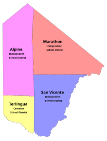
Panther Junction is served by the San Vicente Independent School District, which located its school facility there circa 1951.[6] The district covers most of Big Bend National Park and Southeastern Brewster County.[7] High schoolers zoned to San Vicente ISD attend school in Terlingua Common School District's Big Bend High School.[8]
Previously Alpine High School of the Alpine Independent School District served as the high school for students from San Vicente ISD.[6] In 1996 Big Bend High opened,[9] and San Vicente began sending students to Big Bend High when it was established.[10]
References
- Feature Detail Report for: Panther Junction. USGS. Accessed 2021-04-25
- Highway 385 Panther Junction, Big Bend National Park, TX 79834. Accessed 2021-04-25
- "Panther Junction (in Brewster County, TX) Populated Place Profile". Hometown Locator. 2021-04-25. Retrieved 2021-04-25.
- "NOWData - NOAA Online Weather Data". National Oceanic and Atmospheric Administration. Retrieved June 12, 2021.
- "Summary of Monthly Normals 1991-2020". National Oceanic and Atmospheric Administration. Retrieved June 12, 2021.
- Tucker, Albert Briggs (2008). Ghost Schools of the Big Bend. Howard Payne University Press. p. 26. ISBN 9780615191348.
- "School districts in Brewster County". Texas Education Agency. 2001-03-05. Archived from the original on 2001-03-05. Retrieved 2021-06-16.
- "Jessi Milam". U.S. Department of Education. Retrieved 2021-06-16.
- Pressly, Sue Ann (1997-08-10). "Town's New High School Makes Grade With Students". Los Angeles Times. Retrieved 2021-06-16.
- Trotter, Andrew (1996-09-11). "Take Note". Education Week. Retrieved 2021-06-16.
Municipalities and communities of Brewster County, Texas, United States | ||
|---|---|---|
County seat: Alpine | ||
| City |  | |
| CDPs |
| |
| Other communities | ||
| Ghost towns |
| |
| Annexed former counties | ||
| ||
Другой контент может иметь иную лицензию. Перед использованием материалов сайта WikiSort.org внимательно изучите правила лицензирования конкретных элементов наполнения сайта.
WikiSort.org - проект по пересортировке и дополнению контента Википедии