 Overlook of Rio Grande Village in Big Bend National Park, Texas.
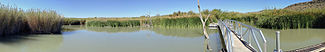 Panoramic view of marsh crossing on the Rio Grande Village Nature Trail
 Panoramic overlook view on the Rio Grande Village Nature Trail in Big Bend National Park, Texas.
world.wikisort.org - USA
Boquillas was a small settlement in Texas, located on the northern banks of the Rio Grande. It was located within Brewster County, 5 miles northeast of San Vicente, Texas.[1] The place existed to service the mining operations at Boquillas del Carmen, Mexico, just across the Rio Grande.
Boquillas, Texas | |
|---|---|
Village | |
 Boquillas in Big Bend | |
| Nickname(s): Rio Grande Village | |
 Boquillas, Texas Location within Texas  Boquillas, Texas Boquillas, Texas (the United States) | |
| Coordinates: 29°10′58″N 102°57′41.5″W | |
| Country | United States |
| State | Texas |
| County | Brewster |
| Elevation | 1,844 ft (562 m) |
| Time zone | UTC-6 (Central (CST)) |
| • Summer (DST) | UTC-5 (CDT) |
| ZIP codes | 79834 |
| Area code | 432 |
| GNIS feature ID | 2034469, 2033923 |
Between 1901 and 1936, María G. Sada ran "Chata's Place" the only store and restaurant in the Boquillas area at that time.
Boquillas, Texas is now in Big Bend National Park. It is now usually known as Rio Grande Village, and consists of a ranger station and other buildings to serve visitors to the park. In 1916, over 200 Villistas raided Boquillas and nearby Glenn Springs, Texas.[2] At Boquillas, the Americans were able to capture one of the raider commanders, but lost two men who were taken captive by the Mexicans.
The Rio Grande border crossing to Boquillas del Carmen was closed in 2002. On January 7, 2011, the U.S. National Park Service announced plans to reopen the crossing.[3] After multiple delays, the unmanned border station was finally opened on April 11, 2013.[4][5][6]
Geographic points of interest
- Chisos Mountains
- Emory Peak
- Mariscal Mine
- Sierra del Carmen
Landscape depictions of Boquillas, Texas


Climate
The Köppen climate classification system categorizes Boquillas as a semiarid climate .
- Coordinates: 29.18528°N 102.96222°W
- Elevation: 1,858 feet (566 m)[7]
| Climate data for Boquillas, Texas (Jun 15, 1910–Sep 30, 2006) | |||||||||||||
|---|---|---|---|---|---|---|---|---|---|---|---|---|---|
| Month | Jan | Feb | Mar | Apr | May | Jun | Jul | Aug | Sep | Oct | Nov | Dec | Year |
| Record high °F (°C) | 92 (33) |
99 (37) |
103 (39) |
112 (44) |
116 (47) |
117 (47) |
116 (47) |
115 (46) |
115 (46) |
105 (41) |
99 (37) |
94 (34) |
117 (47) |
| Average high °F (°C) | 69.8 (21.0) |
75.0 (23.9) |
83.1 (28.4) |
92.0 (33.3) |
99.4 (37.4) |
103.3 (39.6) |
103.6 (39.8) |
101.8 (38.8) |
96.9 (36.1) |
89.1 (31.7) |
77.7 (25.4) |
68.8 (20.4) |
88.4 (31.3) |
| Daily mean °F (°C) | 50.5 (10.3) |
55.6 (13.1) |
63.5 (17.5) |
72.5 (22.5) |
81.3 (27.4) |
87.2 (30.7) |
87.8 (31.0) |
86.6 (30.3) |
81.3 (27.4) |
71.5 (21.9) |
59.3 (15.2) |
50.2 (10.1) |
70.6 (21.4) |
| Average low °F (°C) | 31.5 (−0.3) |
36.4 (2.4) |
44.1 (6.7) |
53.1 (11.7) |
63.4 (17.4) |
71.2 (21.8) |
72.2 (22.3) |
71.3 (21.8) |
65.6 (18.7) |
54.0 (12.2) |
40.9 (4.9) |
31.7 (−0.2) |
52.9 (11.6) |
| Record low °F (°C) | 13 (−11) |
13 (−11) |
14 (−10) |
29 (−2) |
44 (7) |
55 (13) |
59 (15) |
60 (16) |
40 (4) |
24 (−4) |
16 (−9) |
4 (−16) |
4 (−16) |
| Average precipitation inches (mm) | 0.39 (9.9) |
0.37 (9.4) |
0.21 (5.3) |
0.42 (11) |
1.17 (30) |
1.35 (34) |
1.29 (33) |
1.18 (30) |
1.07 (27) |
1.11 (28) |
0.42 (11) |
0.35 (8.9) |
9.34 (237) |
| Average snowfall inches (cm) | 0.0 (0.0) |
0.1 (0.25) |
0.0 (0.0) |
0.0 (0.0) |
0.0 (0.0) |
0.0 (0.0) |
0.0 (0.0) |
0.0 (0.0) |
0.0 (0.0) |
0.0 (0.0) |
0.0 (0.0) |
0.0 (0.0) |
0.1 (0.25) |
| Average precipitation days (≥ 0.01 in) | 3.0 | 2.0 | 2.0 | 2.0 | 4.0 | 5.0 | 6.0 | 5.0 | 4.0 | 4.0 | 2.0 | 2.0 | 41 |
| Source: Western Regional Climate Center, Desert Research Institute[8] | |||||||||||||
References
- "San Vicente, TX". Texas State Historical Association. Archived from the original on August 5, 2014.
- Welsh, Michael (January 2002). "Landscape of Ghosts, River of Dreams: An Administrative History of Big Bend National Park" (PDF). National Park Service. p. 14. Archived from the original (PDF) on May 30, 2010.
- Burnett, John (January 7, 2007). "Big Bend Border Crossing To Reopen". NPR News. Archived from the original on December 3, 2013.
- "In Boquillas, reopened border crossing a welcome sight". Houston Chronicle. April 15, 2013. Archived from the original on January 11, 2014. Retrieved April 18, 2013.
- "Formalizing A Border Crossing At Boquillas". KPBS. January 2, 2013. Archived from the original on February 24, 2013. Retrieved April 18, 2013.
- "Border opening brings life back to Boquillas". My San Antonio. April 13, 2013. Archived from the original on April 19, 2013. Retrieved April 18, 2013.
- "US COOP Station Map". Western Regional Climate Center, Desert Research Institute. Retrieved September 5, 2015.
- "BOQUILLAS, TEXAS (410950), Period of Record Monthly Climate Summary". Western Regional Climate Center, Desert Research Institute. Retrieved September 5, 2015.
External links
Wikimedia Commons has media related to Boquillas, Texas.
- Kohout, Martin Donell. "Boquillas, Tx". TSHA Handbook of Texas Online. Texas State Historical Association.
- Brune, Gunnar. "Boquillas Hot Springs". TSHA Handbook of Texas Online. Texas State Historical Association.
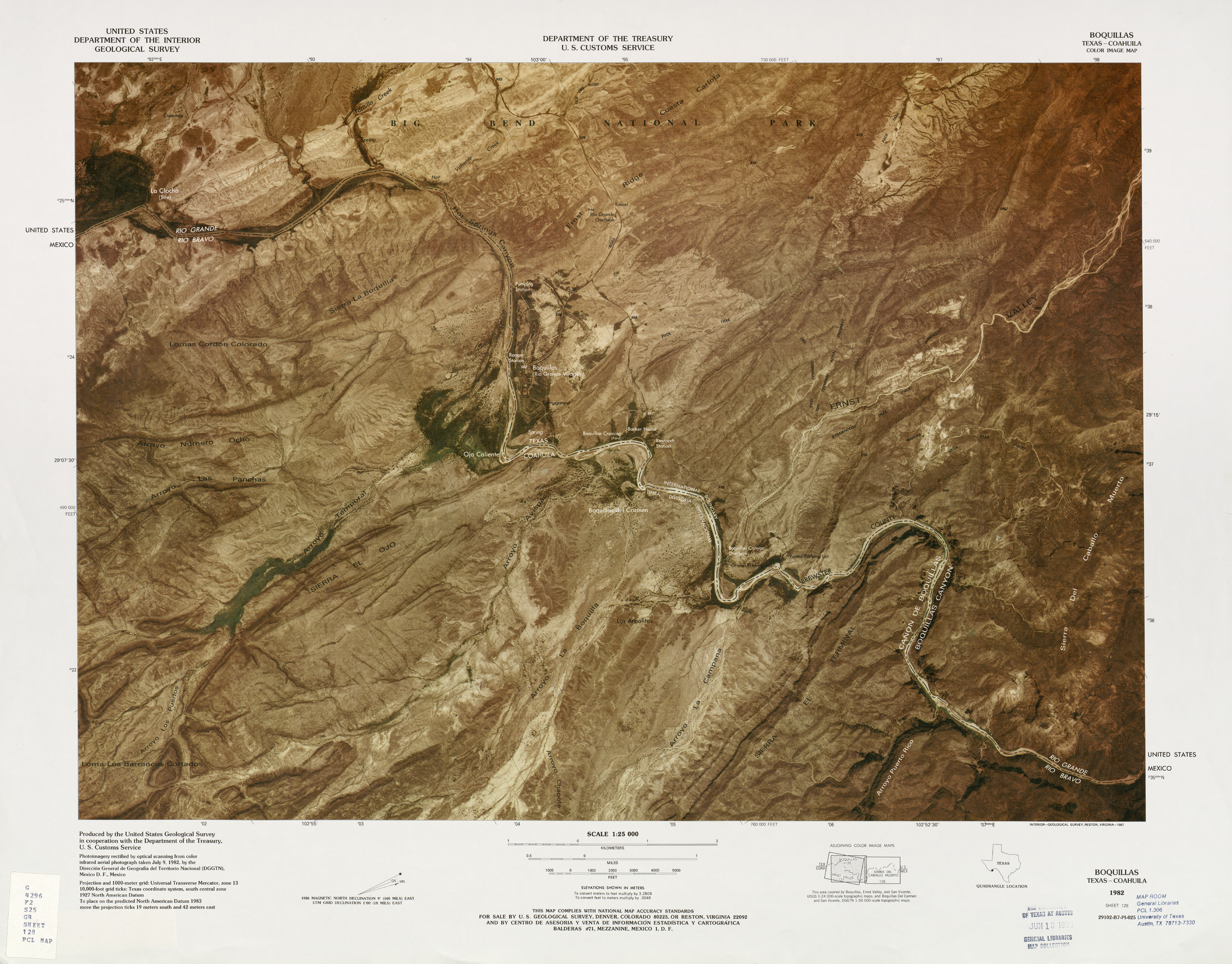
- "Boquillas, Texas - Coahuila, Mexico Aerial Map", Perry-Castañeda Library Map Collection, The University of Texas at Austin
Municipalities and communities of Brewster County, Texas, United States | ||
|---|---|---|
County seat: Alpine | ||
| City |  | |
| CDPs |
| |
| Other communities | ||
| Ghost towns |
| |
| Annexed former counties |
| |
| ||
 | This article about a location in Brewster County, Texas is a stub. You can help Wikipedia by expanding it. |
Текст в блоке "Читать" взят с сайта "Википедия" и доступен по лицензии Creative Commons Attribution-ShareAlike; в отдельных случаях могут действовать дополнительные условия.
Другой контент может иметь иную лицензию. Перед использованием материалов сайта WikiSort.org внимательно изучите правила лицензирования конкретных элементов наполнения сайта.
Другой контент может иметь иную лицензию. Перед использованием материалов сайта WikiSort.org внимательно изучите правила лицензирования конкретных элементов наполнения сайта.
2019-2026
WikiSort.org - проект по пересортировке и дополнению контента Википедии
WikiSort.org - проект по пересортировке и дополнению контента Википедии