world.wikisort.org - USA
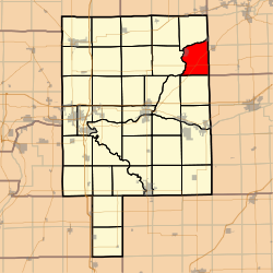
Mission Township is located in LaSalle County, Illinois. As of the 2010 census, its population was 3,972 and it contained 1,083 housing units.[2]
Mission Township | |
|---|---|
Township | |
 Location in LaSalle County | |
 LaSalle County's location in Illinois | |
| Country | United States |
| State | Illinois |
| County | LaSalle |
| Established | November 6, 1849 |
| Area | |
| • Total | 32.06 sq mi (83.0 km2) |
| • Land | 31.63 sq mi (81.9 km2) |
| • Water | 0.42 sq mi (1.1 km2) 1.31% |
| Population (2010) | |
| • Estimate (2016)[1] | 4,488 |
| • Density | 125.6/sq mi (48.5/km2) |
| Time zone | UTC-6 (CST) |
| • Summer (DST) | UTC-5 (CDT) |
| FIPS code | 17-099-49646 |
History
Mission Township was given its name due to the church-riding ministers riding across to different churches in the township. One of these ministers, Jessie Walker, actually has a memorial at the United Methodist Church in Sheridan, which is the seat of the township.
Geography
The township is shares its western boundary with Serena Township, and its northern boundary with Northville Township. The township border is defined by where the Fox River goes southwest, turns south, then continues to go east, south, west, northwest, north, and then it then curves to go southwest again, forming an awkward "S" shape on the map.
The community of Sheridan resides at the beginning of the bends in the river, and the community of Norway resides where the river flows north, and then curves around to flow southwest. Millington resides along the river, northeast of Sheridan. The community of Newark resides along the county line within Kendall County, but the community is no more than 4 to 5 miles away from the river.
According to the 2010 census, the township has a total area of 32.06 square miles (83.0 km2), of which 31.63 square miles (81.9 km2) (or 98.66%) is land and 0.42 square miles (1.1 km2) (or 1.31%) is water.[2]
Notable Locations
- Fox River Resort (Norway), site of timeshare lodging facility, owned by RCI, a division of Wyndham Worldwide.
- Norwegian Memorial (Norway), site of plaques from the Norwegian King commemorating the community's founding in 1834.
- Agricultural Crash Memorial (Norway), site of a crashed plane, which symbolized the sudden and abrupt economic decline in agricultural prices during the 1980s.
- Jessie Walker Memorial (Sheridan), commemorates the court-riding ministers who gave the township its name, the most notable of whom was Jessie Walker. The memorial is along the side of the Sheridan United Methodist Church in town.
- Sheridan Correctional Facility (Sheridan), facility run by the Illinois Department of Corrections for rehabilitation, and is currently rated as a medium-security facility.
- Robert Rowe Public Library (Sheridan), library named for local philanthropist and descendant of one of the community's founding families, houses historical records about the area.
- Norsk Museum (Norway), shows how life was like for the Norwegian settlers in the early years of the community.
- Norway Store (Norway), a family-run store whose distinctive and curious architecture reflects the structures that were in the original community.
- Concept Haulers Speedway (Norway), a go-kart track which is known for having frequent races and tournaments featuring local racers.
- The Old Mill Inn (Sheridan), a former local bar, turned restaurant which is known for its Fried Chicken, Taco Nite, and other local draws.
- The Corner Tap (Sheridan), a local tavern whose claim to be "The Center of The World" is not lost on the locals, and every August, it hosts a Lawn Mower Poker Run and Tractor Pull Competition, which is a big draw.
- Sheridan Veterans Memorial (Sheridan), now complete, and it honors the branches of the military, the town's contributions to every armed conflict, and all who have served.
Demographics
| Historical population | |||
|---|---|---|---|
| Census | Pop. | %± | |
| 2016 (est.) | 4,488 | [1] | |
| U.S. Decennial Census[3] | |||
County Highways
- CH 3 (South of Sheridan) 2603rd Road/Sheridan-Norway Road/Gerald "Jerry" Johnson Highway
- CH 3 (In Sheridan) Robinson Street
- CH 3 (North of Sheridan) 2603rd Road, 4251st Road, 2750th Road/Sheridan Blacktop
- CH 32 N 41st Road/Si Johnson Avenue/Bowen Road
- CH 31 E 30th Road/Millington Road
References
- "Population and Housing Unit Estimates". Retrieved June 9, 2017.
- "Population, Housing Units, Area, and Density: 2010 - County -- County Subdivision and Place -- 2010 Census Summary File 1". United States Census. Archived from the original on 2020-02-12. Retrieved 2013-05-28.
- "Census of Population and Housing". Census.gov. Retrieved June 4, 2016.
External links
Другой контент может иметь иную лицензию. Перед использованием материалов сайта WikiSort.org внимательно изучите правила лицензирования конкретных элементов наполнения сайта.
WikiSort.org - проект по пересортировке и дополнению контента Википедии

