world.wikisort.org - USA
Marengo is a city in McHenry County, Illinois, United States on the Kishwaukee River. It lies approximately 60 miles west northwest of Chicago. Per the 2020 census, the population was 7,568.[3]
Marengo | |
|---|---|
City | |
 Buildings in downtown Marengo. | |
| Motto: Home of Settlers Days | |
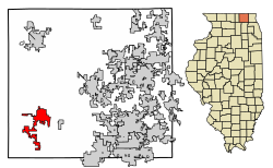 Location of Marengo in McHenry County, Illinois. | |
 Location of Illinois in the United States | |
| Coordinates: 42°15′03″N 88°36′18″W | |
| Country | United States |
| State | Illinois |
| County | McHenry |
| Township | Marengo, Seneca, Coral, Riley |
| Founded | 1835 |
| Government | |
| • Mayor | John Koziol |
| Area | |
| • Total | 8.90 sq mi (23.06 km2) |
| • Land | 8.90 sq mi (23.06 km2) |
| • Water | 0.00 sq mi (0.00 km2) |
| Elevation | 833 ft (254 m) |
| Population (2020) | |
| • Total | 7,568 |
| • Density | 850.15/sq mi (328.25/km2) |
| Time zone | UTC-6 (CST) |
| • Summer (DST) | UTC-5 (CDT) |
| ZIP Code(s) | 60152 |
| Area code | 815 |
| FIPS code | 17-46786 |
| Wikimedia Commons | Marengo, Illinois |
| Website | http://www.cityofmarengo.com/ |
Geography
Marengo is located at 42°15′3″N 88°36′18″W.[4]
The north edge of Marengo is bordered by the Kishwaukee River
According to the 2010 census, Marengo has a total area of 5.01 square miles (12.98 km2), all land.[5]
Major streets
 Grant Highway
 State Street
 Telegraph Street
History
Marengo was first named Pleasant Grove after a grove of trees near the town site.[6] The present name commemorates the Battle of Marengo.[6] A post office named Marengo was established in 1844.[7]
In the early morning of June 11, 2017, at around 4:50 A.M., a house in the northwest suburbs exploded. The gas explosion set four houses on fire and damaged 50 more, nearly 20 of which were deemed "unlivable." Despite the extensive damage, no fatalities or serious injuries occurred; only two people were reported to have suffered minor injuries.[8][9]
Government
Marengo is governed by the mayor, John Koziol, and a city council of eight aldermen.
Demographics
| Historical population | |||
|---|---|---|---|
| Census | Pop. | %± | |
| 1860 | 1,119 | — | |
| 1870 | 1,327 | 18.6% | |
| 1880 | 1,264 | −4.7% | |
| 1890 | 1,445 | 14.3% | |
| 1900 | 2,005 | 38.8% | |
| 1910 | 1,936 | −3.4% | |
| 1920 | 1,758 | −9.2% | |
| 1930 | 1,948 | 10.8% | |
| 1940 | 2,034 | 4.4% | |
| 1950 | 2,726 | 34.0% | |
| 1960 | 3,568 | 30.9% | |
| 1970 | 4,235 | 18.7% | |
| 1980 | 4,361 | 3.0% | |
| 1990 | 4,768 | 9.3% | |
| 2000 | 6,355 | 33.3% | |
| 2010 | 7,648 | 20.3% | |
| 2020 | 7,568 | −1.0% | |
| U.S. Decennial Census[10] 2010[11] 2020[12] | |||
2020 census
| Race / Ethnicity | Pop 2010[11] | Pop 2020[12] | % 2010 | % 2020 |
|---|---|---|---|---|
| White alone (NH) | 6,305 | 5,758 | 82.44% | 76.08% |
| Black or African American alone (NH) | 41 | 94 | 0.54% | 1.24% |
| Native American or Alaska Native alone (NH) | 16 | 20 | 0.21% | 0.26% |
| Asian alone (NH) | 37 | 51 | 0.48% | 0.67% |
| Pacific Islander alone (NH) | 1 | 0 | 0.01% | 0.00% |
| Some Other Race alone (NH) | 7 | 16 | 0.09% | 0.21% |
| Mixed Race/Multi-Racial (NH) | 69 | 248 | 0.90% | 3.28% |
| Hispanic or Latino (any race) | 1,172 | 1,381 | 15.32% | 18.25% |
| Total | 7,648 | 7,568 | 100.00% | 100.00% |
Note: the US Census treats Hispanic/Latino as an ethnic category. This table excludes Latinos from the racial categories and assigns them to a separate category. Hispanics/Latinos can be of any race.
2000 Census
As of the census[13] of 2000, there were 6,355 people, 2,387 households, and 1,694 families residing in the city. The population density was 1,598.5 inhabitants per square mile (617.2/km2). There were 2,475 housing units at an average density of 622.6 per square mile (240.4/km2). The racial makeup of the city was 92.07% White, 0.30% African American, 0.27% Native American, 0.28% Asian, 0.02% Pacific Islander, 5.54% of other races, and 1.53% of two or more races. Hispanic or Latino of any race were 13.00% of the population.
There were 2,387 households, out of which 38.6% had children under the age of 18 living with them, 55.9% were married couples living together, 10.7% had a female householder with no husband present, and 29.0% were non-families. 24.9% of all households were made up of individuals, and 9.8% had someone living alone who was 65 years of age or older. The average household size was 2.64 and the average family size was 3.17.
The population was spread out, with 29.3% under the age of 18, 8.6% from 18 to 24, 31.0% from 25 to 44, 19.2% from 45 to 64, and 12.0% who were 65 years of age or older. The median age was 34 years. For every 100 females, there were 96.3 males. For every 100 females age 18 and over, there were 94.3 males.
The median income for a household in the city was $50,214, and the median income for a family was $57,209. Males had a median income of $41,298 versus $26,317 for females. The per capita income for the city was $22,225. About 3.9% of families and 4.4% of the population were below the poverty line, including 5.4% of those under age 18 and 5.5% of those age 65 or over.
Notable people
- David Boies, lawyer and Chairman of Boies, Schiller & Flexner, and lawyer for Al Gore in Bush v. Gore
- Jack D. Franks, Former Illinois State Representative, Current McHenry County Board Chairman.
- Carl Lundgren, pitcher for the Chicago Cubs (1902–1909); born in Marengo
- Edward D. Shurtleff, Illinois state legislator, jurist; served as mayor of Marengo
- Shane Singh, journalist and former Executive Editor of Playboy magazine
- Sherman E. Smalley, Wisconsin state assemblyman and jurist; born in Marengo
- Carrie Adell Strahorn, American pioneer, explorer, and author
- Egbert Van Alstyne, songwriter
Media
The Marengo-Union Times is the newspaper of record in Marengo, IL. It has a circulation of 6,300 and is mailed to every home and business in the greater Marengo and Union, Illinois area.
References
- "2020 U.S. Gazetteer Files". United States Census Bureau. Retrieved March 15, 2022.
- "USGS detail on Newtown". Retrieved 2007-10-21.
- "Marengo city, Illinois". United States Census Bureau. Retrieved April 15, 2022.
- "US Gazetteer files: 2010, 2000, and 1990". United States Census Bureau. 2011-02-12. Retrieved 2011-04-23.
- "G001 - Geographic Identifiers - 2010 Census Summary File 1". United States Census Bureau. Archived from the original on 2020-02-13. Retrieved 2015-12-27.
- Chicago and North Western Railway Company (1908). A History of the Origin of the Place Names Connected with the Chicago & North Western and Chicago, St. Paul, Minneapolis & Omaha Railways. p. 98.
- "McHenry County". Jim Forte Postal History. Retrieved 22 March 2015.
- Marrazzo, Amanda. "'A miracle' that no one killed during Marengo explosion that set 4 houses ablaze". chicagotribune.com. Retrieved 2018-12-30.
- Rohr, Lauren (2018-06-11). "One year after Marengo neighborhood explosion, families still seeking normalcy". Daily Herald. Retrieved 2018-12-30.
- "Decennial Census of Population and Housing by Decades". US Census Bureau.
- "P2 HISPANIC OR LATINO, AND NOT HISPANIC OR LATINO BY RACE – 2010: DEC Redistricting Data (PL 94-171) – Marengo city, Illinois". United States Census Bureau.
- "P2 HISPANIC OR LATINO, AND NOT HISPANIC OR LATINO BY RACE – 2020: DEC Redistricting Data (PL 94-171) – Marengo city, Illinois". United States Census Bureau.
- "U.S. Census website". United States Census Bureau. Retrieved 2008-01-31.
External links
Municipalities and communities of McHenry County, Illinois, United States | ||
|---|---|---|
County seat: Woodstock | ||
| Cities |  | |
| Villages | ||
| Townships | ||
| CDPs | ||
| Other communities | ||
| Footnotes | ‡This populated place also has portions in an adjacent county or counties | |
| ||
| Major city |  | |
|---|---|---|
| Cities (over 30,000 in 2010) |
| |
| Towns and villages (over 30,000 in 2010) |
| |
| Counties | ||
| Regions |
| |
| Sub-regions |
| |
Illinois, United States | ||
Authority control | |
|---|---|
| General | |
| National libraries | |
| Other |
|
На других языках
- [en] Marengo, Illinois
[ru] Маренго (Иллинойс)
Маренго (англ. Marengo) — город, расположенный в округе Мак-Генри (штат Иллинойс, США) с населением в 6355 человек по статистическим данным переписи 2000 года.Другой контент может иметь иную лицензию. Перед использованием материалов сайта WikiSort.org внимательно изучите правила лицензирования конкретных элементов наполнения сайта.
WikiSort.org - проект по пересортировке и дополнению контента Википедии