world.wikisort.org - USA
Hemlock (originally called Terre Hall[2]) is an unincorporated community in southern Taylor Township, Howard County, Indiana, United States. It lies at the intersection of State Road 26 with County Road 450E.[3]
Hemlock, Indiana | |
|---|---|
Unincorporated community | |
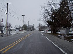
 Along State Road 26 in Hemlock | |
 Hemlock  Hemlock | |
| Coordinates: 40°25′12″N 86°2′29″W | |
| Country | United States |
| State | Indiana |
| County | Howard |
| Township | Taylor |
| Elevation | 860 ft (260 m) |
| ZIP code | 46937 |
| Area code(s) | 765 |
| GNIS feature ID | 436002[1] |
Hemlock is part of the Kokomo, Indiana Metropolitan Statistical Area.
History
Hemlock was laid out in 1852.[4] It was originally known as Terre Halle, but was renamed Hemlock before 1881.[5]
Geography
Hemlock is located at 40°25′12″N 86°2′29″W.
References
- "Hemlock, Indiana". Geographic Names Information System. United States Geological Survey. Retrieved 2009-10-17.
- Geographic Names Information System Feature Detail Report, Geographic Names Information System, 1979-02-14. Accessed 2008-01-07.
- DeLorme. Indiana Atlas & Gazetteer. 3rd ed. Yarmouth: DeLorme, 2004, p. 33. ISBN 0-89933-319-2.
- "Howard County's Townships and Their Early Settlements and Towns". Kokomo-Howard County Public Library. Archived from the original on 22 December 2013. Retrieved 2 June 2014.
- "A Look Back as We Move Forward". The Kokomo Tribune. March 28, 1999. p. 58. Retrieved August 16, 2014 – via Newspapers.com.

Текст в блоке "Читать" взят с сайта "Википедия" и доступен по лицензии Creative Commons Attribution-ShareAlike; в отдельных случаях могут действовать дополнительные условия.
Другой контент может иметь иную лицензию. Перед использованием материалов сайта WikiSort.org внимательно изучите правила лицензирования конкретных элементов наполнения сайта.
Другой контент может иметь иную лицензию. Перед использованием материалов сайта WikiSort.org внимательно изучите правила лицензирования конкретных элементов наполнения сайта.
2019-2025
WikiSort.org - проект по пересортировке и дополнению контента Википедии
WikiSort.org - проект по пересортировке и дополнению контента Википедии
