world.wikisort.org - USA
Phlox is an unincorporated community in southern Union Township, Howard County, Indiana, United States. It lies at the intersection of State Road 26 with County Road 1100 East.[2]
Phlox, Indiana | |
|---|---|
Unincorporated community | |
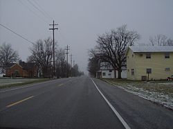
 Along State Road 26 in Phlox | |
 Phlox  Phlox | |
| Coordinates: 40°25′16″N 85°55′7″W | |
| Country | United States |
| State | Indiana |
| County | Howard |
| Township | Union |
| Elevation | 850 ft (260 m) |
| GNIS feature ID | 441096 |
Phlox is part of the Kokomo, Indiana Metropolitan Statistical Area.
Phlox is probably named after the local vegetation.[3]
Geography
Phlox is located at 40°25′16″N 85°55′7″W.
References
- "US Board on Geographic Names". United States Geological Survey. 2007-10-25. Retrieved 2008-01-31.
- DeLorme. Indiana Atlas & Gazetteer. 3rd ed. Yarmouth: DeLorme, 2004, p. 33. ISBN 0-89933-319-2.
- "A Look Back as We Move Forward". The Kokomo Tribune. March 28, 1999. p. 58. Retrieved August 16, 2014 – via Newspapers.com.

Текст в блоке "Читать" взят с сайта "Википедия" и доступен по лицензии Creative Commons Attribution-ShareAlike; в отдельных случаях могут действовать дополнительные условия.
Другой контент может иметь иную лицензию. Перед использованием материалов сайта WikiSort.org внимательно изучите правила лицензирования конкретных элементов наполнения сайта.
Другой контент может иметь иную лицензию. Перед использованием материалов сайта WikiSort.org внимательно изучите правила лицензирования конкретных элементов наполнения сайта.
2019-2025
WikiSort.org - проект по пересортировке и дополнению контента Википедии
WikiSort.org - проект по пересортировке и дополнению контента Википедии
