world.wikisort.org - USA
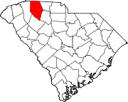
Fairforest is a Census-designated place located in Spartanburg County in the U.S. State of South Carolina.[4] According to the 2010 United States Census, the population was 1,693.[5]
Fairforest | |
|---|---|
CDP | |
 Fairforest Location within the state of South Carolina | |
| Coordinates: 34°56′49″N 82°01′08″W | |
| Country | United States |
| State | South Carolina |
| County | Spartanburg |
| Area | |
| • Total | 2.10 sq mi (5.43 km2) |
| • Land | 2.09 sq mi (5.42 km2) |
| • Water | 0.01 sq mi (0.01 km2) |
| Elevation | 846 ft (258 m) |
| Population (2020)[3] | |
| • Total | 1,646 |
| • Density | 786.81/sq mi (303.84/km2) |
| Time zone | UTC-5 (Eastern (EST)) |
| • Summer (DST) | UTC-4 (EDT) |
| ZIP codes | 29301 |
| FIPS code | 45083 |
| GNIS feature ID | 2629825[2] |
History
During the Revolution, Fairforest was one of the only regions in South Carolina where Loyalists outnumbered Patriots. It was described as a "hot-bed of pro-British sentiment."[6] A post office was established as Fair Forest in 1884.[7] According to tradition, a pioneer named the region when, noting the scenery, he said "What a fair forest!"[8]
Geography
Fairforest is located at 34°56′49″N 82°01′08″W (34.946963, -82.018906).[4] The CDP is a suburb of the City of Spartanburg, located to the West of the city, alongside Arcadia and Saxon.
According to the United States Census Bureau, the CDP has a total land area of 5.416 square miles (3.973 km2) and a total water area of 0.006 square miles (0.016 km2).[4]
Demographics
| Historical population | |||
|---|---|---|---|
| Census | Pop. | %± | |
| 2020 | 1,646 | — | |
| U.S. Decennial Census[9] | |||
Education
It is in Spartanburg County School District 6.[10]
References
- "ArcGIS REST Services Directory". United States Census Bureau. Retrieved October 15, 2022.
- U.S. Geological Survey Geographic Names Information System: Fairforest, South Carolina
- "Census Population API". United States Census Bureau. Retrieved Oct 15, 2022.
- "US Gazetteer files: 2010, 2000, and 1990". United States Census Bureau. 2011-02-12. Retrieved 2011-04-23.
- Source: 2010 Census results for Fairforest, SC Archived 2012-06-16 at the Wayback Machine
- "Nehemiah Howard and His Family". 1983.
- "Spartanburg County". Jim Forte Postal History. Archived from the original on 19 January 2016. Retrieved 22 April 2015.
- Lake, William C. (22 June 1935). "Names of Union Streams Have Interesting History". Spartanburg Herald-Journal. pp. A1. Retrieved 22 April 2015.
- "Census of Population and Housing". Census.gov. Retrieved June 4, 2016.
- "2020 CENSUS - SCHOOL DISTRICT REFERENCE MAP: Spartanburg County, SC" (PDF). U.S. Census Bureau. Retrieved 2021-07-05.
Другой контент может иметь иную лицензию. Перед использованием материалов сайта WikiSort.org внимательно изучите правила лицензирования конкретных элементов наполнения сайта.
WikiSort.org - проект по пересортировке и дополнению контента Википедии
