world.wikisort.org - USA
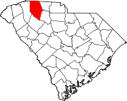
Clifton is a Census-designated place located in Spartanburg County in the U.S. State of South Carolina.[4] According to the 2010 United States Census, the population was 541.[5]
Clifton | |
|---|---|
CDP | |
 Clifton Location within the state of South Carolina | |
| Coordinates: 34°59′10″N 81°49′13″W | |
| Country | United States |
| State | South Carolina |
| County | Spartanburg |
| Area | |
| • Total | 1.14 sq mi (2.95 km2) |
| • Land | 1.07 sq mi (2.78 km2) |
| • Water | 0.07 sq mi (0.17 km2) |
| Elevation | 669 ft (204 m) |
| Population (2020)[3] | |
| • Total | 544 |
| • Density | 506.99/sq mi (195.80/km2) |
| Time zone | UTC-5 (Eastern (EST)) |
| • Summer (DST) | UTC-4 (EDT) |
| ZIP codes | 29324 |
| FIPS code | 45083 |
| GNIS feature ID | 2629821[2] |
Geography
Clifton is located at 34°59′10″N 81°49′13″W (34.986051, -81.820395).[4] These coordinates place the CDP on the East side of the county, between the cities of Spartanburg and Cowpens.
According to the United States Census Bureau, the CDP has a total land area of 1.073 square miles (2.946 km2) and a total water area of 0.065 square mile (0.168 km2).[4]
Demographics
| Historical population | |||
|---|---|---|---|
| Census | Pop. | %± | |
| 2020 | 544 | — | |
| U.S. Decennial Census[6] | |||
References
- "ArcGIS REST Services Directory". United States Census Bureau. Retrieved October 15, 2022.
- U.S. Geological Survey Geographic Names Information System: Clifton, South Carolina
- "Census Population API". United States Census Bureau. Retrieved Oct 15, 2022.
- "US Gazetteer files: 2010, 2000, and 1990". United States Census Bureau. 2011-02-12. Retrieved 2011-04-23.
- See "U.S. Census website". United States Census Bureau. Retrieved 2008-01-31. for population numbers and for municipality and CDP lists in the 2010 Census.
- "Census of Population and Housing". Census.gov. Retrieved June 4, 2016.
Текст в блоке "Читать" взят с сайта "Википедия" и доступен по лицензии Creative Commons Attribution-ShareAlike; в отдельных случаях могут действовать дополнительные условия.
Другой контент может иметь иную лицензию. Перед использованием материалов сайта WikiSort.org внимательно изучите правила лицензирования конкретных элементов наполнения сайта.
Другой контент может иметь иную лицензию. Перед использованием материалов сайта WikiSort.org внимательно изучите правила лицензирования конкретных элементов наполнения сайта.
2019-2025
WikiSort.org - проект по пересортировке и дополнению контента Википедии
WikiSort.org - проект по пересортировке и дополнению контента Википедии
