world.wikisort.org - USA
Dillon is a city in and the county seat of Beaverhead County, Montana, United States.[3] The population was 3,880 at the 2020 census.[4] The city was named for Sidney Dillon (1822–1892), president of Union Pacific Railroad.[5]
Dillon | |
|---|---|
City | |
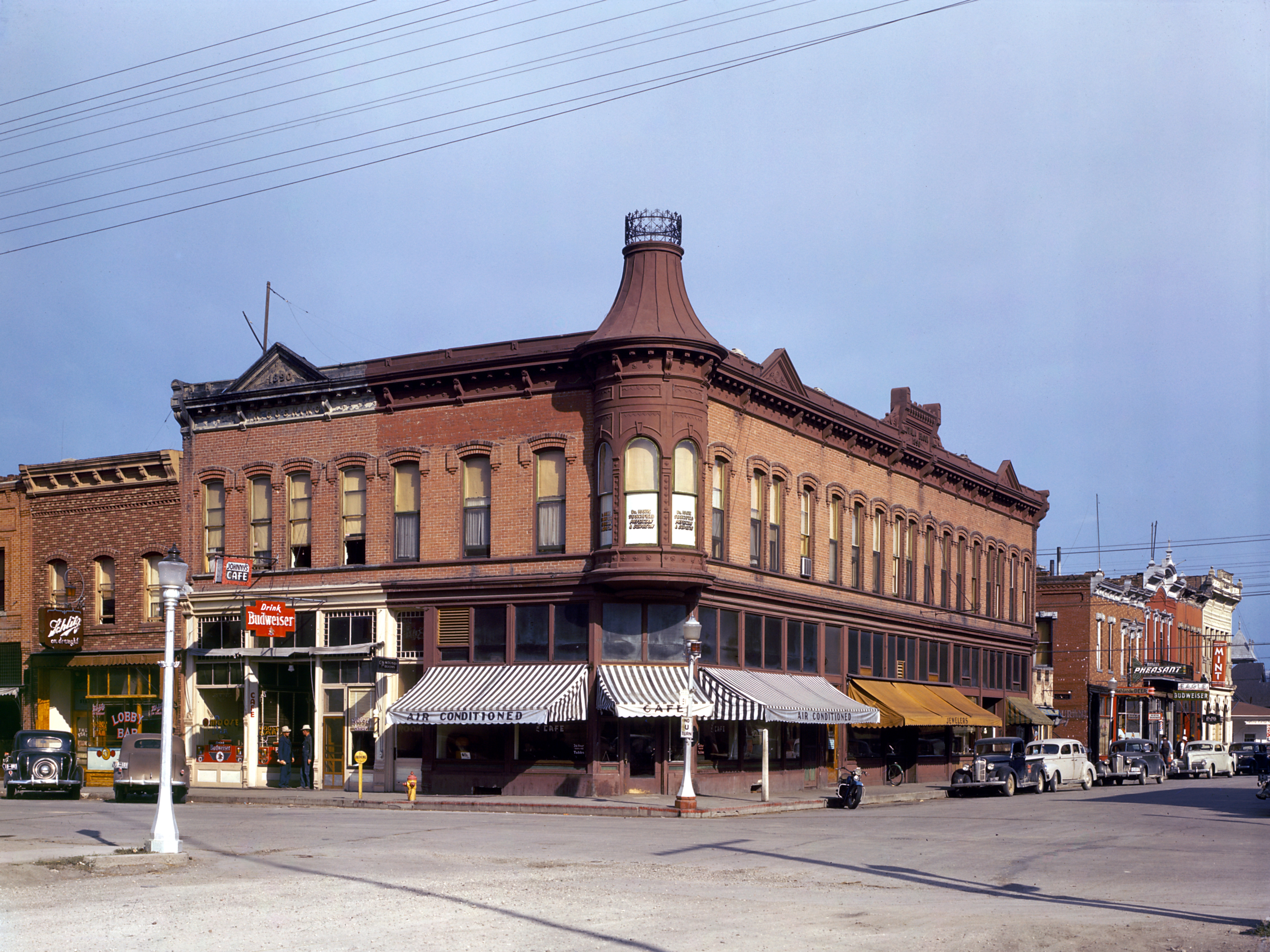
 Business District of Dillon | |
 Location of Dillon, Montana | |
| Coordinates: 45°12′57″N 112°38′3″W | |
| Country | United States |
| State | Montana |
| County | Beaverhead |
| Area | |
| • Total | 1.90 sq mi (4.92 km2) |
| • Land | 1.90 sq mi (4.92 km2) |
| • Water | 0.00 sq mi (0.00 km2) |
| Elevation | 5,240 ft (1,600 m) |
| Population (2020) | |
| • Total | 3,880 |
| • Density | 2,044.26/sq mi (789.25/km2) |
| Time zone | UTC−7 (Mountain (MST)) |
| • Summer (DST) | UTC−6 (MDT) |
| ZIP code | 59725 |
| Area code | 406 |
| FIPS code | 30-20800 |
| GNIS feature ID | 0770653[2] |
| Website | www.dillonmt.org |
History
Dillon was founded in the Beaverhead Valley as a railroad town in 1880. Originally named “Terminus” as it was temporarily the northernmost stop on the Utah and Northern Railway while it was under construction, in 1881, the community was renamed for Union Pacific Railroad President Sidney Dillon, who had directed the project of bringing the railroad through to Butte, Montana. [6] The town's location was selected by the railroad in part because of its proximity to gold mines in the area.[7]
The first ore discovered in the Dillon area was silver. Gold was first discovered at Grasshopper Creek in 1862, precipitating a flood of immigration to the area.[8] The last real gold rush in the area occurred near Argenta in 1920 and lasted for 30 years.
Dillon served as a central location for transporting goods to nearby boomtowns such as Bannack, Argenta, Glen, and Virginia City. In 1881, Dillon became part of a contentious battle with Bannack to become the county seat of Beaverhead County. The first brick building in Dillon was built in 1882. In 1884, Dillon became an incorporated town and began building sidewalks and permanent dwellings for the residents.
While many of the gold mining towns around Dillon died, Dillon was able to thrive due to the railroad and talc mining in the area.[7] A cattle industry was established in 1865. The agriculturally rich Beaverhead Valley became an ideal location for sheep ranching, introduced in 1869.[9] Dillon was once the largest exporter of sheep wool in Montana.
The Montana Normal College was established as a teaching college in 1892, and is still functioning today, renowned for its Education program.[10] A circus elephant named Old Pitt was struck by lightning in 1943 and is buried at the Dillon fairgrounds.[11] Captain Joel Rude of the Montana National Guard crashed his F-106 into a grain elevator and died during a Labor Day Parade on September 3, 1979. A plaque in his honor is part of the Southwest Montana Veterans Memorial park in Dillon.[12]
Geography

Dillon is located at 45°12′57″N 112°38′3″W (45.215735, -112.634055),[13] approximately 40 miles (64 km) east of the Continental Divide.[citation needed] It lies at an elevation of 5,102 feet (1,555 m).[14]
According to the United States Census Bureau, the city has a total area of 1.76 square miles (4.56 km2), all land.[15] Dillon is situated on the Beaverhead River.
Demographics
| Historical population | |||
|---|---|---|---|
| Census | Pop. | %± | |
| 1890 | 1,012 | — | |
| 1900 | 1,530 | 51.2% | |
| 1910 | 1,835 | 19.9% | |
| 1920 | 2,701 | 47.2% | |
| 1930 | 2,422 | −10.3% | |
| 1940 | 3,014 | 24.4% | |
| 1950 | 3,268 | 8.4% | |
| 1960 | 3,690 | 12.9% | |
| 1970 | 4,548 | 23.3% | |
| 1980 | 3,976 | −12.6% | |
| 1990 | 3,991 | 0.4% | |
| 2000 | 3,752 | −6.0% | |
| 2010 | 4,134 | 10.2% | |
| 2020 | 3,880 | −6.1% | |
| U.S. Decennial Census[16][4] | |||
In April 2010, Dillon was listed as one of "America's Prettiest Towns" by Forbes magazine.
2010 census
As of the 2010 census,[17] there were 4,134 people, 1,774 households, and 897 families living in the city. The population density was 2,348.9 inhabitants per square mile (906.9/km2). There were 1,930 housing units at an average density of 1,096.6 per square mile (423.4/km2). The racial makeup of the city was 94.7% White, 0.3% African American, 1.4% Native American, 0.5% Asian, 0.6% Pacific Islander, 0.6% from other races, and 1.9% from two or more races. Hispanic or Latino of any race were 3.5% of the population.
There were 1,774 households, of which 23.0% had children under the age of 18 living with them, 38.2% were married couples living together, 9.1% had a female householder with no husband present, 3.3% had a male householder with no wife present, and 49.4% were non-families. 40.1% of all households were made up of individuals, and 15.9% had someone living alone who was 65 years of age or older. The average household size was 2.08 and the average family size was 2.82.
The median age in the city was 33.9 years. 20% of residents were under the age of 18; 19.4% were between the ages of 18 and 24; 20.3% were from 25 to 44; 23.7% were from 45 to 64; and 16.7% were 65 years of age or older. The gender makeup of the city was 49.4% male and 50.6% female.
2000 census
As of the 2000 census,[18] there were 3,752 people, 1,669 households, and 934 families living in the city. The population density was 2,300.7 people per square mile (888.7/km2). There were 1,831 housing units at an average density of 1,122.7 per square mile (433.7/km2). The racial makeup of the city was 96.43% White, 0.35% African American, 1.31% Native American, 0.13% Asian, 0.61% from other races, and 1.17% from two or more races. Hispanic or Latino of any race were 1.95% of the population.
There were 1,669 households, out of which 27.6% had children under the age of 18 living with them, 44.3% were married couples living together, 8.3% had a female householder with no husband present, and 44.0% were non-families. 36.2% of all households were made up of individuals, and 14.9% had someone living alone who was 65 years of age or older. The average household size was 2.19 and the average family size was 2.88.
In the city, the population was spread out, with 22.7% under the age of 18, 11.1% from 18 to 24, 25.5% from 25 to 44, 22.4% from 45 to 64, and 18.3% who were 65 years of age or older. The median age was 39 years. For every 100 females there were 97.5 males. For every 100 females age 18 and over, there were 94.6 males.
The median income for a household in the city was $26,389, and the median income for a family was $39,643. Males had a median income of $25,625 versus $18,906 for females. The per capita income for the city was $16,432. About 13.8% of families and 18.2% of the population were below the poverty line, including 15.9% of those under age 18 and 15.9% of those age 65 or over.
Media
KDBM AM 1490 and KBEV-FM 98.3, owned by the Dead-Air Broadcasting Company, are both licensed to serve the Dillon area.[19][20] KDWG FM 90.9 is operated by the University of Montana Western.[21] K219DN is a local translator for KUFM (FM), University of Montana Public Radio.
Television stations come from Butte and Denver:
- KXLF (Channel 4) CBS affiliate
- KDVR (Channel 5) Fox Affiliate
- KTVM (Channel 6) NBC affiliate
- KUSM (Channel 9) PBS affiliate
Dillon has two primary newspapers:
- The Dillonite Daily includes sections such as new job listings in and around the area, any and all things for sale, ISO, recent activity, and upcoming events.
- The Dillon Tribune presents sports, obituaries, community news, classifieds, weather and a local calendar.
Education
Dillon is part of School District 10 under Superintendent Glen A. Johnson. Schools in this district include: Parkview Elementary School, under Principal Greg Fitzgerald, and the Dillon Middle School under Principal Randy Shipman.[22] Dillon is also home to Beaverhead County High School, a Class A High School under Principal Gary Haverfield. As of 2017, there were around 320 students. The high school's mascot is the Beaver.[23]
Dillon is known statewide for its decades of success in high school sports. The boys' basketball team won the Class A State Championship in 1990, the school's first state title since 1946. Since 2000 the high school football team has played in 11 Class A State Championships, winning eight. The boys' basketball team has played in eight Class A State Championships since 2007, winning five.
The city is also home to the University of Montana Western, formerly Western Montana College, under provost and vice chancellor Deborah Hedeen and Chancellor Beth Weatherby. As of 2016, there were 1,501 students. The college mascot is the Bulldog.[24]
Dillon Public Library was built as a Carnegie library in 1901 and still serves the community.[25]
Economy
Dillon's largest employers include Barretts Minerals Inc., Barrett Hospital and HealthCare, and Beaverhead County. Great Harvest Bread Company has its franchising headquarters in Dillon. Patagonia has an outlet in Dillon.
Dillon has 31 restaurants,[26] including local businesses such as Papa T's Family Dining, Sparky's Garage, Stageline Pizza, the Lion's Den, 4 B's Restaurant, Sweetwater Coffee, La Fiesta Mexicana, and Mac's Last Cast. The Beaverhead Brewing Company is also in Dillon.[27] Fast food chains with locations in Dillon include Dairy Queen, McDonald's, Subway, Pita Pit, Taco John's, and Pizza Hut. Chain stores in Dillon are Safeway, Town & Country, Ace Hardware, and Murdoch's Ranch & Home Supply.
The Beaverhead County Museum[28] is in Dillon. Public facilities in Dillon include the Dillon Public Library, Post Office, and Barrett's Park. The YMCA has a location within the city limits.[29]
Recreational activities that draw tourism to Dillon include fishing on the Beaverhead River, snowmobiling, hiking, shopping at the Patagonia outlet, four-wheeling, the annual Demolition Derby, and skiing at Maverick Mountain Ski Area. Bannack State Park is popular with tourists. Dillon is also home to the annual "Montana's Biggest Weekend" event, also known as the Jaycee Labor Day Rodeo, Concert, & Parade.[30]
Infrastructure
Dillon Airport is a county-owned airport five miles northeast of Dillon.
Climate
Dillon experiences a semi-arid climate (Köppen BSk) with cold, dry winters and hot, wetter summers.
| Climate data for Dillon, Montana (University of Montana Western), 1991–2020 normals, extremes 1895–present | |||||||||||||
|---|---|---|---|---|---|---|---|---|---|---|---|---|---|
| Month | Jan | Feb | Mar | Apr | May | Jun | Jul | Aug | Sep | Oct | Nov | Dec | Year |
| Record high °F (°C) | 60 (16) |
65 (18) |
74 (23) |
84 (29) |
91 (33) |
98 (37) |
102 (39) |
100 (38) |
94 (34) |
86 (30) |
79 (26) |
65 (18) |
102 (39) |
| Mean maximum °F (°C) | 49.2 (9.6) |
52.4 (11.3) |
63.7 (17.6) |
73.0 (22.8) |
81.4 (27.4) |
88.5 (31.4) |
93.8 (34.3) |
92.0 (33.3) |
87.1 (30.6) |
75.8 (24.3) |
61.2 (16.2) |
48.5 (9.2) |
94.6 (34.8) |
| Average high °F (°C) | 33.3 (0.7) |
36.7 (2.6) |
45.9 (7.7) |
54.3 (12.4) |
64.4 (18.0) |
72.8 (22.7) |
82.9 (28.3) |
80.9 (27.2) |
70.8 (21.6) |
56.4 (13.6) |
41.3 (5.2) |
31.6 (−0.2) |
55.9 (13.3) |
| Daily mean °F (°C) | 23.9 (−4.5) |
26.3 (−3.2) |
34.2 (1.2) |
41.3 (5.2) |
50.3 (10.2) |
57.5 (14.2) |
65.2 (18.4) |
63.2 (17.3) |
55.1 (12.8) |
43.3 (6.3) |
31.1 (−0.5) |
22.4 (−5.3) |
42.8 (6.0) |
| Average low °F (°C) | 14.5 (−9.7) |
15.8 (−9.0) |
22.5 (−5.3) |
28.4 (−2.0) |
36.1 (2.3) |
42.2 (5.7) |
47.6 (8.7) |
45.5 (7.5) |
39.3 (4.1) |
30.3 (−0.9) |
21.0 (−6.1) |
13.2 (−10.4) |
29.7 (−1.3) |
| Mean minimum °F (°C) | −11.0 (−23.9) |
−5.8 (−21.0) |
3.3 (−15.9) |
15.6 (−9.1) |
23.5 (−4.7) |
32.1 (0.1) |
38.9 (3.8) |
36.6 (2.6) |
26.4 (−3.1) |
12.1 (−11.1) |
−2.0 (−18.9) |
−8.7 (−22.6) |
−18.9 (−28.3) |
| Record low °F (°C) | −36 (−38) |
−40 (−40) |
−26 (−32) |
−3 (−19) |
15 (−9) |
23 (−5) |
30 (−1) |
25 (−4) |
9 (−13) |
−13 (−25) |
−31 (−35) |
−37 (−38) |
−40 (−40) |
| Average precipitation inches (mm) | 0.31 (7.9) |
0.35 (8.9) |
0.67 (17) |
1.51 (38) |
1.93 (49) |
1.92 (49) |
0.91 (23) |
0.86 (22) |
0.89 (23) |
0.95 (24) |
0.52 (13) |
0.45 (11) |
11.27 (285.8) |
| Average snowfall inches (cm) | 1.7 (4.3) |
0.9 (2.3) |
0.4 (1.0) |
0.2 (0.51) |
0.1 (0.25) |
0.0 (0.0) |
0.0 (0.0) |
0.0 (0.0) |
0.0 (0.0) |
0.4 (1.0) |
2.9 (7.4) |
4.6 (12) |
11.2 (28.76) |
| Average precipitation days (≥ 0.01 in) | 4.0 | 4.7 | 5.7 | 8.8 | 10.5 | 9.8 | 6.0 | 6.0 | 5.1 | 6.7 | 5.1 | 5.1 | 77.5 |
| Average snowy days (≥ 0.1 in) | 0.9 | 1.0 | 0.7 | 0.2 | 0.0 | 0.0 | 0.0 | 0.0 | 0.1 | 0.2 | 1.0 | 2.0 | 6.1 |
| Source 1: NOAA [31] | |||||||||||||
| Source 2: National Weather Service [32] | |||||||||||||
| Climate data for Dillon, Montana (Dillon Airport), 1991–2020 normals, extremes 1940–present | |||||||||||||
|---|---|---|---|---|---|---|---|---|---|---|---|---|---|
| Month | Jan | Feb | Mar | Apr | May | Jun | Jul | Aug | Sep | Oct | Nov | Dec | Year |
| Record high °F (°C) | 58 (14) |
64 (18) |
79 (26) |
85 (29) |
90 (32) |
98 (37) |
102 (39) |
102 (39) |
97 (36) |
86 (30) |
71 (22) |
62 (17) |
102 (39) |
| Mean maximum °F (°C) | 48.0 (8.9) |
51.9 (11.1) |
62.8 (17.1) |
72.8 (22.7) |
81.0 (27.2) |
87.4 (30.8) |
94.0 (34.4) |
93.1 (33.9) |
88.0 (31.1) |
75.8 (24.3) |
61.4 (16.3) |
47.8 (8.8) |
95.0 (35.0) |
| Average high °F (°C) | 31.7 (−0.2) |
35.2 (1.8) |
45.0 (7.2) |
52.6 (11.4) |
62.4 (16.9) |
70.8 (21.6) |
82.0 (27.8) |
80.6 (27.0) |
70.0 (21.1) |
55.3 (12.9) |
40.6 (4.8) |
30.6 (−0.8) |
54.7 (12.6) |
| Daily mean °F (°C) | 22.3 (−5.4) |
24.5 (−4.2) |
33.2 (0.7) |
40.1 (4.5) |
49.0 (9.4) |
56.6 (13.7) |
64.9 (18.3) |
63.4 (17.4) |
54.7 (12.6) |
42.2 (5.7) |
29.9 (−1.2) |
21.1 (−6.1) |
41.8 (5.5) |
| Average low °F (°C) | 12.9 (−10.6) |
13.8 (−10.1) |
21.4 (−5.9) |
27.6 (−2.4) |
35.6 (2.0) |
42.3 (5.7) |
47.8 (8.8) |
46.2 (7.9) |
39.3 (4.1) |
29.1 (−1.6) |
19.1 (−7.2) |
11.5 (−11.4) |
28.9 (−1.7) |
| Mean minimum °F (°C) | −8.9 (−22.7) |
−3.9 (−19.9) |
4.6 (−15.2) |
15.9 (−8.9) |
23.8 (−4.6) |
33.4 (0.8) |
40.3 (4.6) |
38.7 (3.7) |
28.0 (−2.2) |
12.2 (−11.0) |
−2.0 (−18.9) |
−9.6 (−23.1) |
−17.6 (−27.6) |
| Record low °F (°C) | −33 (−36) |
−43 (−42) |
−23 (−31) |
−5 (−21) |
14 (−10) |
25 (−4) |
32 (0) |
30 (−1) |
10 (−12) |
−9 (−23) |
−29 (−34) |
−37 (−38) |
−43 (−42) |
| Average precipitation inches (mm) | 0.20 (5.1) |
0.24 (6.1) |
0.52 (13) |
1.18 (30) |
1.76 (45) |
1.91 (49) |
0.89 (23) |
0.87 (22) |
0.91 (23) |
0.72 (18) |
0.37 (9.4) |
0.26 (6.6) |
9.83 (250.2) |
| Average precipitation days (≥ 0.01 in) | 3.2 | 4.7 | 6.5 | 9.0 | 11.0 | 10.6 | 6.4 | 6.5 | 6.0 | 5.9 | 5.3 | 4.7 | 79.8 |
| Source 1: NOAA [33] | |||||||||||||
| Source 2: National Weather Service [32] | |||||||||||||
Notable people
- Troy Andersen, NFL linebacker
- Ed Barker, NFL wide receiver
- Lloyd Meeds, politician, lobbyist, and navy officer
- Edwin L. Norris, 5th Governor of Montana (1908–1913)[34]
- Jacob Thorkelson, United States Representative from Montana[35]
- Benjamin F. White, former mayor of Dillon and last Governor of Montana Territory (1889)
See also
- List of municipalities in Montana
References
- "ArcGIS REST Services Directory". United States Census Bureau. Retrieved September 5, 2022.
- U.S. Geological Survey Geographic Names Information System: Dillon, Montana
- "Find a County". National Association of Counties. Archived from the original on 2011-05-31. Retrieved 2011-06-07.
- "U.S. Census website". United States Census Bureau. Retrieved November 2, 2021.
- Gannett, Henry (1905). The Origin of Certain Place Names in the United States. Govt. Print. Off. pp. 106.
- "Dillon | Montana, United States". Encyclopedia Britannica. Retrieved 5 November 2021.
- "Dillon History". Beaverhead County Museum. Beaverhead County Museum. Archived from the original on 17 September 2015. Retrieved 2 February 2015.
- "Archives". Mining History Association. Retrieved 2 February 2015.
- "Welcome to Dillon Montana".
- "Dillon (Southwest Montana)". TravelMT. TravelMT. Retrieved 2 February 2015.
- "Old Pitt, Elephant Killed by Lightning, Dillon, Montana".
- "CAPTAIN JOEL RUDE, Dillon, MT - Specific Veteran Memorials on Waymarking.com".
- "US Gazetteer files: 2010, 2000, and 1990". United States Census Bureau. 2011-02-12. Retrieved 2011-04-23.
- U.S. Geological Survey Geographic Names Information System: Dillon, Montana
- "US Gazetteer files 2010". United States Census Bureau. Archived from the original on 2012-07-02. Retrieved 2012-12-18.
- "Census of Population and Housing". Census.gov. Retrieved June 4, 2015.
- "U.S. Census website". United States Census Bureau. Retrieved 2012-12-18.
- "U.S. Census website". United States Census Bureau. Retrieved 2008-01-31.
- "KDBM-AM 1490 kHz Radio Station Information". Radio-Locator Home Page. Retrieved 17 May 2017.
- "KBEV-FM 98.3 MHz Radio Station Information". Radio-Locator Home Page. Retrieved 17 May 2017.
- "KDWG-FM 90.9 MHz Radio Station Information". Radio-Locator Home Page. Retrieved 17 May 2017.
- "Dillon Middle School". Dillon Middle School. Retrieved 3 February 2015.
- "Beaverhead County High School". Beaverhead County High School. Schoolwires.Com. Retrieved 3 February 2015.
- "UMW Homepage". University of Montana Western. Retrieved 3 February 2015.
- "Dillon Public Library". Retrieved 12 April 2021.
- "Best Restaurantsin Dillon, MT". TripAdvisor. Retrieved 4 February 2015.
- "Beaverhead Brewing Company Homepage". Beaverhead Brewing Company. Retrieved 4 February 2015.
- "Beaverhead County Museum". Beaverhead County Museum. Retrieved 4 February 2015.
- "SouthWestern Montana Family YMCA". SouthWestern Montana Family YMCA. Archived from the original on 4 February 2015. Retrieved 4 February 2015.
- "Montana's Biggest Weekend". VisitMT.Com. Retrieved 4 February 2015.
- "U.S. Climate Normals Quick Access". National Oceanic and Atmospheric Administration. Retrieved on September 4, 2022.
- "NOAA Online Weather Data". National Weather Service. Retrieved on September 4, 2022
- "U.S. Climate Normals Quick Access". National Oceanic and Atmospheric Administration. Retrieved on September 4, 2022.
- "Edwin L. Norris". National Governors Association. Retrieved 14 October 2012.
- "THORKELSON, Jacob, (1876 - 1945)". Biographical Directory of the United States Congress. Retrieved October 14, 2012.
External links
Municipalities and communities of Beaverhead County, Montana, United States | ||
|---|---|---|
County seat: Dillon | ||
| City |  | |
| Town | ||
| CDPs |
| |
| Other communities | ||
| Ghost towns |
| |
| ||
Authority control | |
|---|---|
| General | |
| National libraries | |
| Other | |
На других языках
- [en] Dillon, Montana
[ru] Диллон (Монтана)
Диллон (англ. Dillon, Montana) — город и окружной центр, расположенный в округе Биверхед (штат Монтана, США) с населением в 4 134 человека по статистическим данным переписи 2010 года. Крупнейший населённый пункт в округе Биверхед.Другой контент может иметь иную лицензию. Перед использованием материалов сайта WikiSort.org внимательно изучите правила лицензирования конкретных элементов наполнения сайта.
WikiSort.org - проект по пересортировке и дополнению контента Википедии