world.wikisort.org - United_Kingdom
Dersingham is a village, civil parish and electoral ward in the English county of Norfolk. It is situated some 12 kilometres (7.5 mi) north of the town of King's Lynn and 70 km (43 mi) north-west of the city of Norwich, opening onto The Wash.[1]

| Dersingham | |
|---|---|
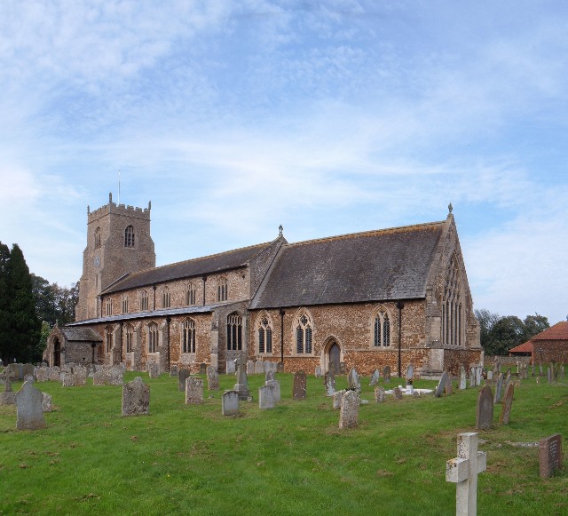 St Nicholas's Church, Dersingham | |
 Dersingham Location within Norfolk | |
| Area | 14.50 km2 (5.60 sq mi) |
| Population | 4,640 (2011) |
| • Density | 320/km2 (830/sq mi) |
| OS grid reference | TF 686 304 |
| Civil parish |
|
| District |
|
| Shire county |
|
| Region |
|
| Country | England |
| Sovereign state | United Kingdom |
| Post town | KING'S LYNN |
| Postcode district | PE31 |
| Police | Norfolk |
| Fire | Norfolk |
| Ambulance | East of England |
| UK Parliament |
|
The villages name means 'Homestead/village of Deorsige's people'.
The civil parish has an area of 14.5 km2 (5.6 sq mi) and in the 2001 census had a population of 4,502 in 2,110 households, the population increasing to 4,640 at the 2011 Census.[2] For the purposes of local government, the parish falls within the district of King's Lynn and West Norfolk.[3]

Sandringham House, a favoured Royal residence of Queen Elizabeth II and several of her predecessors, lies just to the south of Dersingham in the parish of Sandringham. The Queen visited Dersingham Infant School to mark her Diamond Jubilee accession day on 6 February 2012.[4]
The Church of St Nicholas is a Grade I listed building.[5] The wooden parish chest, dating from the middle of the 14th century, is carved elaborately with the symbols of the four Evangelists; on the lid, there is part of an inscription. Next to the church is the village 'tithe barn', inscribed with the date "1671 JULY 31". It was thought to have been built by the Pell family as two separate threshing barns but has been modified over time. In 1972, its ownership was passed onto the parish council by Queen Elizabeth II and it has been used more recently to house building materials to repair other period or listed buildings in the area.[6][7]
The nearby Dersingham Bog National Nature Reserve, managed by Natural England (formerly English Nature), contains habitats ranging from marshland to heathland and woodland. Birds such as the redpoll, crossbill, long-eared owl, tree pipit, sparrowhawk and nightjar can be found there.[8]
Notable residents
- Ginger Baker, drummer, rented Dersingham Hall during his Baker Gurvitz Army period[citation needed]
- Arthur Bryant, historian and columnist for the Illustrated London News
- Phil Collins, drummer, solo artist and lead singer with Genesis
- John Dolignon (1813 - 1896), cricketer
- Claire Goose, actress, raised in Dersingham where her father worked as a general practitioner
- Thomas Kerrich (1748–1828), artist and antiquarian, was born here and became vicar in 1784
References
- Ordnance Survey (2002). OS Explorer Map 250 - Norfolk Coast West. ISBN 0-319-21886-4.
- "Ward/Civil parish population 2011". Retrieved 26 August 2015.
- Office for National Statistics & Norfolk County Council (2001). Census population and household counts for unparished urban areas and all parishes. Retrieved 2 December 2005.
- "Dersingham Infant and Nursery School welcomes the Queen". Lynn News. 6 February 2012. Archived from the original on 7 September 2012.
- Historic England. "Church of St Nicholas, Dersingham (1342317)". National Heritage List for England. Retrieved 6 February 2018.
- "TITHE BARN, Dersingham - 1077865 | Historic England". historicengland.org.uk. Retrieved 27 December 2021.
- Rogers, Joseph (2021). Tithe barns. Stroud, Gloucestershire. p. 35. ISBN 978-1-4456-9285-2. OCLC 1242784225.
- "Dersingham Norfolk". NorfolkCoast.co.uk. Archived from the original on 18 July 2006. Retrieved 1 June 2006.
External links
- Map sources for Dersingham
- Information from Genuki Norfolk on Dersingham.
- Information from NorfolkCoast.co.uk on Dersingham.
- History of Dersingham windmills
- Dersingham History community web site
- http://kepn.nottingham.ac.uk/map/place/Norfolk/Dersingham
| Authority control |
|
|---|
This Norfolk location article is a stub. You can help Wikipedia by expanding it. |
Другой контент может иметь иную лицензию. Перед использованием материалов сайта WikiSort.org внимательно изучите правила лицензирования конкретных элементов наполнения сайта.
WikiSort.org - проект по пересортировке и дополнению контента Википедии