world.wikisort.org - United_Kingdom
Crosshouse is a village in East Ayrshire about 3 kilometres (2 miles) west of Kilmarnock. It grew around the cross-roads of the main Kilmarnock to Irvine road, once classified as the A71 but now reduced in status to the B7081, with a secondary road (the B751) running from Kilmaurs south to Gatehead and beyond towards Prestwick. The Carmel Water, a tributary of the River Irvine, flows through the centre of the village. It had an estimated population of 2,690 in 2020[2]
This article needs additional citations for verification. (January 2021) |
| Crosshouse | |
|---|---|
 Crosshouse Parish Church | |
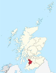
 Crosshouse Location within East Ayrshire | |
| Population | 2,690 (mid-2020 est.)[1] |
| Council area | |
| Country | Scotland |
| Sovereign state | United Kingdom |
| Police | Scotland |
| Fire | Scottish |
| Ambulance | Scottish |
Andrew Fisher, who was the fifth Prime Minister of Australia, was born in the village and a plaque commemorating him is located at the road junction to Knockentiber.
Health
The village is the location of a major hospital, Crosshouse Hospital, which was built to replace the Kilmarnock Infirmary.
Transport
Crosshouse is served by the Stagecoach Group, running through from Kilmarnock to Irvine and Ardrossan.
From 1873 until 1966 Crosshouse possessed a railway station situated at Knockentiber 1.4 km (7⁄8 mi) north of the village centre along the Kilmaurs road. It was the point at which the railway line from Kilmarnock divided, to Dalry to the north-west and Irvine to the west. The latter line has been converted into a walkway and cycleway.
References
- "Mid-2020 Population Estimates for Settlements and Localities in Scotland". National Records of Scotland. 31 March 2022. Retrieved 31 March 2022.
- "Mid-2020 Population Estimates for Settlements and Localities in Scotland". National Records of Scotland. 31 March 2022. Retrieved 31 March 2022.
External links
![]() Media related to Crosshouse at Wikimedia Commons
Media related to Crosshouse at Wikimedia Commons
Administrative centre: Kilmarnock, East Ayrshire Council Headquarters, London Road, KA3 7BU Council structure: Chief Executive: Eddie Fraser; Provost of the Council Cllr Barry Douglas; Leader of the Council Cllr Douglas Reid | ||
| Settlements |
|  |
| Secondary schools |
| |
| Members of the UK Parliament |
| |
| Members of the Scottish Parliament |
| |
| Places of interest |
| |
| Economy |
| |
| See also |
| |
Neighbouring council areas: South Ayrshire, North Ayrshire, Dumfries and Galloway, East Renfrewshire, South Lanarkshire | ||
Authority control | |
|---|---|
| General |
|
| National libraries | |
This East Ayrshire location article is a stub. You can help Wikipedia by expanding it. |
На других языках
[de] Crosshouse
Crosshouse ist ein Dorf in Schottland und liegt in unmittelbarer Nachbarschaft zu der Stadt Kilmarnock in East Ayrshire.- [en] Crosshouse
Другой контент может иметь иную лицензию. Перед использованием материалов сайта WikiSort.org внимательно изучите правила лицензирования конкретных элементов наполнения сайта.
WikiSort.org - проект по пересортировке и дополнению контента Википедии