world.wikisort.org - United_Kingdom
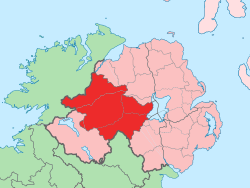
County Tyrone (/tɪˈroʊn/;[6] from Irish: Tír Eoghain, meaning 'land of Eoghan') is one of the six counties of Northern Ireland, one of the nine counties of Ulster and one of the thirty-two traditional counties of Ireland. It is no longer used as an administrative division for local government but retains a strong identity in popular culture.
County Tyrone
| |
|---|---|
County | |
 Coat of arms | |
| Nickname: The Red Hand County | |
| Motto(s): Consilio et Prudentia (Latin) "By Wisdom and Prudence" | |
 | |
| Country | United Kingdom |
| Region | Northern Ireland |
| Province | Ulster |
| Established | 1585 |
| County town | Omagh |
| Area | |
| • Total | 1,261 sq mi (3,270 km2) |
| • Rank | 8th |
| Highest elevation | 2,224 ft (678 m) |
| Population (2011) | 177,986 |
| • Rank | 10th[2] |
| Time zone | UTC±0 (GMT) |
| • Summer (DST) | UTC+1 (BST) |
| Postcode area | |
| Website | discovernorthernireland |
| Contae Thír Eoghain is the Irish name; Countie Tyrone,[3] Coontie Tyrone[4] and Coontie Owenslann[5] are Ulster Scots spellings (the latter used only by Dungannon & South Tyrone Borough Council). | |
Adjoined to the south-west shore of Lough Neagh, the county covers an area of 3,266 km2 (1,261 sq mi)[1] and has a population of about 177,986; its county town is Omagh. The county derives its name and general geographic location from Tír Eoghain, a Gaelic kingdom under the O'Neill dynasty which existed until the 17th century.
Name
The name Tyrone is derived from Irish Tír Eoghain 'land of Eoghan', the name given to the conquests made by the Cenél nEógain from the provinces of Airgíalla and Ulaid.[7] Historically, it was anglicised as Tirowen or Tyrowen, which are closer to the Irish pronunciation.
History
| Year | Pop. | ±% |
|---|---|---|
| 1653 | 3,988 | — |
| 1659 | 4,088 | +2.5% |
| 1821 | 261,865 | +6305.7% |
| 1831 | 304,468 | +16.3% |
| 1841 | 312,956 | +2.8% |
| 1851 | 255,661 | −18.3% |
| 1861 | 238,500 | −6.7% |
| 1871 | 215,766 | −9.5% |
| 1881 | 197,719 | −8.4% |
| 1891 | 171,401 | −13.3% |
| 1901 | 150,567 | −12.2% |
| 1911 | 142,665 | −5.2% |
| 1926 | 132,792 | −6.9% |
| 1937 | 127,586 | −3.9% |
| 1951 | 132,082 | +3.5% |
| 1961 | 133,919 | +1.4% |
| 1966 | 136,040 | +1.6% |
| 1971 | 139,073 | +2.2% |
| 1981 | 150,729 | +8.4% |
| 1991 | 156,284 | +3.7% |
| 2001 | 164,235 | +5.1% |
| 2011 | 177,986 | +8.4% |
| [8][9][10][11][12][13] | ||
Historically Tyrone (then Tír Eoghain or Tirowen) was much larger in size, stretching as far north as Lough Foyle, and comprised part of modern-day County Londonderry east of the River Foyle. The majority of County Londonderry was carved out of Tyrone between 1610 and 1620 when that land went to the Guilds of London to set up profit making schemes based on natural resources located there. Tyrone was the traditional stronghold of the various O'Neill clans and families, the strongest of the Gaelic Irish families in Ulster, surviving into the seventeenth century. The ancient principality of Tír Eoghain, the inheritance of the O'Neills, included the whole of the present counties of Tyrone and Londonderry, and the four baronies of West Inishowen, East Inishowen, Raphoe North and Raphoe South in County Donegal.[14]
In 1608 during O'Doherty's Rebellion areas of the country were plundered and burnt by the forces of Sir Cahir O'Doherty following his destruction of Derry. However, O'Doherty's men avoided the estates of the recently fled Earl of Tyrone around Dungannon, fearing Tyrone's anger if he returned from his exile.[15]
Geography
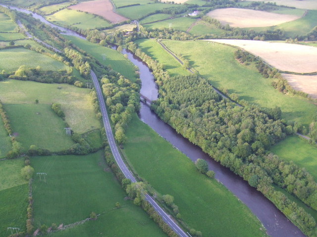
With an area of 3,155 square kilometres (1,218 sq mi), Tyrone is the largest county in Northern Ireland. The flat peatlands of East Tyrone border the shoreline of the largest lake in the British Isles, Lough Neagh, rising gradually across to the more mountainous terrain in the west of the county, the area surrounding the Sperrin Mountains, the highest point being Sawel Mountain at a height of 678 m (2,224 ft). The length of the county, from the mouth of the River Blackwater at Lough Neagh to the western point near Carrickaduff hill is 55 miles (89 km). The breadth, from the southern corner, southeast of Fivemiletown, to the northeastern corner near Meenard Mountain is 37.5 miles (60.4 km); giving an area of 1,261 square miles (in 1900).[14] Annaghone lays claim to be the geographical centre of Northern Ireland.
Tyrone is connected by land to the county of Fermanagh to the southwest; Monaghan to the south; Armagh to the southeast; Londonderry to the north; and Donegal to the west. Across Lough Neagh to the east, it borders County Antrim. It is the eighth largest of Ireland's thirty-two counties by area and tenth largest by population.[16] It is the second largest of Ulster's nine traditional counties by area and fourth largest by population.[17]
Administration
The county was administered by Tyrone County Council from 1899 until the abolition of county councils in Northern Ireland in 1973.[18]
Demography
It is one of four counties in Northern Ireland which currently has a majority of the population from a Catholic community background, according to the 2011 census.[citation needed] In 1900 County Tyrone had a population of 197,719,[14] while in 2011 it was 177,986.
Settlements
Large towns
(population of 18,000 or more and under 75,000 at 2001 Census)[19]
Medium towns
(population of 10,000 or more and under 18,000 at 2001 Census)[19]
Small towns
(population of 4,500 or more and under 10,000 at 2001 Census)[19]
Intermediate settlements
(population of 2,250 or more and under 4,500 at 2001 Census)[19]
Villages
(population of 1,000 or more and under 2,250 at 2001 Census)[19]
- Ardboe
- Carrickmore
- Dromore
- Fintona
- Fivemiletown
- Killyclogher
- Moy
- Newtownstewart
- Sion Mills
Small villages
(population of less than 1,000 at 2001 Census)[19]
- Altamuskin
- Altmore
- Ardstraw
- Artigarvan
- Augher
- Aughnacloy
- Ballygawley
- Ballymagorry
- Benburb
- Beragh
- Bready
- Brockagh
- Caledon
- Clady
- Clogher
- Clonoe
- Coagh
- Derryloughan
- Derrytresk
- Donaghmore
- Donemana
- Drumquin
- Edenderry
- Eglish
- Erganagh
- Eskra
- Evish
- Glenmornan
- Gortin
- Greencastle
- Killyclogher
- Loughmacrory
- Kildress
- Plumbridge
- Pomeroy
- Rock
- Stewartstown
- Tamnamore
- Trillick
- Tullyhogue
- Victoria Bridge
Subdivisions
Baronies
- Clogher
- Dungannon Lower
- Dungannon Middle
- Dungannon Upper
- Omagh East
- Omagh West
- Strabane Lower
- Strabane Upper
Parishes
Townlands
Future railway revival
There is the possibility of the line being reopened to Dungannon railway station from Portadown.[20]
Sport
Major sports in Tyrone include Gaelic games, association football, rugby union and cricket:
- Gaelic football is more widely played than hurling in Tyrone. The Tyrone GAA football side has had considerable success since 2000, winning four All Ireland titles (in 2003, 2005, 2008 and 2021). They have also won sixteen Ulster titles (1956, 1957, 1973, 1984, 1986, 1989, 1995, 1996, 2001, 2003, 2007, 2009, 2010, 2016, 2017 and 2021)[21] and two National League titles (in 2002[22] and 2003[23]).
- Association football also has a large following in Tyrone. Omagh Town F.C. were members of the Irish Football League until they folded in 2005 due to financial problems. Dungannon Swifts F.C. compete in the NIFL Premiership - the top division. Other teams include NIFL Championship side Dergview F.C.
- Rugby union is very popular in the county. Dungannon RFC plays in the All-Ireland League. Other teams include Omagh RFC, Clogher Valley RFC, Cookstown RFC and Strabane RFC.
- International Cricket is also played on the Bready Cricket Club Ground which is owned by Bready Cricket Club. It is Ireland's fourth venue for International Cricket hosting its first International Cricket match when Ireland played against Scotland in a series of T20I matches in June 2015.[24][25] It was selected as a venue to host matches in the 2015 ICC World Twenty20 Qualifier tournament.[26]
Notable people
- Philomena Begley, Irish country music singer
- James E. Boyd, seventh Governor of Nebraska[27]
- Paul Brady, musician
- William Burke (1792–1829), grave robber and murderer
- Peter Canavan, former All Ireland Tyrone captain
- William Carleton (1794–1869), writer
- Chipzel, musician
- Darren Clarke, professional golfer
- Tom Clarke, Irish Republican and leader of the 1916 Easter Rising
- Jimmy Cricket, comedian
- Sidney Elisabeth Croskery, doctor[28]
- Austin Currie, politician, founding member SDLP; Member of Parliament (MP) and later Teachta Dála (TD)
- Janet Devlin, soul and pop artist and contestant on The X Factor (UK)
- Ryan Dolan, Ireland representative at the Eurovision Song Contest 2013
- Brian Dooher, former captain of the Tyrone senior football team
- Hugo Duncan, singer and broadcaster on BBC Radio Ulster
- John Dunlap (1747–1812), publisher of the first American daily newspaper the Pennsylvania Packet in 1784, also the printer of the American Declaration of Independence
- Brian Friel, dramatist and theatre director
- Sylvia Hermon, Member of Parliament for North Down, born in Galbally, County Tyrone
- Aaron Hughes, captain of the Northern Ireland football team
- John Hughes (1797–1864), first Archbishop of Roman Catholic Diocese of New York[29]
- Martin Hurson, Irish Republican
- Ryan Kelly, singer with Celtic Thunder[30]
- Benedict Kiely (1919–2007), writer and broadcaster
- Gerry McKenna MRIA (1953–), biologist; Vice Chancellor and President, University of Ulster; Senior Vice President, Royal Irish Academy[31]
- William McMaster (1811–1887), founder of Canadian Bank of Commerce and namesake of McMaster University
- Mary Mallon (1869–1938), more commonly known as Typhoid Mary
- W. F. Marshall (1888–1954), the 'Bard of Tyrone', Presbyterian minister, author and poet
- Thomas Mellon, founder of Mellon Bank, now Bank of New York Mellon
- Sister Nivedita (1867–1911), Irish social activist
- Flann O'Brien (1911–1966), writer
- Dominic Ó Mongain (c.1715–1770s), poet and harpist
- Arthur O'Neill (c.1737–1816), travelling blind Irish harpist
- Hugh O'Neill, Earl of Tyrone (Aodh Mór Ó Néill) (c.1550–1616), Irish leader during the Nine Years' War
- Thomas Porter, member of the Wisconsin State Assembly
- Martha M. Simpson (1864-1948), educationalist
- Victor Sloan MBE, visual artist
- Ivan Sproule, football player for Bristol City F.C.
- Dennis Taylor, former world snooker champion
- John K. Tener, former baseball player and Governor of Pennsylvania. Creator of Congressional Baseball Game.
- Colin Broderick, Author and Filmographer.
See also
- Abbeys and priories in Northern Ireland (County Tyrone)
- High Sheriff of Tyrone
- List of civil parishes of County Tyrone
- List of places in County Tyrone
- List of townlands in County Tyrone
- Lord Lieutenant of Tyrone
- Ulster American Folk Park
- The Moorlough Shore
References
- Northern Ireland General Register Office (1975). "Table 1: Area, Buildings for Habitation and Population, 1971". Census of Population 1971; Summary Tables (PDF). Belfast: HMSO. p. 1. Archived (PDF) from the original on 23 July 2019. Retrieved 28 August 2019.
- Cookstown.gov.uk Archived 27 September 2007 at the Wayback Machine
- "North-South Ministerial Council: 2010 Annual Report in Ulster Scots" (PDF). Archived from the original (PDF) on 27 February 2013. Retrieved 18 January 2013.
- "North-South Ministerial Council: 2006 Annual Report in Ulster Scots" (PDF). Archived from the original (PDF) on 27 February 2013. Retrieved 18 January 2013.
- "Dungannon and South Tyrone Borough Council". Dungannon.gov.uk. Archived from the original on 8 April 2013. Retrieved 18 January 2013.
- BBC (1990). Graham E. Pointon (ed.). BBC pronouncing dictionary of British names (2 ed.). New York: Oxford University Press. p. 248. ISBN 0192827456.
Tyrone Co. name, ti'roʊn
- Art Cosgrove (2008); "A New History of Ireland, Volume II: Medieval Ireland 1169-1534". Oxford University Press.
- For 1653 and 1659 figures from Civil Survey Census of those years, Paper of Mr Hardinge to Royal Irish Academy, 14 March 1865.
- "Census for post 1821 figures". Cso.ie. Archived from the original on 9 March 2005. Retrieved 18 January 2013.
- "Histpop.org". Histpop.org. Archived from the original on 7 May 2016. Retrieved 18 January 2013.
- "Nisranews.gov.uk". Nisranew.nisra.gov.uk. Archived from the original on 17 February 2012. Retrieved 18 January 2013.
- Lee, JJ (1981). "On the accuracy of the Pre-famine Irish censuses". In Goldstrom, J. M.; Clarkson, L. A. (eds.). Irish Population, Economy, and Society: Essays in Honour of the Late K. H. Connell. Oxford, England: Clarendon Press.
- Mokyr, Joel; O Grada, Cormac (November 1984). "New Developments in Irish Population History, 1700–1850". The Economic History Review. 37 (4): 473–488. doi:10.1111/j.1468-0289.1984.tb00344.x. hdl:10197/1406. Archived from the original on 4 December 2012. Retrieved 3 September 2009.
- Joyce, Patrick Weston; Sullivan, Alexander Martin; Nunan, P. D. (1900). Atlas and Cyclopedia of Ireland. Murphy and McCarthy. Archived from the original on 19 September 2008. Retrieved 24 February 2009.
 This article incorporates text from this source, which is in the public domain.
 - McCavitt, John. The Flight of the Earls. Gill & MacMillan, 2002. p.143-44
- Corry, Eoghan (2005). The GAA Book of Lists. Hodder Headline Ireland. pp. 186–191. ISBN 0-340-89695-7.
- Marie Veronica Tarpey The role of Joseph McGarrity in the struggle for Irish independence Archived 17 June 2016 at the Wayback Machine
- "Local Government Act (Northern Ireland) 1972". Legislation.gov.uk. Archived from the original on 30 October 2019. Retrieved 29 November 2019.
- "Statistical classification of settlements". NI Neighbourhood Information Service. Archived from the original on 17 February 2010. Retrieved 23 February 2009.
- "All aboard! Dungannon railway hopes revived". Archived from the original on 1 September 2021. Retrieved 1 September 2021.
- The Tyrone GAA team have won the Ulster Senior Championship on eight occasions in the 20th century
- Sean Moran (29 April 2002). "Tyrone's superiority is total". The Irish Times. Retrieved 14 February 2022.
- "Tyrone outclass Laois". BBC News. 4 May 2003. Retrieved 14 February 2022.
- "Tyrone Kane given first Ireland call-up for World T20 qualifiers". BBC Sport. Archived from the original on 2 June 2015. Retrieved 1 June 2015.
- Ireland's Bready Cricket Club Gets ICC's Recognition[permanent dead link]
- "ICC announces schedule of ICC World Twenty20 Qualifier 2015". International Cricket Council. Archived from the original on 18 May 2015. Retrieved 14 May 2015.
- "Kansas Governor Walter Roscoe Stubbs". National Governors Association. Archived from the original on 14 June 2012. Retrieved 29 September 2012.
- Sidney Elisabeth Croskery: Whilst I Remember (1983), ISBN 978-0-85640-260-9
- Who Was Who in America, Historical Volume, 1607–1896. Chicago, IL: Marquis Who's Who. 1963.
- "Ryan Kelly". Archived from the original on 25 November 2015. Retrieved 24 November 2015.
- Professor P G (Gerry) McKenna Archived 20 May 2017 at the Wayback Machine. gerrymckenna.co.uk.
Pointon, GE (1990), BBC Pronouncing Dictionary of British Names (2nd ed.), Oxford: Oxford University Press, p. 92, ISBN 0-19-282745-6
Further reading
- Joost, Augusteijn (ed.) (1920s). The Memoirs of John M. Regan, a Catholic Officer in the RIC and RUC, 1909–48. Co. Tyrone. ISBN 978-1-84682-069-4.
- McNeill, I. (2010). The Flora of County Tyrone. National Museums of Northern Ireland. ISBN 978-1-905989-17-1
External links
- County Tyrone at Curlie
- Tyrone on the interactive map of the counties of Great Britain and Ireland – Wikishire
- A Flavour of Tyrone
- County Tyrone.com
Places adjacent to County Tyrone | ||||||||||||||||
|---|---|---|---|---|---|---|---|---|---|---|---|---|---|---|---|---|
| ||||||||||||||||
Counties of Ireland | ||
|---|---|---|
The counties are listed per province | ||
 | ||
| ||
O'Neill dynasty | |
|---|---|
| General |
|
| Early progenitors |
|
| O'Neill |
|
| O'Neill Roe |
|
| O'Neill Clandeboye |
|
| O'Neill of the Fews |
|
| Places |
|
| Kinsmen |
|
| |
| History |
|
|---|---|
| General and events |
|
| Acts of Parliament |
|
| Gaelic conquests |
|
| Politics and society |
|
| Monarchs and rulers |
|
| |
Authority control | |
|---|---|
| General | |
| National libraries | |
| Other |
|
На других языках
- [en] County Tyrone
[ru] Тирон (графство)
Тирон (англ. Tyrone, ирл. Tír Eoghain) — историческое графство на севере Ирландии. Входит в состав исторической провинции Ольстер на территории Северной Ирландии. Административный центр и крупнейший город — Ома. Население 177 986 человек (4-е место среди графств Северной Ирландии; данные 2011 года).Другой контент может иметь иную лицензию. Перед использованием материалов сайта WikiSort.org внимательно изучите правила лицензирования конкретных элементов наполнения сайта.
WikiSort.org - проект по пересортировке и дополнению контента Википедии