world.wikisort.org - Ireland
County Galway (/ˈɡɔːlweɪ/ GAWL-way; Irish: Contae na Gaillimhe) is a county in Ireland. It is in the West of Ireland, taking up the south of the province of Connacht.
This article needs additional citations for verification. (May 2015) |
County Galway
Contae na Gaillimhe | |
|---|---|
County | |
 Coat of arms | |
| Nickname: The Hooker County | |
| Motto(s): Irish: Ceart agus Cóir "Righteousness and Justice" | |
| Anthem: (unofficial)[1] | |
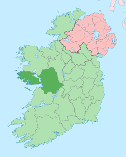 Location in Ireland | |
| Country | Ireland |
| Province | Connacht |
| Region | Northern and Western |
| Established | c. 1569[2][3] |
| County town | Galway |
| Government | |
| • Local authorities | County Council and City Council |
| • Dáil constituency |
|
| • EP constituency | Midlands–North-West |
| Area | |
| • Total | 6,151 km2 (2,375 sq mi) |
| • Rank | 2nd |
| Highest elevation (Benbaun) | 729 m (2,392 ft) |
| Population | |
| • Total | 276,451 |
| • Rank | 5th |
| • Density | 45/km2 (120/sq mi) |
| Time zone | UTC±0 (WET) |
| • Summer (DST) | UTC+1 (IST) |
| Eircode routing keys | F31, H53, H54, H62, H65, H71, H91 (primarily) |
| Telephone area codes | 090, 091, 093, 099 (primarily) |
| Vehicle index mark code | G |
| Website | www |
There are several Irish-speaking areas in the west of the county. The traditional county includes, and is named for, the city of Galway, but the city and county are separate local government areas, administered by the local authorities of Galway City Council in the urban area and Galway County Council in the rest of the county.
The population of the county was 276,451 at the 2022 census.[5][6]
History

The first inhabitants in the Galway area arrived over 7000 years ago. Shell middens indicate the existence of people as early as 5000 BC.
The county originally comprised several kingdoms and territories which predate the formation of the county. These kingdoms included Aidhne, Uí Maine, Maigh Seóla, Conmhaícne Mara, Soghain and Máenmaige. County Galway became an official entity around 1569 AD.[7] The region known as Connemara retains a distinct identity within the county, though its boundaries are unclear, and it may account for as much as one third, or as little as 20%, of the county.
The county includes a number of inhabited islands, such as the Aran Islands (Irish: Oileáin Árann) and Inishbofin (Inis Bó Fine).
With the arrival of Christianity many monasteries were built in the county. Monasteries kept written records of events in the area and of its people. These were followed by a number of law-tracts, genealogies, annals and miscellaneous accounts. Extant manuscripts containing references to Galway include:
|
|
| Year | Pop. | ±% |
|---|---|---|
| 1600 | 19,706 | — |
| 1610 | 14,233 | −27.8% |
| 1653 | 18,209 | +27.9% |
| 1659 | 33,390 | +83.4% |
| 1668 | 45,678 | +36.8% |
| 1672 | 55,700 | +21.9% |
| 1680 | 58,950 | +5.8% |
| 1690 | 63,711 | +8.1% |
| 1700 | 65,112 | +2.2% |
| 1710 | 67,888 | +4.3% |
| 1720 | 70,345 | +3.6% |
| 1725 | 71,798 | +2.1% |
| 1735 | 73,470 | +2.3% |
| 1745 | 71,997 | −2.0% |
| 1755 | 68,955 | −4.2% |
| 1765 | 79,883 | +15.8% |
| 1771 | 81,225 | +1.7% |
| 1775 | 87,226 | +7.4% |
| 1781 | 94,666 | +8.5% |
| 1788 | 101,557 | +7.3% |
| 1790 | 116,774 | +15.0% |
| 1801 | 123,445 | +5.7% |
| 1811 | 145,333 | +17.7% |
| 1813 | 142,808 | −1.7% |
| 1816 | 155,297 | +8.7% |
| 1821 | 169,503 | +9.1% |
| 1831 | 204,691 | +20.8% |
| 1841 | 440,198 | +115.1% |
| 1851 | 321,684 | −26.9% |
| 1861 | 271,478 | −15.6% |
| 1871 | 248,458 | −8.5% |
| 1881 | 242,005 | −2.6% |
| 1891 | 214,712 | −11.3% |
| 1901 | 192,549 | −10.3% |
| 1911 | 182,224 | −5.4% |
| 1926 | 169,366 | −7.1% |
| 1936 | 168,198 | −0.7% |
| 1946 | 165,201 | −1.8% |
| 1951 | 160,204 | −3.0% |
| 1956 | 155,553 | −2.9% |
| 1961 | 149,887 | −3.6% |
| 1966 | 148,340 | −1.0% |
| 1971 | 149,223 | +0.6% |
| 1979 | 167,838 | +12.5% |
| 1981 | 172,018 | +2.5% |
| 1986 | 178,552 | +3.8% |
| 1991 | 180,364 | +1.0% |
| 1996 | 188,854 | +4.7% |
| 2002 | 209,077 | +10.7% |
| 2006 | 231,670 | +10.8% |
| 2011 | 250,541 | +8.1% |
| 2016 | 258,058 | +3.0% |
| 2022 | 276,451 | +7.1% |
| [8][9][10][11][12][13][5][6] | ||
Irish language
Nearly 20% of the population of County Galway live in the Gaeltacht (Irish-speaking districts). County Galway is home to the largest Gaeltacht Irish-speaking region in Ireland. There are over 48,000 people living within this region, which extends from Galway city westwards through Connemara. The region consists of the following Irish-speaking areas: Galway City Gaeltacht (parts of the city), Gaeltacht Cois Fharraige, Conamara Theas, Aran Islands, and Duiche Sheoigheach (a part of the northern Galway region known as "Joyce Country" and Maam Valley).
All schools within the Gaeltacht use the Irish language for classroom instruction. There is also a third-level constituent college of NUIG called Acadamh na hOllscolaíochta Gaeilge in Carraroe and Carna. Clifden is the largest town in the region. Galway City is also home to Ireland's only Irish-language theatre, Taibhdhearc na Gaillimhe. There is a strong Irish-language media presence in this area too, which boasts the radio station Raidió na Gaeltachta and Foinse newspaper in Carraroe and national TV station TG4 in Baile na hAbhann. The Aran Islands are also part of the Galway Gaeltacht.
According to Census 2016, there were 84,249 people in County Galway who could speak Irish.[14] According to Census 2011, the Galway city and county Gaeltacht has a population of 48,907, of which 30,978 said they could speak Irish; 23,788 can be classed as native Irish speakers, while 7,190 speak Irish daily only within the classroom. There are 3,006 attending the ten Gaelscoil (Irish language primary schools) and three Gaelcholáiste (Irish language secondary schools) outside the Galway Gaeltacht.[15] According to the Irish Census 2016, there are 9,445 people in the county who identify themselves as being daily Irish speakers outside the education system.[14]
Local government and politics

Galway City Council and Galway County Council are the local authorities for the respective local government areas. The local government area of County Galway includes some suburbs of the city not within the city area. Each local authority is responsible for certain local services such as sanitation, planning and development, libraries, the collection of motor taxation, local roads and social housing.
Under the Local Government (Ireland) Act 1898, County Galway was divided into the urban districts of Ballinasloe and Galway, and the rural districts of Ballinasloe No. 1, Clifden, Galway, Glennamaddy, Gort, Loughrea, Mount Bellew, Oughterard, Portumna, and Tuam.[16] Loughrea, within the rural district of Loughrea, and Tuam, within the rural district of Tuam, had town commissioners.[17] The rural districts were abolished in 1925.[18]
In 1937, the urban district of Galway became the borough of Galway, remaining part of County Galway.[19] In 1986, the borough of Galway became the county borough of Galway and ceased to part of County Galway.[20][21] In 2002, all county boroughs were redefined as cities.[22]
In 2002, the urban district of Ballinasloe and the town commissioners of Loughrea and Tuam became town councils.[23] All town councils in Ireland were abolished in 2014.[24]
As part of the Northern and Western Region, Galway County Council has three representatives and Galway City Council has two representatives on the Northern and Western Regional Assembly.[25]
The county is part of three Dáil constituencies: Galway East (3 seats), Galway West (5 seats) and Roscommon–Galway (5 seats).[26] It is part of the Midlands–North-West constituency for European elections.[27]
Geography


County Galway is home to Na Beanna Beola (Twelve Bens) mountain range, Na Sléibhte Mhám Toirc (the Maum Turk mountains), and the low mountains of Sliabh Echtghe (Slieve Aughty). The highest point in the county is one of the Twelve Bens, Benbaun, at 729m.
Lakes
County Galway is partly home to a number of Ireland's largest lakes including Lough Corrib (the largest lake in the Republic of Ireland), Lough Derg and Lough Mask. The county is also home to a large number of smaller lakes, many of which are in the Connemara region. These include Lough Anaserd, Ardderry Lough, Aughrusbeg Lough, Ballycuirke Lough, Ballynahinch Lake, Lough Bofin, Lough Cutra, Derryclare Lough, Lough Fee, Glendollagh Lough, Lough Glenicmurrin, Lough Inagh, Kylemore Lough, Lettercraffroe Lough, Maumeen Lough, Lough Nafooey, Lough Rea, Ross Lake and Lough Shindilla.
Climate
The location of County Galway, situated on the west coast of Ireland, allows it to be directly influenced by the Gulf Stream. Temperature extremes are rare and short lived, though inland areas, particularly east of the Corrib, can boast some of the highest recorded temperatures of the summer in the island of Ireland (sometimes exceeding 30 °C); though these temperatures only occur when land warmed east winds sweep the area; the opposite effect can occur in the winter. Overall, however, Galway is influenced mainly by Atlantic airstreams which bring ample rainfall in between the fleeting sunshine. Rainfall occurs in every month of the year, though the late autumn and winter months can be particularly wet as Atlantic cyclonic activity increases and passes over and around the area, and which is why Galway tends to bear the brunt of severe windstorms that can occur between August and March. The county on average receives about 1300mm of rainfall annually, though some areas along the west coast of the county can receive up to 1900mm and beyond. Extreme weather such as blizzards, thunderstorms, flash flooding and hail, though rare, can and do occur, particularly when air masses of continental origin are undercut by more humid and unstable Atlantic flows.
Flora and fauna
One of the least densely populated counties, County Galway harbors a variety of wildlife. The region's biodiversity is best represented by Connemara National Park, situated in the west of the county.
Largest settlements in County Galway (2016 Census)
- Galway, 79,934
- Tuam, 8,767
- Ballinasloe, 6,662
- Loughrea, 5,556
- Oranmore, 4,990
- Athenry, 4,445
- Gort, 2,994
Economy
According to numbers published by Galway Chamber of Commerce in early 2019, there were then 196 information and communications technology (ICT) organisations in Galway, including IBM, SAP, Oracle and Cisco.[28] There is a number of medical device companies in the area, including Medtronic (with approximately 1,800 employees) and Boston Scientific (2,800 employees).[28]
Sports
Gaelic games are the most popular sport in the county. Galway had traditional regions in which Gaelic football or hurling is played. For example, in south and eastern County Galway, in places such as Portumna, Gort, Clarinbridge and Athenry, hurling is the dominant sport with successful teams at county and national level. Most of the rest of the county is considered to be footballing territory, with most of the county players being from The Tuam area, Oughterard, Moycullen or parts of Galway city.
Galway United FC compete in the SSE Aitricity League of Ireland and plays home games in Eamonn Deacy Park.
Connacht Rugby competes in the United Rugby Championship is based in Galway city. The two main amateur rugby clubs in the county are Galway Corinthians RFC and Galwegians RFC which compete in the All-Ireland League.
Athletics is also a very popular sport in Galway, a few clubs being; Galway City Harriers, Craughwell Athletic Club, Athenry A.C, Tuam A.C, Loughrea A.C and many others.
Notable people
- Mícheál Ó Cellaigh (fl. 1875) Irish scribe
- Tomás Ó Reaftaraigh (fl. 1899) Irish scribe
- Nicola Coughlan Irish Actor
See also
- Connacht Irish
- Galway GAA
- List of monastic houses in Ireland (County Galway)
- Joyce Country
- Lord Lieutenant of Galway
- High Sheriff of County Galway
- High Sheriff of Galway Town
- Western Railway Corridor
- Wild Atlantic Way
References
- "The GAA and the All Ireland Championship". Dochara. 30 December 2008. Archived from the original on 4 March 2016.
- MANNION, JOSEPH (20 June 2019). "Elizabethan County Galway: The Origin and Evolution of an Administrative Unit of Tudor Local Government". Journal of the Galway Archaeological and Historical Society. 64: 64–89. JSTOR 24612855.
- "County Galway, Ireland Genealogy Genealogy - FamilySearch Wiki". www.familysearch.org. Archived from the original on 28 July 2020. Retrieved 20 June 2019.
- "County Profiles – Galway". Western Development Commission. Archived from the original on 2 June 2021. Retrieved 2 June 2021.
- "Census 2016 Sapmap Area: County Galway City". Central Statistics Office (Ireland). Archived from the original on 21 October 2018. Retrieved 21 October 2018.
- "Census 2016 Sapmap Area: County Galway County". Central Statistics Office (Ireland). Archived from the original on 21 October 2018. Retrieved 21 October 2018.
- Mannion, Joseph (2012). "Elizabethan County Galway: The Origin and Evolution of an Administrative Unit of Tudor Local Government". Journal of the Galway Archaeological and Historical Society. 64: 64–89. JSTOR 24612855.
- For 1653 and 1659 figures from Civil Survey Census of those years, Paper of Mr Hardinge to Royal Irish Academy 14 March 1865.
- "Server Error 404 - CSO - Central Statistics Office". www.cso.ie. Archived from the original on 21 March 2019. Retrieved 20 June 2019.
- "Histpop - The Online Historical Population Reports Website". www.histpop.org. Archived from the original on 7 May 2016.
- NISRA - Northern Ireland Statistics and Research Agency (c) 2013 Archived 17 February 2012 at the Wayback Machine. Nisranew.nisra.gov.uk (27 September 2010). Retrieved on 23 July 2013.
- Lee, JJ (1981). "On the accuracy of the Pre-famine Irish censuses". In Goldstrom, J. M.; Clarkson, L. A. (eds.). Irish Population, Economy, and Society: Essays in Honour of the Late K. H. Connell. Oxford, England: Clarendon Press.
- Mokyr, Joel; O Grada, Cormac (November 1984). "New Developments in Irish Population History, 1700-1850". The Economic History Review. 37 (4): 473–488. doi:10.1111/j.1468-0289.1984.tb00344.x. hdl:10197/1406. Archived from the original on 4 December 2012.
- "Census of Population 2016 - Profile 10 Education, Skills and the Irish Language". Central Statistics Office. Archived from the original on 8 December 2020. Retrieved 11 October 2018.
- "Oideachas Trí Mheán na Gaeilge in Éirinn sa Ghalltacht 2010-2011" (PDF) (in Ga). gaelscoileanna.ie. 2011. Archived (PDF) from the original on 19 April 2012. Retrieved 9 January 2012.
- Clancy, John Joseph (1899). A handbook of local government in Ireland: containing an explanatory introduction to the Local Government (Ireland) Act, 1898: together with the text of the act, the orders in Council, and the rules made thereunder relating to county council, rural district council, and guardian's elections: with an index. Dublin: Sealy, Bryers and Walker. p. 424.
- "1926 Census: Table 9: Population, Area and Valuation of urban and rural districts and of all towns with a population of 1,500 inhabitants or over, showing particulars of town and village population and of the number of persons per 100 acres" (PDF). Central Statistics Office. p. 27. Archived (PDF) from the original on 27 April 2016. Retrieved 4 October 2022.
- Local Government Act 1925, s. 3: Abolition of rural district councils (No. 5 of 1925, s. 3). Signed on 26 March 1925. Act of the Oireachtas. Retrieved 22 December 2021, from Irish Statute Book.
- Local Government (Galway) Act 1937, s. 4: Formation of the Borough of Galway (No. 3P of 1937, s. 4). Signed on 10 June 1937. Act of the Oireachtas. Retrieved 24 June 2021, from Irish Statute Book.
- Local Government (Reorganisation) Act 1985, s. 5: Establishment of Borough of Galway as County Borough (No. 7 of 1985, s. 5). Signed on 3 April 1985. Act of the Oireachtas. Retrieved 24 June 2021, from Irish Statute Book.
- Local Government (Reorganisation) Act 1985 (County Borough of Galway) (Appointed Day) Order 1985 (S.I. No. 425 of 1985). Signed on 18 December 1985. Statutory Instrument of the Government of Ireland. Retrieved 24 June 2021, from Irish Statute Book.
- Local Government Act 2001, s. 10: Local government areas (No. 37 of 2001, s. 10). Signed on 21 July 2001. Act of the Oireachtas. Retrieved 24 June 2021, from Irish Statute Book.
- Local Government Act 2001, 6th Sch.: Local Government Areas (Towns) (No. 37 of 2001, 6th Sch.). Signed on 21 July 2001. Act of the Oireachtas. Retrieved 21 May 2022, from Irish Statute Book.
- Local Government Reform Act 2014, s. 24: Dissolution of town councils and transfer date (No. 1 of 2014, s. 24). Signed on 27 January 2014. Act of the Oireachtas. Retrieved 21 May 2022, from Irish Statute Book.
- Local Government Act 1991 (Regional Assemblies) (Establishment) Order 2014 (S.I. No. 573 of 2014). Signed on 16 December 2014. Statutory Instrument of the Government of Ireland. Retrieved 25 February 2022, from Irish Statute Book.
- Electoral (Amendment) (Dáil Constituencies) Act 2017, Schedule (No. 39 of 2017, Schedule). Signed on 23 December 2017. Act of the Oireachtas. Retrieved 10 January 2022, from Irish Statute Book.
- European Parliament Elections (Amendment) Act 2019, s. 7 (No. 7 of 2019, s. 7). Signed on 12 March 2019. Act of the Oireachtas. Retrieved 10 January 2022, from Irish Statute Book.
- "Galway in Numbers". galwaychamber.com. Galway Chamber of Commerce. Archived from the original on 7 January 2019. Retrieved 24 March 2019.
Select Bibliography
- Conor McNamara, 'War and Revolution in the West of Ireland, Galway 1913-22' (Irish Academic Press, 2019).
- History of Galway, James Hardiman, 1820
- Education in the Diocese of Kilmachduagh in the nineteenth century, Sr. Mary de Lourdes Fahy, Convent of Mercy, Gort, 1972
- "On the Corporation Books of Galway", Trench, W.F. & Lawson, T.D., Journal of the Galway Archaeological and Historical Society Vol. 1, 1900–1901, no. 2.
- "The Lurgan canoe", Costello, T.B, JGAHS Vol. 2, 1902, no. 1.
- Blake Family Records, vol. 1, Martin J. Blake.
- "Portrait of Sir Valentine Blake of Menlough, 3rd Baronet (1608–1652)", anon, JGAHS Vol. 3, 1903–1904, no. 3.
- "Will of Geoffrey French of Galway, A.D. 1528", Martin J. Blake, JGAHS Vol. 4, 1905 –1906, no. 4.
- "A De Burgo silver chalice, A.D. 1494: with notes on the family of Bourke of Turlough, Co. Mayo; drawing & text."JGAHS Vol. 5, 1907–1908, no. 4.
- Old Galway, Maureen Donovan-O'Sullivan, 1942.
- "The Anglo-Normans in Co. Galway: the process of colonization", Patrick Holland, JGAHS Vol. 41, 1987–88.
- Galway: History and Society, ed. Gerard Moran and Raymond Gillespie, Geography Publications, Dublin, 1996, ISBN 0-906602-75-0
(selections below)
- "The Topography of Medieval and Early Modern Galway City";
- "From Warlords to Landlords: Political and Social Change in Galway 1540-1640";
- "Religion and the Laity in Early Modern Galway";
- "The Transfer of Power: Galway 1642-1703";
- "The Politics of Protestant ascendency: County Galway 1650-1832";
- "Landlords and Land Usage in Eighteenth Century Galway";
- "The Galway Tribes as Landowners and Gentry
- "The Response of the Poor Law to the Great Famine in County Galway
- "The Encumbered Estates Court and Galway Property 1849-58
- "Bishop John MacEvilly and the Catholic Church in Late Nineteenth Century Galway
- "Minor Famines and Relief in Galway, 1815-1925"
- "From Connacht to North America: State Aided Emigration from County Galway in the 1880s"
- "Trade Unionism in County Galway, 1898-1914"
- "Scríobhaithe Lámhscribhínni Gaeilge I nGallimh"
- "The Galway Gaeltacht, 1926-81: a Sociolinguistic Study of Continuity and Change"
- A town tormented by the sea: Galway 1790-1914, John Cunningham, 2004.
- The Ploughman on the Pound Note, Eugene Duggan, 2004.
- Land and Revolution" - Nationalist Politics in the West of Ireland 1891 - 1921, Fergus Campbell, 2005.
- "The de Berminghams, Barons of Athenry", Paul Mohr, JGAHS Vol. 63, 2011.
- Clár Amhrán Mhaigh Cuilinn, Ciarán Ó Con Cheanainn, 2011.
- He Who Dared and Died" - The Life and Death of an SAS Original, Sergeant Chris O'Dowd MM, Gearóid O'Dowd, 2011
- The case of the Craughwell Prisoners during the Land War in Co. Galway, 1879–85, Pat Finnegan, 2012
- Loughrea, that den of infamy: The Land War in County Galway, 1879–82, Pat Finnegan, 2014.
- East Galway agrarian agitation and the burning of Ballydugan House, 1922, Anne O'Riordan, 2015.
- Rebellion in Galway - Easter Rising 1916 Kevin Jordan, 2016.
- The Tribes of Galway: 1124-1642, Adrian Martyn, 2016.
- He was Galway:Máirtín Mór McDonogh, 1860–1934, Jackie Uí Chionna, 2016.
External links
Places adjacent to County Galway | ||||||||||||||||
|---|---|---|---|---|---|---|---|---|---|---|---|---|---|---|---|---|
| ||||||||||||||||
Places in County Galway | ||
|---|---|---|
County town: Galway | ||
| Towns |  | |
| Villages |
| |
| Townlands / places |
| |
| Baronies |
| |
| Islands | ||
| ||
Counties of Ireland | ||
|---|---|---|
The counties are listed per province | ||
 | ||
| ||
Authority control | |
|---|---|
| General | |
| National libraries | |
| Other |
|
На других языках
[de] County Galway
Das County Galway (irisch Gaillimh) ist ein County an der Westküste der Republik Irland. Es ist in der Provinz Connacht gelegen; ihre Hauptstadt ist Galway. In der Region Connemara sind zahlreiche Gaeltacht-Gebiete ausgewiesen, wo noch verstärkt Irisch gesprochen wird.- [en] County Galway
[ru] Голуэй (графство)
Го́луэй (ирл. Gaillimh, англ. Galway) — графство на западе Ирландии. Административный центр и крупнейший город — Голуэй. Население 250 653 человек (3-е место среди графств Республики Ирландия; данные 2011 г.). Площадь территории 6149 км² (2-е место). В области Коннемара находится один из четырёх районов Ирландии, где по данным 2007 г. большая часть населения (свыше 67 %) использует в быту ирландский язык, т. н. Гэлтахт категории «A».Другой контент может иметь иную лицензию. Перед использованием материалов сайта WikiSort.org внимательно изучите правила лицензирования конкретных элементов наполнения сайта.
WikiSort.org - проект по пересортировке и дополнению контента Википедии