world.wikisort.org - United_Kingdom
Annahilt / Anahilt (from Irish: Eanach Eilte)[1] is a village and civil parish in north County Down, Northern Ireland. It is 7.5 miles (12 kilometres) south of Lisburn, and about 14 miles south-west of Belfast, on the main road between Ballynahinch and Hillsborough. In the 2001 Census the village had a population of 1,148. Annahilt has a distinctive drumlin setting, with a small wooded estate on a ridge to the west, and panoramic views on the approaches to the village.
Annahilt/Anahilt
| |
|---|---|
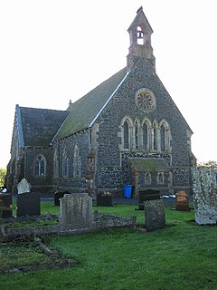
 Church of the Ascension, Annahilt | |
 Location within County Down | |
| Population | 1,148 (2001) |
| Irish grid reference | J296562 |
| • Belfast | 14 mi (23 km) |
| District | |
| County |
|
| Country | Northern Ireland |
| Sovereign state | United Kingdom |
| Post town | HILLSBOROUGH |
| Postcode district | BT26 |
| Dialling code | 028, +44 28 |
| UK Parliament |
|
| NI Assembly |
|
Annahilt has a primary school, hair dressers, Scout Hall, an Orange Hall, a residential care home and a play park. There is also a business park to the north, on the Glebe Road. Annahilt also has a three-star caravan site, known as the 'Lakeside View Caravan Park', on the Magheraconluce Road.[2]
History
Maps of the early 19th century show little development at Annahilt beyond a schoolhouse and a small number of dwellings near the main crossroads. The settlement grew much in the second half of the 20th century. The primary school was founded in 1801.[3]
A church was founded on the site of the current Annahilt Church of Ireland (Church of the Ascension) in the 8th century. Founded by Saint Molibba, it was known as Enaceilte. The church was rebuilt in 1422 and again in 1741, while the present church was built in 1856. The only remaining part of the medieval church is a ruined tower, which sits in the graveyard.[4]
Transport
Translink (Ulsterbus) operate bus services linking the village with Lisburn, Belfast, Dromara and Newcastle.
Demography
Annahilt is classified as a village by the Northern Ireland Statistics and Research Agency (NISRA) (i.e. with population between 1,000 and 2,250 people). On Census day (29 April 2001) there were 1148 people living in Annahilt. Of these:[5]
- 27.2% were aged under 16 years and 13.3% were aged 60 and over
- 48.3% of the population were male and 51.7% were female
- 5.1% were from a Catholic background and 91.3% were from a Protestant background
- 2.6% of people aged 16–74 were unemployed
Civil parish of Annahilt
The civil parish is mainly in the historic barony of Iveagh Lower, Lower Half, with one townland in the barony of Kinelarty.[6]
Townlands
The civil parish contains the following townlands:[6]
- Aghnaleck
- Ballycrune
- Ballykeel Lougherne
- Ballylintagh
- Ballymurphy
- Cargacreevy
- Cargygray
- Carricknadarriff
- Cluntagh
- Glebe
- Magheraconluce
See also
- List of civil parishes of County Down
References
- Placenames Database of Ireland
- "Lakeside View Caravan Park". Archived from the original on 7 July 2011. Retrieved 12 March 2010.
- Anahilt Community Web pages Archived September 28, 2007, at the Wayback Machine
- "Annahilt Church of Ireland". Ros Davies' Co. Down, Northern Ireland Genealogy Research Site. Archived from the original on 31 March 2009. Retrieved 23 February 2009.
- "Area Profile of Annahilt - Based on 2001 Census". NI Neighbourhood Information Service. Retrieved 23 February 2009.
- "Annahilt". IreAtlas Townlands Database. Retrieved 18 May 2015.
External links
На других языках
- [en] Annahilt
[ru] Аннаилт
Аннаилт (англ. Annahilt, ирл. Eanach Eilte[1]) — деревня в районе Лисберн, находящаяся в графстве Даун Северной Ирландии. Согласно переписи 2001 года, здесь живёт 1148 человек[2].Другой контент может иметь иную лицензию. Перед использованием материалов сайта WikiSort.org внимательно изучите правила лицензирования конкретных элементов наполнения сайта.
WikiSort.org - проект по пересортировке и дополнению контента Википедии
