world.wikisort.org - Ukraine
Poliske (Ukrainian: Поліське) or Polesskoye (Russian: Полесское) is an abandoned settlement and former urban-type settlement in the Chernobyl Exclusion Zone, part of Kyiv Oblast, Ukraine. It is located on the Uzh River and was an administrative center of Poliske Raion (district). However, later the town was taken out of a registry as it was completely depopulated being located in the Zone of alienation. Currently around 20 people live there, so called samosely ("self-settlers").[1]
Poliske
Поліське | |
|---|---|
Urban-type settlement | |
 Abandoned administrative building, 2009 | |
 Poliske Location of Poliske in Ukraine  Poliske Poliske (Ukraine) | |
| Coordinates: 51°14′27.27″N 29°23′13.11″E | |
| Country | |
| Oblast | |
| Raion | Vyshhorod (since 2020) |
| Founded | 1415 |
| Population (2013) | |
| • Total | 20 |
| (ca 12,000 in 1986) | |
| Area code | +380 4592 |


History
Overview
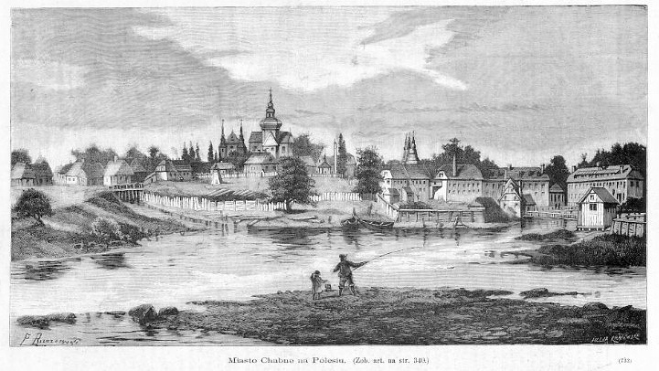
Originally called Khabnoye or Khabne (Russian: Хабное, Ukrainian: Хабне), it was renamed Kaganovichi Pervye or Kahanovychi Pershi (Russian: Кагановичи Первые, Ukrainian: Кагановичі Перші) in 1934, and Poliske in 1957.
Founded in the 15th century, it was the home of the Polish family Horwatt from 1850 to 1918. In the 19th century, this small city was known for its weavers and its textile industry. In 1890, 80% of the population was Jewish. In the later half of the 19th century, and in the beginning of the 20th century, there was known a klezmer band of the Makonowiecki family. Khabne lost all its major architecture during the Soviet Union – the castle of Radziwiłł, Orthodox churches, and the Catholic Church. In 1938, Khabne received official city status. After the Chernobyl disaster, Khabne's population started to fall off. In 1999, the remaining population was evacuated. In 2005, there were about 1,000 people still living there, mostly senior citizens.[citation needed][2]
From February to April 2022, Poliske was occupied by Russia as a result of the 2022 invasion.
Abandonment
Following the Chernobyl Nuclear Power Plant accident, a Zone of Alienation (Ukrainian: Зона відчуження Чорнобильської АЕС, zona vidchuzhennya Chornobyl's'koyi AES), also known as the Chernobyl Exclusion Zone, the 30 Kilometre Zone, or simply The Zone (Ukrainian: Чорнобильська зона, Chornobyl's'ka zona) was designated by the USSR military after the 1986 disaster.[3] Initially, 30 km radius area was evacuated and placed under military control, however, over time the borders of the Zone of Alienation have increased to cover a larger area of contamination.[4] The zone is now approximately 2,600 km2 (1,000 sq miles), where radioactive fallout contamination is highest.[5] Public access and inhabitation is restricted due to radiological hazards and allow for ecological monitoring by environmental scientists.[6] Ten "self settlers" have remained in the nuclear ghost town.
Geography
Located in the north-western corner of Kyiv Oblast, at the borders with Zhytomyr Oblast, Poliske is part of the natural region of Polesia, and is 27 km from the Belarusian border. Crossed by the regional highway P02 Ovruch-Kyiv (135 km south), the town lies between Vilcha (17 km north) and Krasiatychi (27 km south). It is 41 km far from Narodychi, 53 from Ovruch and Ivankiv, 58 from Pripyat and 65 from Chernobyl.[7]
Notable people
- Iser Kuperman, a seven-time world champion of draughts, was born in Khabne on 21 April 1922.
- Lazar Kaganovich, one of leaders of the Soviet Union, was born in the suburb of Kabany (Ukrainian: Кабани, Кабанів, Russian: Кабаны), (near Khabne) in 1893.
- Avraham-Yehoshua Makonovetsky, klezmer violinist, was born here in 1872 and was the leader of the town klezmer band from the 1890s into the Soviet era.
In popular culture
- In the game S.T.A.L.K.E.R.: Shadow of Chernobyl, there is a cut location called Dead City which appears to draw inspiration from Poliske.
See also
References
- Herbaut, Guillaume. "Poliske: The Forgotten City of Chernobyl". Retrieved 6 February 2015.
- Marples, David Roger (1986). Chernobyl and Nuclear Power in the USSR. CUIS Press. ISBN 978-0920862506. Retrieved 6 February 2015.
- Petryna, Adriana (2002). Life Exposed: Biological Citizens after Chernobyl. New Jersey: Princeton University Press. ISBN 978-0-691-09019-1.
- Marples, David R. (1988). The Social Impact of the Chernobyl Disaster. New York: St. Martin's Press. ISBN 0-312-02432-0.
- Mould, R. F. (2000). Chernobyl Record: The Definitive History of the Chernobyl Catastrophe. Bristol, UK: Institute of Physics Publishing. ISBN 0-7503-0670-X.
- Bondarkov, Mikhail D.; Oskolkov, Boris Y.; Gaschak, Sergey P.; Kireev, Sergey I.; Maksimenko, Andrey M.; Proskura, Nikolai I.; Jannik, G. Timothy (2011). "Environmental Radiation Monitoring in the Chernobyl Exclusion Zone - History and Results 25 Years After". Health Physics. Georgia: US: Savannah River National Laboratory. 101 (4): 442–85. doi:10.1097/HP.0b013e318229df28. PMID 21878769. S2CID 34630968.
- 50426438 Poliske on OpenStreetMap
External links
![]() Media related to Poliske at Wikimedia Commons
Media related to Poliske at Wikimedia Commons
На других языках
[de] Poliske
Poliske (ukrainisch Поліське; russisch Полесское .mw-parser-output .Latn{font-family:"Akzidenz Grotesk","Arial","Avant Garde Gothic","Calibri","Futura","Geneva","Gill Sans","Helvetica","Lucida Grande","Lucida Sans Unicode","Lucida Grande","Stone Sans","Tahoma","Trebuchet","Univers","Verdana"}Polesskoje) – ehemals Хабне Chabne, war eine Siedlung städtischen Typs im Nordwesten der Oblast Kiew an der Grenze zur Oblast Schytomyr mit ehemals 12.000 Einwohnern (1981: 10.600). Der Ort liegt am Fluss Usch, einem Zufluss des Prypjat.- [en] Poliske
[ru] Полесское (Киевская область)
Полесское (укр. Поліське) — бывший посёлок городского типа в Киевской области Украины, на реке Уж, до 1993 года центр Полесского района Киевской области. Находится в 15 км от железнодорожной станции Вильча.Другой контент может иметь иную лицензию. Перед использованием материалов сайта WikiSort.org внимательно изучите правила лицензирования конкретных элементов наполнения сайта.
WikiSort.org - проект по пересортировке и дополнению контента Википедии