world.wikisort.org - Ukraine
Lypovets (Ukrainian: Липовець) is a town in Vinnytsia Raion of Vinnytsia Oblast, Ukraine. Until the Administrative reform of 2020 it served as the administrative center of Lypovets Raion now disestablished. Population: 7,958 (2022 est.)[1]
Lypovets
Липовець | |
|---|---|
 Lypovets skyline | |
 Coat of arms | |
 Lypovets Map of Ukraine with Lypovets highlighted  Lypovets Lypovets (Ukraine) | |
| Coordinates: 49°13′15″N 29°03′25″E | |
| Country | |
| Oblast | |
| Raion | Vinnytsia Raion |
| Administrative Classification | KOATUU: 0522210100 |
| Area | |
| • Total | 10.33 km2 (3.99 sq mi) |
| Elevation | 242 m (794 ft) |
| Population (2022) | |
| • Total | 7,958 |
| • Density | 770/km2 (2,000/sq mi) |
| Demonym | Lypovets' |
| Time zone | UTC+2 (EET) |
| • Summer (DST) | UTC+3 (EEST) |
| Postal code | 22500-22505 |
| Area code | +380-4358 |
History
It was the administrative center of Lypovets uyezd in Kiev Governorate of the Russian Empire.
During World War II, Lypovets was occupied by Nazi German troops, from 1941, to 1944. As a result of this occupation, Lypovets was the site of a battle between the Soviet Union and the Slovak State. The battle ended with a Slovak victory, with a cumulative casualty count of nearly 700.
In January 1989 the population was 9764 people[2]
In January 2013 the population was 8727 people.[3]
Gallery
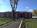 Lypovets district executive committee
 Sports ground
 Employment centre in Lypovets
 Palace of culture


Notable people
- Pyotr Stolyarsky (1871 – 1944), Soviet violinist and pedagogue
References
- Чисельність наявного населення України на 1 січня 2022 [Number of Present Population of Ukraine, as of January 1, 2022] (PDF) (in Ukrainian and English). Kyiv: State Statistics Service of Ukraine.
- Всесоюзная перепись населения 1989 г. Численность городского населения союзных республик, их территориальных единиц, городских поселений и городских районов по полу
- "Чисельність наявного населення України на 1 січня 2013 року. Державна служба статистики України. Київ, 2013. стор.43" (PDF). Archived from the original (PDF) on 12 October 2013. Retrieved 3 October 2019.
External links
- Website «Наш Липовець»
- The murder of the Jews of Lypovets during World War II, at Yad Vashem website.
Wikimedia Commons has media related to Lypovets.
Administrative center: Vinnytsia | ||
| Raions | ||
| Hromadas |
| |
| Cities | ||
| Urban-type settlements | ||
| Authority control: National libraries |
|---|
На других языках
[de] Lypowez
Lypowez (ukrainisch Липовець; russisch Липовец .mw-parser-output .Latn{font-family:"Akzidenz Grotesk","Arial","Avant Garde Gothic","Calibri","Futura","Geneva","Gill Sans","Helvetica","Lucida Grande","Lucida Sans Unicode","Lucida Grande","Stone Sans","Tahoma","Trebuchet","Univers","Verdana"}Lipowez, polnisch Łypowiec) ist eine Stadt in der Ukraine mit etwa 9.000 Einwohnern. Sie ist das administrative Zentrum des Rajons Lypowez und liegt im nordöstlichen Teil der Oblast Winnyzja am Fluss Sob.- [en] Lypovets
[ru] Липовец (город)
Ли́повец (укр. Липовець) — город в Винницкой области Украины. Входит в Винницкий район. До 2020 года был административным центром упразднённого Липовецкого района.Текст в блоке "Читать" взят с сайта "Википедия" и доступен по лицензии Creative Commons Attribution-ShareAlike; в отдельных случаях могут действовать дополнительные условия.
Другой контент может иметь иную лицензию. Перед использованием материалов сайта WikiSort.org внимательно изучите правила лицензирования конкретных элементов наполнения сайта.
Другой контент может иметь иную лицензию. Перед использованием материалов сайта WikiSort.org внимательно изучите правила лицензирования конкретных элементов наполнения сайта.
2019-2026
WikiSort.org - проект по пересортировке и дополнению контента Википедии
WikiSort.org - проект по пересортировке и дополнению контента Википедии