world.wikisort.org - Turkey
Bayındır is a district of İzmir Province of Turkey and the central town of the district which is situated in the valley of the Küçük Menderes.[3]
Bayındır | |
|---|---|
 | |
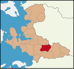 Bayındır District within the Province of İzmir | |
 Bayındır | |
| Coordinates: 38°13′09″N 27°38′53″E | |
| Country | Turkey |
| Province | İzmir |
| Government | |
| • Mayor | Mehmet Kertiş (AKP) |
| Area | |
| • District | 540.22 km2 (208.58 sq mi) |
| Population (2012)[2] | |
| • Urban | 21,785 |
| • District | 40,988 |
| • District density | 76/km2 (200/sq mi) |
History
Its name in classical antiquity was Caystrus (Κάϋστρος), near Smyrna. Its present name derives from Turkish people who in the 11th c. AD settled there; they were members of the Bayındır clan, one of the 24 original Oghuz clans. In 1997, the town population was 18,100. It is connected with İzmir by a branch of the Aydın railway, and has a trade in olives, olive oil, cotton, figs, raisins and tobacco.[3]
Transport
The district is crossed by the Torbalı-Tire railway, with a branch to Ödemiş. It is served by regional trains from/to İzmir (Basmane-Ödemiş and Basmane-Tire), and counts the stations of Arıkbaşı, Karpuzlu, Elifli, Furunlu, Bayındır (in the capital town), Yakaköy and Çatal.[4]
References
- "Area of regions (including lakes), km²". Regional Statistics Database. Turkish Statistical Institute. 2002. Retrieved 2013-03-05.
- "Population of province/district centers and towns/villages by districts - 2012". Address Based Population Registration System (ABPRS) Database. Turkish Statistical Institute. Retrieved 2013-02-27.
- One or more of the preceding sentences incorporates text from a publication now in the public domain: Chisholm, Hugh, ed. (1911). "Baindir". Encyclopædia Britannica. Vol. 3 (11th ed.). Cambridge University Press. p. 223. The cited information may be out of date.
- 1841223 Bayındır on OpenStreetMap
External links
![]() Media related to Bayındır at Wikimedia Commons
Media related to Bayındır at Wikimedia Commons
Bayındır in Izmir Province of Turkey | |||||||||||||||||||||||||||
|---|---|---|---|---|---|---|---|---|---|---|---|---|---|---|---|---|---|---|---|---|---|---|---|---|---|---|---|
| Districts |  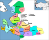 | ||||||||||||||||||||||||||
|
Metropolitan municipalities are bolded. | |||||||||||||||||||||||||||
Authority control | |
|---|---|
| General |
|
| National libraries | |
This geographical article about a location in İzmir Province, Turkey is a stub. You can help Wikipedia by expanding it. |
Другой контент может иметь иную лицензию. Перед использованием материалов сайта WikiSort.org внимательно изучите правила лицензирования конкретных элементов наполнения сайта.
WikiSort.org - проект по пересортировке и дополнению контента Википедии